Velmej
Velmej is a village in Debarca municipality.
Location
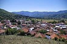
Velmej is located at Dolna Debarca region, 13 km. east from the high road Ohrid-Kicevo high road.
On the western slopes of mountain Ilinska Bigla, from the north and the east side, the village is surrounded with the mountain massifs of Ilinska Bigla, (to the east is Kilaec peakat 1068 m, to the north is Čuki at 1303 m) and in the west and south sides is the Velmej field.
The village's altitude is 860 m. The area of the village Velmej takes 39.3 km2 or 10% of the territory of Debarca.
The closest airport to Velmej is OHD-Ohrid, located 18.7 km southwest of Velmej. Other nearby airports include SKP-Skopje 95.0 km to the northeast and TIA-Tirana Rinas 99.7 km to the west.
Places near Velmej, Macedonia: 3.2 km to Grko Pole, 3.5 km to Sošani, 4.1 km to Lešani, 4.1 km to Gorno Sredoreče, 4.7 km to Dolno Sredoreče, 6.3 km to Kuratica, 5.4 km to Ozdoleni, 6.3 km to Slatino, 5.8 km to Brežani, 6.0 km to Belčišta, 6.2 km to Zlesti, 7.6 km to Izdeglavje, 8.5 km to Sirula, 10.1 km to Arbinovo, 10.7 km to Plakje.
History
During the Second World War, in 1943, Karaorman Mountain, about 30 km. from Ohrid, covered with dense vegetation and abounding in game, particularly the region around Debarca on its eastern slopes, became the centre of partisan activity. The first free territory in Western Macedonia was established there. The region of Debarca was especially favorable for the development of partisan warfare, in which the local population engaged in large numbers.
The first National Liberation Committees were set up in Debarca on liberated territory in the spring of 1943. Their task was to organize life throughout the free territory. The Debarca District National Liberation Committee devoted special attention to education.
The first schools with classes on the Macedonian language were opened in October and November 1943 in Velmej, Vrbjani, Belciste, Botun and other Ohrid villages.
Economy
55.3% of the surface area of Velmej is forest and mountains, 22.4% is farmland, and 22.3% is in the moorland.
Culture
In the Ohrid region there are several Neolithic settlements: Dolno Trnovo in Ohrid and Zlastrana in the village of Gorno Sredorece (Debarca), as well as the Kutlina site in the village of Velmej (Debarca), which dates back to the Eneolithic period.
At the centre of Velmej is a high bell tower of St Nikolas church. There is another church, St. George which looks down on northwards part of the village.
Also, an impressive fountain called ”Istok” (East) which disposes large amount of water running through 18 sources is situated at the western part of the village. That is the place where the traditional wedding ceremony called ”Bringing water by the bride” happens. Nowadays, there is a water system through the village, built in 1982, but “Istok” still brings together the inhabitants of Velmej.
Near the fountain is a tablet of fallen fighters of People's Liberation War and Ilinden rebellion.
Sports
FC Ilinden Velmej - win the Cup of the region 2006
Notable people
- Zoran Stavreski - minister of finance of the Government Republic of Macedonia
- Ljube Trpeski - ex-governor of National Bank of the Republic of Macedonia
- Ilija Iloski - ex-Director of Customs Administration of the Republic of Macedonia, ex-member of Assembly of the Republic of Macedonia - Chief Operating Officer, Director of KMB - Komercijalna Banka Skopje
- Miroslav Ginoski - Director of EMO Metrology Products
Coordinates: 41°18′N 20°54′E / 41.300°N 20.900°E