Vermillion Township, Vermillion County, Indiana
| Vermillion Township | |
|---|---|
| Township | |
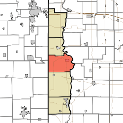 Location in Vermillion County | |
| Coordinates: 39°52′16″N 87°27′19″W / 39.87111°N 87.45528°WCoordinates: 39°52′16″N 87°27′19″W / 39.87111°N 87.45528°W | |
| Country | United States |
| State | Indiana |
| County | Vermillion |
| Government | |
| • Type | Indiana township |
| Area | |
| • Total | 50.98 sq mi (132.0 km2) |
| • Land | 50.51 sq mi (130.8 km2) |
| • Water | 0.47 sq mi (1.2 km2) 0.92% |
| Elevation | 614 ft (187 m) |
| Population (2010) | |
| • Total | 924 |
| • Density | 18.3/sq mi (7.1/km2) |
| ZIP codes | 47847, 47854 47928, 47966 |
| GNIS feature ID | 453954 |
Vermillion Township is one of five townships in Vermillion County, Indiana, United States. As of the 2010 census, its population was 924 and it contained 401 housing units.[1]
History
Vermillion Township took its name from Vermillion County, which was named after the Vermilion River.[2]
Geography
According to the 2010 census, the township has a total area of 50.98 square miles (132.0 km2), of which 50.51 square miles (130.8 km2) (or 99.08%) is land and 0.47 square miles (1.2 km2) (or 0.92%) is water.[1]
Cities
Unincorporated towns
Cemeteries
The township contains twelve cemeteries: Carmack, Johnson, Johnson, Juliet, Lebanon, Memorial Chapel, Miller, Old Hopewell, Thomas, Walnut Hill, Wimsett and Zener.
Landmarks
- Newport Chemical Depot
- The Newport Covered Bridge was listed on the National Register of Historic Places in 1994.[3]
School districts
- North Vermillion Community School Corporation
Political districts
- Indiana's 8th congressional district
- State House District 42
- State Senate District 38
References
- 1 2 "Population, Housing Units, Area, and Density: 2010 - County -- County Subdivision and Place -- 2010 Census Summary File 1". United States Census. Retrieved 2013-05-10.
- ↑ History of Parke and Vermillion Counties, Indiana. B.F. Bowen & Cos. 1913. p. 423.
- ↑ National Park Service (2010-07-09). "National Register Information System". National Register of Historic Places. National Park Service.
External links
 |
Love Township, Vermilion County, Illinois | Eugene Township | Liberty Township, Parke County | |
| Prairie Township, Edgar County, Illinois | |
Reserve Township, Parke County | ||
| ||||
| | ||||
| Helt Township |
Municipalities and communities of Vermillion County, Indiana, United States | ||
|---|---|---|
| City | ||
| Towns | ||
| Townships | ||
| CDPs | ||
| Other unincorporated communities | ||
| Ghost towns | ||
| Footnotes | ‡This populated place also has portions in an adjacent county or counties | |
This article is issued from Wikipedia - version of the 10/18/2016. The text is available under the Creative Commons Attribution/Share Alike but additional terms may apply for the media files.