Vermont Route 214
| ||||
|---|---|---|---|---|
|
Map of Washington County in central Vermont with VT 214 highlighted in red | ||||
| Route information | ||||
| Maintained by VTrans | ||||
| Length: | 2.061 mi[1] (3.317 km) | |||
| Existed: | 1955[2] – present | |||
| Major junctions | ||||
| South end: |
| |||
| North end: |
| |||
| Location | ||||
| Counties: | Washington | |||
| Highway system | ||||
| ||||

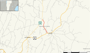
Vermont Route 214 (VT 214) is a 2.061-mile-long (3.317 km) state highway located in Washington County, Vermont, United States. The route begins at a junction with US 2 in the town of Plainfield. The route serves a short connector to VT 14 in the town of East Montpelier. The route, which was first designated in 1955, passes nearby Goddard College.
Route description
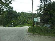
VT 214 begins at a junction with U.S. Route 2 (Main Street) in the town of Plainfield near the shores of the Winooski River. The route runs northwest along the eastern edge of the campus of Goddard College, passing a junction with Pitkin Road, which serves as the main road through the campus. Shortly after Sugarwood Road, VT 214 runs northwest into the town of Marshfield for a short distance. Now entering the town of East Montpelier, the route passes several fields and residences, which soon winds north through a stretch of dense woods. After making a slow bend to the northwest, VT 214 into the hamlet of North Montpelier and into a junction with VT 14. The junction marks the northern terminus of VT 214 and the right-of-way ends at this junction.[3]
History
VT 214 was first designated on its current alignment in 1955 because of a move of the Vermont State Legislature.[2]
Major intersections
The entire route is in Washington County. [1]
| Location[1] | mi[1] | km | Destinations | Notes | |
|---|---|---|---|---|---|
| Plainfield | 0.000 | 0.000 | |||
| East Montpelier | 2.061 | 3.317 | |||
| 1.000 mi = 1.609 km; 1.000 km = 0.621 mi | |||||
References
- 1 2 3 4 Traffic Research Unit (May 2013). "2012 (Route Log) AADTs for State Highways" (PDF). Policy, Planning and Intermodal Development Division, Vermont Agency of Transportation. Retrieved April 25, 2015.
- 1 2 State Highway History (in Chronological Order) (PDF) (Report). Vermont Agency of Transportation. October 5, 2007. p. 7. Retrieved January 4, 2014.
- ↑ Microsoft; Nokia (January 4, 2014). "overview map of Route 214" (Map). Bing Maps. Microsoft. Retrieved January 4, 2014.
External links
| Wikimedia Commons has media related to Vermont Route 214. |