Vesan
| Vesan | |
|---|---|
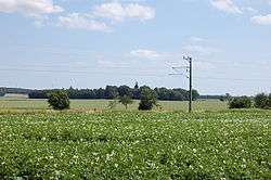 The church of Gammalstorp seen on the former island in the former lake. | |
| Location | Sölvesborg |
| Coordinates | 56°06′18″N 14°38′26″E / 56.104981°N 14.6406555°ECoordinates: 56°06′18″N 14°38′26″E / 56.104981°N 14.6406555°E |
| Primary outflows | 8 miljon kubicmeters/year[1] |
| Basin countries | Sweden |
Lake Vesan: the lake system Vesan in Sölvesborg was from the beginning not a lake, but a strait until the early 1920s. In the area between Ryssberget and Listerlandet, water from Hanöbukten flowed in and in effect cut off Listerlandet from the rest of the mainland. The sound was open to sail through until the 18th century, but increased growth of reeds made the opening too narrow.[2]
Nowadays it is farmland in the former lake, and the church of Gammalstorp lies on the small hill that formerly was an island.
References
- ↑ "Planprogram för SÖLVE VERKSAMHETSOMRÅDE". Planprogram för SÖLVE VERKSAMHETSOMRÅDE. county of Sölvesborg. Retrieved 12 July 2011.
- ↑ Geological Institution at the University of Lund
This article is issued from Wikipedia - version of the 5/25/2016. The text is available under the Creative Commons Attribution/Share Alike but additional terms may apply for the media files.