Veterans Memorial Bridge (Missouri)
This article is about the bridge over the Missouri River. For the bridge over the Mississippi River, see Stan Musial Veterans Memorial Bridge. For another bridge over the Mississippi that once used this name, see Martin Luther King Bridge (St. Louis).
| Veterans Memorial Bridge | |
|---|---|
 | |
| Coordinates | 38°44′13″N 90°31′20″W / 38.737°N 90.5223°WCoordinates: 38°44′13″N 90°31′20″W / 38.737°N 90.5223°W |
| Carries |
10 lanes of |
| Crosses | Missouri River |
| Locale | St. Louis County and St. Charles County in Missouri |
| Maintained by | Missouri Department of Transportation |
| Characteristics | |
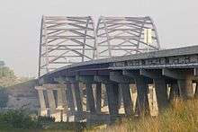
| Design | Twin tied-arch bridges |
| Total length | 988.8 m (3,244 ft) |
| Width | 2 x 27.4 m (2 x 90 ft), 54.8 m (180 ft) total |
| Longest span | 187.8 m (616 ft) |
| History | |
| Opened | December 13, 2003 |
| Statistics | |
| Daily traffic | 46,706 (2008)[1] |
The Veterans Memorial Bridge are two twin tied arch structures carrying Route 364 across the Missouri River between St. Louis County and St. Charles County, Missouri. Each bridge supports five lanes of traffic, the northern (downstream) bridge westbound, and the southern (upstream) bridge eastbound.
On the north (downstream) side of the bridge runs a bike path that connects Creve Coeur Memorial Park to the Katy Trail.
See also
References
- ↑ "2008 District 6 Traffic Volume and Commercial Vehicle Count Map" (PDF). MoDOT. Retrieved 9 July 2010.
| Crossings of the Missouri River | ||||
|---|---|---|---|---|
| ||||
This article is issued from Wikipedia - version of the 6/24/2014. The text is available under the Creative Commons Attribution/Share Alike but additional terms may apply for the media files.