Vichy — Charmeil Airport
| Vichy - Charmeil Airport Aéroport de Vichy - Charmeil | |||||||||||
|---|---|---|---|---|---|---|---|---|---|---|---|
| IATA: VHY – ICAO: LFLV | |||||||||||
| Summary | |||||||||||
| Airport type | Public | ||||||||||
| Operator | Mairie de Vichy | ||||||||||
| Serves | Vichy, France | ||||||||||
| Location | Charmeil | ||||||||||
| Elevation AMSL | 817 ft / 249 m | ||||||||||
| Coordinates | 46°10′18″N 003°24′15″E / 46.17167°N 3.40417°ECoordinates: 46°10′18″N 003°24′15″E / 46.17167°N 3.40417°E | ||||||||||
| Map | |||||||||||
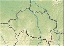 LFLV Location of airport in Allier department Location of Allier department in France 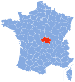 | |||||||||||
| Runways | |||||||||||
| |||||||||||
Vichy - Charmeil Airport (French: Aéroport de Vichy - Charmeil) (IATA: VHY, ICAO: LFLV) is an airport located in Charmeil, 5 km (3 NM) north-northwest of Vichy,[1] both communes in the Allier department of the Auvergne region in central France.
Facilities
The airport resides at an elevation of 817 feet (249 m) above mean sea level. It has one runway designated 01/19 with an asphalt surface measuring 2,200 by 45 metres (7,218 ft × 148 ft).[1]
References
- 1 2 3 LFLV – VICHY CHARMEIL. AIP from French Service d'information aéronautique, effective 8 December 2016.
External links
- Airport information for LFLV at World Aero Data. Data current as of October 2006.
This article is issued from Wikipedia - version of the 12/4/2016. The text is available under the Creative Commons Attribution/Share Alike but additional terms may apply for the media files.