Victoria Avenue (Riverside, California)
For other uses, see Victoria Avenue (disambiguation).
|
Victoria Avenue | |
|
Victoria Avenue, which bisects Riverside, hosts many species of trees and plants. | |
| Location | Victoria Ave., from Arlington Ave. to Boundary Ln., Riverside, California |
|---|---|
| Coordinates | 33°55′33″N 117°23′57″W / 33.92583°N 117.39917°WCoordinates: 33°55′33″N 117°23′57″W / 33.92583°N 117.39917°W |
| Area | 88.7 acres (35.9 ha) |
| Built | 1892[1] |
| Architect | Hosp, Franz Philip[1] |
| NRHP Reference # | 00001267[2] |
| RIVL # | 8 |
| Added to NRHP | October 26, 2000 |
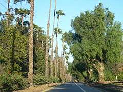
Victoria Avenue is a divided scenic road in Riverside, California, that cuts through an area referred to as the greenbelt. Originally developed in 1892 to connect the Arlington Heights area to downtown Riverside, the road became a popular tourist attraction because of the many trees and exotic plants used to landscape the route.[3] Beyond the landscaping, the road was surrounded by navel orange groves, the crop that spurred Riverside's growth. Many of the groves still exist today.
External links
- City of Riverside Parks, Recreation & Community Services—descriptive information and video
- Victoria Avenue Forever—a citizens preservation organization
- Victoria Avenue Historic Restoration Project
References
- 1 2 Riverside Cultural Heritage Board (January 2002). "Landmarks of the City of Riverside" (PDF). City of Riverside. Retrieved 2013-02-28.
- ↑ "National Register Information System". National Register of Historic Places. National Park Service. 2000-10-26.
- ↑ Lech, Steve. Riverside in Vintage Postcards. Arcadia Publishing, Charleston, SC. ISBN 0-7385-2978-8.
| Topics | |
|---|---|
| Lists by states |
|
| Lists by insular areas | |
| Lists by associated states | |
| Other areas | |
| |
This article is issued from Wikipedia - version of the 11/29/2016. The text is available under the Creative Commons Attribution/Share Alike but additional terms may apply for the media files.