Vientiane
| Vientiane ວຽງຈັນ Viang chan | |
|---|---|
| Capital City | |
 Vientiane | |
| Coordinates: 17°58′N 102°36′E / 17.967°N 102.600°ECoordinates: 17°58′N 102°36′E / 17.967°N 102.600°E | |
| Country |
|
| Admin. division | Vientiane Prefecture |
| Settled | 9th century[1] |
| Area | |
| • Total | 3,920 km2 (1,510 sq mi) |
| Elevation | 174 m (570 ft) |
| Population (2013 est) | |
| • Total | 783,000 |
| • Density | 200/km2 (520/sq mi) |
Vientiane (/vjɛnˈtjɑːn/; French pronunciation: [vjɛ̃ˈtjan]; Lao: ວຽງຈັນ, Viang chan, IPA: [wíəŋ tɕàn]) is the capital and largest city of Laos, on the banks of the Mekong River near the border with Thailand. Vientiane became the capital in 1563 due to fears of a Burmese invasion, but ironically, the city was razed and looted to the ground in 1827 by the Siamese (Thai).[2] Vientiane was the administrative capital during French rule and, due to economic growth in recent times, is now the economic centre of Laos.
The estimated population of the city is 760,000 (2015). The city hosted the 25th Southeast Asian Games in December 2009 celebrating the 50 years of Southeast Asian Games.
Etymology
The name of the city is derived from Pali, the liturgical language of Theravada Buddhism. Although the original meaning of the name of the city is "city of sandalwood", as shown by ancient Lao inscription which wrote according to etymology, unlike modern Lao which is written phonetically, in modern Lao, the meaning of the name Vientiane is ambiguous.
Many, if not most, Lao people claim that the city's name means "city of the moon", while many also claim correctly that the city's name means "city of sandalwood" because the words for "moon" (ຈັນ or ຈັນທຣ໌ from chandra चन्द्र in Sanskrit) and "sandalwood" (ຈັນ or ຈັນທນ໌ from chandana चन्दन in Sanskrit) are written and pronounced identically as "chan" in modern Lao. Most academic and historic Lao sources claim that the city's name does in fact mean "city of sandalwood", reinforced by the city's Thai (เวียงจันทน์) and Khmer (វៀងចន្ទន៍) names both retain the etymological spelling, which indicates "city of sandalwood".
The romanised spelling "Vientiane" is of French origin, and reflects the difficulty the French had in pronouncing the hard "ch" sound in the Lao language. A common English-based spelling is "Viangchan", or occasionally "Wiangchan".
History
The great Laotian epic, the Phra Lak Phra Lam, claims that Prince Thattaradtha founded the city when he left the legendary Lao kingdom of Muong Inthapatha Maha Nakhone because he was denied the throne in favor of his younger brother. Thattaradtha founded a city called Maha Thani Si Phan Phao on the western banks of the Mekong River; this city was said to have later become today's Udon Thani, Thailand. One day, a seven-headed Naga told Thattaradtha to start a new city on the east bank of the river opposite Maha Thani Si Phan Phao. The prince called this city Chanthabuly Si Sattanakhanahud; which was said to be the predecessor of modern Vientiane.
Contrary to the Phra Lak Phra Lam, most historians believe Vientiane was an early Khmer settlement centered around a Hindu temple, which the Pha That Luang would later replace. In the 11th and 12th centuries, the time when the Lao and Thai people are believed to have entered Southeast Asia from Southern China, the few remaining Khmers in the area were either killed, removed, or assimilated into the Lao civilization, which would soon overtake the area.
In 1354, when Fa Ngum founded the kingdom of Lan Xang.[3]:223 Viangchan became an important administrative city, even though it was not made the capital. King Setthathirath officially established it as the capital of Lan Xang in 1563, to avoid Burmese invasion.[4] When Lan Xang fell apart in 1707, it became an independent Kingdom of Vientiane. In 1779, it was conquered by the Siamese general Phraya Chakri and made a vassal of Siam.
When King Anouvong raised an unsuccessful rebellion, it was obliterated by Siamese armies in 1827. The city was burned to the ground and was looted of nearly all Laotian artifacts, including Buddha statues and people. Viangchan was in great disrepair, depopulated and disappearing into the forest, when the French arrived. It eventually passed to French rule in 1893. It became the capital of the French protectorate of Laos in 1899. The French rebuilt the city and rebuilt or repaired Buddhist temples such as Pha That Luang, Haw Phra Kaew, and left many colonial buildings behind.
During World War II, Viangchan fell with little resistance and was occupied by Japanese forces, under the command of Sako Masanori.[5] On 9 March 1945 French paratroopers arrived, and reoccupied the city on 24 April 1945.[6]
As the Laotian Civil War broke out between the Royal Lao Government and the Pathet Lao, Vientiane became unstable. In August 1960, Kong Le seized the capital and insisted that Souvanna Phouma become prime minister. In mid-December, Phoumi Nosavan then seized the capital, overthrew the Phouma Government, and installed Boun Oum as prime minister. In mid-1975, Pathet Lao troops moved towards the city and Americans began evacuating the capital. On 23 August 1975, a contingent of 50 Pathet Lao women symbolically liberated the city.[6] On 2 December 1975, the communist party of the Pathet Lao took over Vientiane, defeated the Kingdom of Laos, and renamed the country the Lao People's Democratic Republic, which ended the Laotian Civil War. The next day, an Insurgency in Laos began in the jungle, with the Pathet Lao fighting factions of Hmong and royalists.
Vientiane was the host of the incident-free 2009 Southeast Asian Games. Eighteen competitions were dropped from the previous games held in Thailand, due to Laos' landlocked borders and the lack of adequate facilities in Vientiane.
Administration
Vientiane is located in and is the capital of the Vientiane Prefecture (Nakhonluang Vientiane). There is also the Vientiane Province—the prefecture was split off from the province in 1989.
Vientiane city comprises the following districts:
- Chanthabouly
- Hadxaifong
- Sikhottabong
- Sisattanak
- Saythany
- Naxaithong
- Pak Ngeum
- Sangthong
- Xaysetha
Geography and climate
| Vientiane | ||||||||||||||||||||||||||||||||||||||||||||||||||||||||||||
|---|---|---|---|---|---|---|---|---|---|---|---|---|---|---|---|---|---|---|---|---|---|---|---|---|---|---|---|---|---|---|---|---|---|---|---|---|---|---|---|---|---|---|---|---|---|---|---|---|---|---|---|---|---|---|---|---|---|---|---|---|
| Climate chart (explanation) | ||||||||||||||||||||||||||||||||||||||||||||||||||||||||||||
| ||||||||||||||||||||||||||||||||||||||||||||||||||||||||||||
| ||||||||||||||||||||||||||||||||||||||||||||||||||||||||||||
Geography
Vientiane is on a bend of the Mekong River, at which point it forms the border with Thailand.
Climate
Vientiane features a tropical wet and dry climate (Köppen Aw) with a distinct monsoon season and a dry season. Vientiane’s dry season spans from November through March. April marks the onset of the monsoon which in Vientiane lasts about seven months. Vientiane tends to be hot and humid throughout the course of the year, though temperatures in the city tend to be somewhat cooler during the dry season than the wet season.
| Climate data for Vientiane | |||||||||||||
|---|---|---|---|---|---|---|---|---|---|---|---|---|---|
| Month | Jan | Feb | Mar | Apr | May | Jun | Jul | Aug | Sep | Oct | Nov | Dec | Year |
| Record high °C (°F) | 35.6 (96.1) |
37.8 (100) |
40.0 (104) |
41.1 (106) |
38.9 (102) |
37.8 (100) |
36.1 (97) |
37.2 (99) |
38.9 (102) |
38.9 (102) |
34.4 (93.9) |
33.4 (92.1) |
41.1 (106) |
| Average high °C (°F) | 28.4 (83.1) |
30.3 (86.5) |
33.0 (91.4) |
34.3 (93.7) |
33.0 (91.4) |
31.9 (89.4) |
31.3 (88.3) |
30.8 (87.4) |
30.9 (87.6) |
30.8 (87.4) |
29.8 (85.6) |
28.1 (82.6) |
31.1 (88) |
| Average low °C (°F) | 16.4 (61.5) |
18.5 (65.3) |
21.5 (70.7) |
23.8 (74.8) |
24.6 (76.3) |
24.9 (76.8) |
24.7 (76.5) |
24.6 (76.3) |
24.1 (75.4) |
22.9 (73.2) |
19.3 (66.7) |
16.7 (62.1) |
21.8 (71.2) |
| Record low °C (°F) | 0.0 (32) |
7.6 (45.7) |
12.1 (53.8) |
17.1 (62.8) |
20.0 (68) |
21.1 (70) |
21.2 (70.2) |
21.1 (70) |
21.2 (70.2) |
12.9 (55.2) |
8.9 (48) |
5.0 (41) |
0.0 (32) |
| Average rainfall mm (inches) | 7.5 (0.295) |
13.0 (0.512) |
33.7 (1.327) |
84.9 (3.343) |
245.8 (9.677) |
279.8 (11.016) |
272.3 (10.72) |
334.6 (13.173) |
297.3 (11.705) |
78.0 (3.071) |
11.1 (0.437) |
2.5 (0.098) |
1,660.5 (65.374) |
| Average rainy days | 1 | 2 | 4 | 8 | 15 | 18 | 20 | 21 | 17 | 9 | 2 | 1 | 118 |
| Average relative humidity (%) | 70 | 68 | 66 | 69 | 78 | 82 | 82 | 84 | 83 | 78 | 72 | 70 | 75 |
| Mean monthly sunshine hours | 254.4 | 214.3 | 216.8 | 226.3 | 207.1 | 152.9 | 148.6 | 137.1 | 137.7 | 247.7 | 234.3 | 257.5 | 2,434.7 |
| Source #1: World Meteorological Organization,[8] Deutscher Wetterdienst (extremes 1907–1990)[9] | |||||||||||||
| Source #2: NOAA (sun and humidity)[10] | |||||||||||||
Tourism
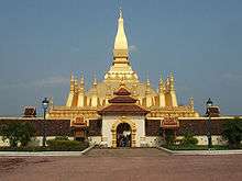
Although still a small city, the capital experiences a major influx of tourists. The city contains many temples and Buddhist monuments with Pha That Luang, a Buddhist stupa, one of the most famous in Laos. It is the most important national cultural monument and very popular amongst foreign tourists. The original was built in 1566 by King Setthathirath, and was restored in 1953. The golden stupa is 45 metres tall and is believed to contain a relic of the Lord Buddha.[11]
Another site that is also popular amongst tourists is Wat Si Muang. The temple was built on the ruins of a Khmer Hindu shrine, the remains of which can be seen behind the ordination hall.[12] It was built in 1563 and is believed to be guarded by the spirit of a local girl called “Si". Legend says that Nang Si, who was pregnant at the time, leapt to her death as a sacrifice, just as the pillar was being lowered into the hole. In front of the temple stands a statue of King Sisavang Vong.[12]
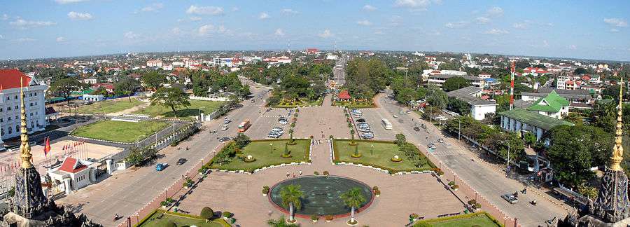
The memorial monument, Patuxai, began construction in 1957 and completed in 1968, is perhaps the most prominent landmark in the city.[11] While the Arc de Triomphe in Paris inspired the architecture, the design incorporates typical Lao motifs including “Kinnari”, a mythical bird woman. Energetic visitors can climb to the top of the monument, which reveals an panoramic view of the city.
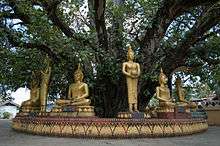
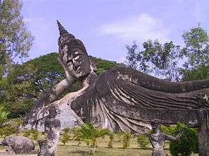
Buddha Park was built in 1958 by Luang Pu Bunleua Sulilat and contains a collection of Buddhist and Hindu sculptures, scattered amongst gardens and trees. The park was built about 28 kilometres south of Vientiane at the edge of the Mekong River.[13]
Vientiane is home to one of the three bowling alleys in Laos (the other two are in Luang Prabang and Pakse). There are many upper-class hotels in Vientiane.
Other sites include:
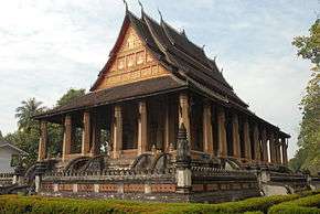
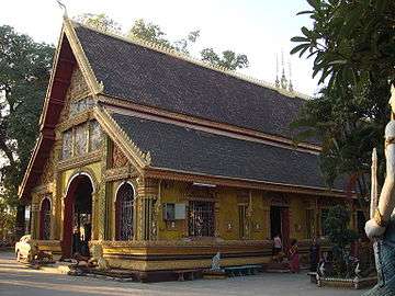
- Haw Phra Kaew, former temple, now museum and small shops
- Lao National Museum
- Talat Sao Morning market
- That Dam, large stupa
- Wat Ong Teu Mahawihan, Buddhist monastery
- Wat Si Saket, Buddhist wat
- Wat Sok Pa Luang, Buddhist temple
- Settha Palace Hotel, Established 1932
- The Sanjiang Market[14]
Colleges and universities
The National University of Laos, one of three universities in the country, is in Vientiane.[15]
Broadcasting
- Lao National Radio has a large mediumwave transmitter with a 277-metre guyed mast at 18° 20' 33"N, 102° 27' 01"E
- China Radio International (CRI) FM 93.0[16]
- Radio Australia: FM 96.0
Economy
Vientiane is the driving force behind economic change in Laos. In recent years, the city has experienced rapid economic growth from foreign investment.[17] In 2011, the stock exchange opened with two listed company stocks, with the cooperation of South Korea.[18]
Transportation
Within Laos
There are regular bus services connecting Vientiane Bus Station with the rest of the country. In Vientiane, regular bus services around the city are provided by Vientiane Capital State Bus Enterprise.[19]
From Thailand

The First Thai-Lao Friendship Bridge, built in the 1990s, crosses the river 18 kilometres downstream of the city of Nong Khai in Thailand, and is the major crossing between the two countries. The official name of the bridge was changed in 2007 by the addition of "First", after the Second Friendship Bridge linking Mukdahan in Thailand with Savannakhet in Laos was opened early in 2007.
A metre gauge railway link over the bridge was formally inaugurated on 5 March 2009, ending at Thanaleng Railway Station, in Dongphosy village (Vientiane Prefecture), 20 km east of Vientiane.[21][22] As of November 2010, Lao officials plan to convert the station into a rail cargo terminal for freight trains, allowing cargo to be transported from Bangkok into Laos at a lower cost than would be possible with road transport.[23]
To Thailand
Daily non-stop bus services run between Vientiane and Nong Khai, Udon Thani, and Khon Kaen.
From China
In October 2010, plans were announced for a 530 km high-speed railway linking Vientiane to Xishuangbanna, in Yunnan Province in China.[24] which was later modified to a high speed train from Boten to Vientiane with total distance of 421.243 km to be served by 21 stations including 5 major stations passing through 165 bridges (total length of 92.6 km) and 69 tunnels (total length of 186.9 km)[25][26] Construction on this line—as part of the longer Kunming to Singapore Railway began on 25 April 2011.[27]
By air
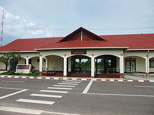
Vientiane is served by Wattay International Airport with international connections to other Asian countries. Lao Airlines has regular flights to several domestic destinations in the country (including several flights daily to Luang Prabang, plus a few flights weekly to other local destinations).[28] In Thailand, Udon Thani International Airport, one of Wattay's main connections, is less than 90 km distant.
Healthcare
The "Centre Medical de l'Ambassade de France" is available to the foreign community in Laos. The Mahosot Hospital is an important local hospital in treating and researching diseases and is connected with the University of Oxford. In 2011 the Alliance Clinic opened near the airport, with a connection to Thai hospitals. The Setthathirat International Clinic has foreign doctors. A free, 24/7 ambulance service is provided by Vientiane Rescue, a volunteer-run rescue service established in 2010.[29]
Twin towns – Sister cities
Vientiane is twinned with:
-
 Bangkok, Thailand
 -
 Chittagong, Bangladesh
 -
 Phnom Penh, Cambodia
 -
 Ho Chi Minh City, Vietnam
 -
 Cirebon, Indonesia
See also
References
- ↑ Lonely Planet. "History of Vientiane Province - Lonely Planet Travel Information". Retrieved 18 July 2015.
- ↑ "Vientiane". Farlex Encyclopedia. Retrieved 25 Nov 2010.
- ↑ Coedès, George (1968). Walter F. Vella, ed. The Indianized States of Southeast Asia. trans.Susan Brown Cowing. University of Hawaii Press. ISBN 978-0-8248-0368-1.
- ↑ "Vientiane marks 450 years anniversary". Retrieved 18 July 2015.
- ↑ "Far East and Australasia". Archived from the original on November 21, 2010. Retrieved 25 Nov 2010.
- 1 2 Far East and Australasia 2003 - Google Books
- ↑ "World Weather Information Service — Vientiane". World Meteorological Organisation. Retrieved 2010-10-31.
- ↑ "World Weather Information Service - Vientiane (1951-2000)". World Meteorological Organization. Retrieved May 14, 2010.
- ↑ "Klimatafel von Vientiane (Viangchan) / Laos" (PDF). Baseline climate means (1961-1990) from stations all over the world (in German). Deutscher Wetterdienst. Retrieved January 23, 2016.
- ↑ "Vientiane Climate Normals 1961−1990". National Oceanic and Atmospheric Administration. Retrieved November 29, 2013.
- 1 2 Lao National Tourism Administration - Tourist Sites in Vientiane Capital Archived July 23, 2011, at the Wayback Machine.
- 1 2 "Wat Si Muang". Retrieved 18 July 2015.
- ↑ "Buddha Park - Vientiane - Laos - Asia for Visitors". Retrieved 18 July 2015.
- ↑ "China Gives Southeast Asia's Poorest First Time Access to Consumer Goods - China Briefing News". China Briefing News.
- ↑ "National University of Laos (NUOL)". National University of Laos (NUOL). NUOL. Retrieved 2014-12-08.
- ↑ "China Radio International".
- ↑ Work begins on major new Vientiane shopping centre | Lao Voices Archived May 3, 2011, at the Wayback Machine.
- ↑ "Laos stocks soar on debut – yes, both of them". Financial Times.
- ↑ "Timetables". Vientiane Capital State Bus Enterprise. VCSBE. Retrieved 2014-12-08.
- ↑ Matthias Gasnier (2012-08-13). "Laos 2012 Update: Chinese models keep spreading". bestsellingcarsblog.com. Retrieved 2013-11-10.
- ↑ "Inaugural train begins Laos royal visit". Railway Gazette International. 2009-03-05.
- ↑ Andrew Spooner (2009-02-27). "First train to Laos". The Guardian. Retrieved 2011-03-13.
- ↑ Rapeepat Mantanarat (2010-11-09). "Laos rethinks rail project". TTR Weekly. Archived from the original on July 27, 2011. Retrieved 2011-03-13.
- ↑ "New China-Laos link". Railways Africa. Archived from the original on January 31, 2014. Retrieved 2010-12-07.
- ↑ "Boten Vientiane Railway Link". Laos-Travel-Guide. Archived from the original on July 13, 2011. Retrieved 2011-01-18.
- ↑ "中国铁路考察团对中老铁路进行全线考察 | China Railway Erju Group Corporation (中铁二局集团公司)" (PDF). Archived from the original (PDF) on July 8, 2011. Retrieved 2010-12-25.
- ↑ "Kunming-Singapore High-Speed Railway begins construction". People's Daily. 25 Apr 2011. Archived from the original on April 29, 2011. Retrieved 26 Apr 2011.
- ↑ "Route Map". Lao Airlines. Lao Airlines. Retrieved 2014-12-08.
- ↑ "About". Vientiane Rescue. Retrieved 11 October 2016.
Further reading
- Askew, Marc, William Stewart Logan, and Colin Long. Vientiane: Transformations of a Lao Landscape. London: Routledge, 2007. ISBN 978-0-415-33141-8
- Sharifi et al., Can master planning control and regulate urban growth in Vientiane, Laos?. Landscape and Urban Planning, 2014. DOI: 10.1016/j.landurbplan.2014.07.014
- Flores, Penelope V. Good-Bye, Vientiane: Untold Stories of Filipinos in Laos. San Francisco, CA: Philippine American Writers and Artists, Inc, 2005. ISBN 978-0-9763316-1-2
- Renaut, Thomas, and Arnaud Dubus. Eternal Vientiane. City heritage. Hong Kong: Published by Fortune Image Ltd. for Les Editions d'Indochine, 1995.
- Schrama, Ilse, and Birgit Schrama. Buddhist Temple Life in Laos: Wat Sok Pa Luang". Bangkok: Orchid Press, 2006. ISBN 978-974-524-073-5
- Women's International Group (Viangchan, Laos). Vientiane Guide. [Vientiane]: Women's International Group, 1993.
External links
-
 Vientiane travel guide from Wikivoyage
 -
 Media related to Vientiane at Wikimedia Commons
 - Pictures of Vientiane on Flickr
- Map of Vientiane
- Laos-Travel-Guide.com Vientiane Travel Guide
- Vientiane: Gourmet Grasshoppers - video report by Global Post
- Vientiane on Google Maps
- MSN Map
| Attapu | |
|---|---|
| Bokeo | |
| Bolikhamsai | |
| Champassack | |
| Houaphanh | |
| Khammouane | |
| Louang Namtha | |
| Luang Prabang | |
| Oudomxay | |
| Phongsaly | |
| Salavan | |
| Savannakhet | |
| Sekong | |
| Vientiane |
|
| Vientiane (Viengchan) |
|
| Xaignabouli | |
| Xiangkhouang | |