Villebaudon
| Villebaudon | |
|---|---|
|
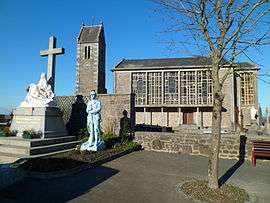
The church of Sainte-Anne | |
 Villebaudon | |
|
Location within Normandy region  Villebaudon | |
| Coordinates: 48°57′40″N 1°09′55″W / 48.9611°N 1.1653°WCoordinates: 48°57′40″N 1°09′55″W / 48.9611°N 1.1653°W | |
| Country | France |
| Region | Normandy |
| Department | Manche |
| Arrondissement | Saint-Lô |
| Canton | Percy |
| Intercommunality | Communauté de communes du canton de Percy |
| Government | |
| • Mayor (2008–2014) | Liliane Jamard |
| Area1 | 5.69 km2 (2.20 sq mi) |
| Population (2006)2 | 282 |
| • Density | 50/km2 (130/sq mi) |
| Time zone | CET (UTC+1) |
| • Summer (DST) | CEST (UTC+2) |
| INSEE/Postal code | 50637 / 50410 |
| Elevation | 99–183 m (325–600 ft) |
|
1 French Land Register data, which excludes lakes, ponds, glaciers > 1 km² (0.386 sq mi or 247 acres) and river estuaries. 2 Population without double counting: residents of multiple communes (e.g., students and military personnel) only counted once. | |
Villebaudon is a commune in the Manche department in Normandy in north-western France.
Transportation
Villebaudon is located on the crossroads of the D999 and the D13.
History
The village was liberated during operation 'COBRA' the breakout by the American army on 29 July 1944 after some very heavy fighting lasting 13 hours, 11 German tanks were destroyed and 180 German defenders killed.
See also
| Wikimedia Commons has media related to Villebaudon. |
This article is issued from Wikipedia - version of the 3/15/2016. The text is available under the Creative Commons Attribution/Share Alike but additional terms may apply for the media files.