Villiers-sous-Grez
For places named Villiers, in whole or in part, see Villiers (disambiguation).
| Villiers-sous-Grez | |
|---|---|
 Villiers-sous-Grez | |
|
Location within Île-de-France region  Villiers-sous-Grez | |
| Coordinates: 48°19′13″N 2°38′56″E / 48.3203°N 2.6489°ECoordinates: 48°19′13″N 2°38′56″E / 48.3203°N 2.6489°E | |
| Country | France |
| Region | Île-de-France |
| Department | Seine-et-Marne |
| Arrondissement | Fontainebleau |
| Canton | La Chapelle-la-Reine |
| Intercommunality | |
| Government | |
| • Mayor (2008–2014) | Brigitte Delahaye |
| Area1 | 12.25 km2 (4.73 sq mi) |
| Population (2006)2 | 784 |
| • Density | 64/km2 (170/sq mi) |
| Time zone | CET (UTC+1) |
| • Summer (DST) | CEST (UTC+2) |
| INSEE/Postal code | 77520 / 77760 |
| Elevation | 65–133 m (213–436 ft) |
|
1 French Land Register data, which excludes lakes, ponds, glaciers > 1 km² (0.386 sq mi or 247 acres) and river estuaries. 2 Population without double counting: residents of multiple communes (e.g., students and military personnel) only counted once. | |
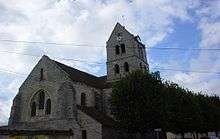
The church Eglise Saint Etienne, built in 13th century
Villiers-sous-Grez is a commune in the Seine-et-Marne department in the Île-de-France region in north-central France.
Demographics
Inhabitants of Villiers-sous-Grez are called Villarons.
See also
References
External links
| Wikimedia Commons has media related to Villiers-sous-Grez. |
- 1999 Land Use, from IAURIF (Institute for Urban Planning and Development of the Paris-Île-de-France région) (English)
- French Ministry of Culture list for Villiers-sous-Grez (French)
- Map of Villiers-sous-Grez on Michelin (English)
This article is issued from Wikipedia - version of the 11/19/2014. The text is available under the Creative Commons Attribution/Share Alike but additional terms may apply for the media files.