Virvasselva
| Virvasselva / Virvassåga | |
| Lule Sami: Viresjåhkå | |
| River | |
 View of the river | |
| Country | Norway |
|---|---|
| Region | Nordland |
| Municipality | Rana |
| Source | Virvatnet |
| - elevation | 645 m (2,116 ft) |
| - coordinates | 66°18′36″N 15°24′12″E / 66.31000°N 15.40333°E |
| Mouth | Ranelva |
| - elevation | 319 m (1,047 ft) |
| - coordinates | 66°26′48″N 15°07′54″E / 66.44667°N 15.13167°ECoordinates: 66°26′48″N 15°07′54″E / 66.44667°N 15.13167°E |
| Length | 21 km (13 mi) |
Virvasselva or Virvassåga (Lule Sami: Viresjåhkå) is a river in the municipality of Rana in Nordland county, Norway. The river flows out of the eastern part of the lake Virvatnet. The stream Boneselva meets Virvasselva about 1 kilometre (0.62 mi) east of the lake Virvatnet. This is a large, continuous, very rich and untouched wetland area with tarns, rivers, marshes, and very tight vegetation. Virvasselva has a good population of Arctic char.
After about 5 kilometres (3.1 mi), the river Virvasselva reaches a pumping station where most of the water is diverted through a tunnel to flow west to supply the Rana power station. The much smaller river then continues north and meets the main river Ranelva at Elvmøtheia in the Dunderlandsdal valley.[1]
Media gallery
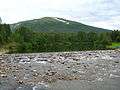 The lowest part of Virvasselva
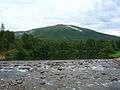 The lowest part of Virvasselva
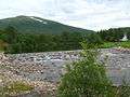 The lowest part of Virvasselva
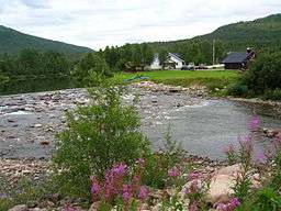
 Virvasselvas meeting with Ranelva (on the right)
References
- ↑ Store norske leksikon. "Rana kraftstasjon" (in Norwegian). Retrieved 2011-12-19.