Visaginas Municipality
| Visaginas Municipality Visagino savivaldybė | |||
|---|---|---|---|
| Municipality | |||
| |||
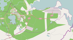 Map of Visaginas Municipality | |||
| Coordinates: LT 55°35′12″N 26°30′31″E / 55.58667°N 26.50861°ECoordinates: LT 55°35′12″N 26°30′31″E / 55.58667°N 26.50861°E | |||
| Country |
| ||
| Ethnographic region | Aukštaitija | ||
| County | Utena County | ||
| Administrative centre | Visaginas | ||
| Settlements | 18[1] | ||
| Area[2] | |||
| • Total | 58 km2 (22 sq mi) | ||
| Area rank | 58th | ||
| Population (2011)[2] | |||
| • Total | 27,113 | ||
| • Rank | 43rd | ||
| • Density | 470/km2 (1,200/sq mi) | ||
| • Density rank | 7th | ||
| Telephone code | 386 | ||
| Major settlements | Visaginas (pop. 26,804)[2] | ||
| Website |
www | ||


The Visaginas Municipality (Lithuanian: Visagino savivaldybė) is one of the 60 municipalities of Lithuania, situated in the north-east of the country. It consists of the city of Visaginas (administrative centre of the municipality), 16 villages (kaimai) and one farmstead (viensėdis).
History
For the history prior to 1994, see Visaginas § History.
The municipality was formally established on 19 July 1994 as the Visaginas City Municipality (Visagino miesto savivaldybė) and came into actual existence following the local election on 25 March 1995. Initially the municipality was composed only of the city of Visaginas, but on 1 January 2003 its area was expanded by absorbing a part of the Ignalina District Municipality, and the Visaginas City Municipality was renamed to what it is known as now.[3]
References
- ↑ (Lithuanian) Address register of Lithuania
- 1 2 3 Demographic Yearbook stat.gov.lt
- ↑ (Lithuanian) Law on the alteration of the borders of territories of the Visaginas City and Ignalina District municipalities
External links
| Municipalities |  | |
|---|---|---|
| Cities | ||
| Towns | ||
| Villages | ||
This article is issued from Wikipedia - version of the 5/14/2016. The text is available under the Creative Commons Attribution/Share Alike but additional terms may apply for the media files.