Vuoksi River
| Vuoksi (Vuoksa) | |
|---|---|
 | |
| Country | Finland, Russia |
| Basin | |
| Main source |
Lake Saimaa 74 m (243 ft) 61°13′00″N 28°47′22″E / 61.21667°N 28.78944°E |
| River mouth | Lake Ladoga |
| Basin size | Greater than 52,400 km2 (20,200 sq mi) |
| Physical characteristics | |
| Length | 162 km (101 mi) |
| Discharge |
|
The Vuoksi (Russian: Вуокса; Finnish: Vuoksi; Swedish: Vuoksen) is a river running through the northernmost part of the Karelian Isthmus from Lake Saimaa in southeastern Finland to Lake Ladoga in northwestern Russia. The river enters Lake Ladoga in three branches, an older main northern branch at Priozersk (Käkisalmi), a smaller branch a few kilometres to the north of it, and a new southern branch entering 50 kilometres (31 mi) further southeast as Burnaya River (Finnish: Taipaleenjoki), which has become the main stream in terms of water discharge. Since 1857, the old northern distributaries drain only the lower reaches of the Vuoksi basin and are not fed by Lake Saimaa. The northern and southern branches actually belong to two separate river systems, which at times get isolated from each other in dry seasons.
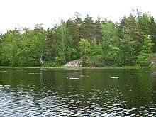
The descent between Lake Saimaa and Lake Ladoga is 69 metres (226 ft). The entire run of the river is 162 kilometres (101 mi) via the Priozersk branch, or 150 kilometres (93 mi) via the Taipale branch. For most of its length, the river broadens out to a series of lakes bound together by shorter riverlike connections. One of these lakes, Uusijärvi close to Priozersk, was renamed Ozero Vuoksa ("Lake Vuoksa") by the Soviets.
The Vuoksi connects Lake Ladoga with central Finland, and was once an important route for trade and communication. A western branch, which disappeared due to ongoing land uplift, was an alternative route for the Karelians to reach the Gulf of Finland when the Neva River was blocked by enemies. Now the Saimaa Canal bypasses the Vuoksi and enters the Gulf of Finland in the Bay of Vyborg near the medieval city of Vyborg.
During both the Winter and Continuation Wars the river Vuoksi was a major Finnish defensive line against the Soviet advance. The Mannerheim Line and VKT-line were located along the northern shore of its southern armlet.
From the Industrial Revolution, power generated from Vuoksi's rapids made the Vuoksi region Finland's industrial center in the late 19th century. Since the Winter War (1940), the Karelian Isthmus has belonged to Russia and only 13 kilometres (8 mi) of the river's length remains in Finland. The major power stations at Tainionkoski and Imatra are on the Finnish side in the city of Imatra.
The river's surroundings, including the Korela Fortress (formerly: Käkisalmi), is a popular resort for Saint Petersburg's residents.
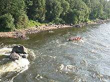
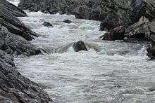
The river is famous for its rapids, for instance Imatrankoski in Imatra and rapid in the village of Losevo (Kiviniemi). The rapid junction of the Vuoksi and Suvanto/Lake Sukhodolskoye at Losevo is a popular area for kayak, canoe and catamaran competitions.
A project is currently being discussed in Russia to destroy the rapids at Losevo and turn the River Burnaya, Lake Sukhodolskoye and lower portions of Vuoksi into a navigable canal, which would connect Lake Ladoga to the Gulf of Finland and allow oil tankers to bypass River Neva and the city of Saint Petersburg.
Geological history

Around 5,000 BP the waters of the Saimaa Lake penetrated Salpausselkä, forming the river emptying into Lake Ladoga in its northwestern corner and raising the level of the latter by 1 to 2 metres (3 to 7 ft). Lake Ladoga transgressed, flooding lowland lakes and the Vuoksi, and connected with the Baltic Sea at Heinjoki, to the east of present-day Vyborg. Ladoga's level gradually sank and the River Neva, originating around 3100–2400 BP, drained its waters into the Gulf of Finland; but the Vuoksi still had a significant direct outflow connection to the Bay of Vyborg, possibly as late as in the 16th or 17th century AD. The connection disappeared due to ongoing land uplift.[1][2][3]
In 1818, a canal was dug to drain spring flood waters from Lake Suvanto (now Lake Sukhodolskoye, a 40-kilometre (25 mi) long narrow lake in the eastern part of the Karelian Isthmus) into Lake Ladoga; the canal unexpectedly eroded and turned into Taipaleenjoki (now Burnaya River). Taipaleenjoki started draining Suvanto and decreased its level by 7 metres (23 ft). Originally Lake Suvanto flowed into the Vuoksi river through a waterway at Kiviniemi (now Losevo), but as a result of the change, the waterway dried out. In 1857 a channel was dug there, but the stream reversed direction, creating rapids and rendering navigation at Kiviniemi impossible. Since 1857 Suvanto and Taipaleenjoki have constituted the southern branch of the Vuoksi river, which has decreased the level of the original northern branch emptying into Ladoga near Kexholm (now Priozersk) by 4 metres (13 ft) and has become the main stream.
References
- ↑ Davydova, Natalia N. et al. (1996). Late- and postglacial history of lakes of the Karelian Isthmus. Hydrobiologia 322.1-3, 199-204.
- ↑ Saarnisto, Matti & Tuulikki Grönlund (1996). Shoreline displacement of Lake Ladoga - new data from Kilpolansaari. Hydrobiologia 322.1-3, 205-215.
- ↑ Saarnisto, Matti (1970). The Late Weichselian and Flandrian history of the Saimaa Lake complex. Societas Scientiarium Fennicae. Commentationes Physico-Mathematicae 37.
External links
| Wikimedia Commons has media related to Vuoksa. |
- The creation of the Vuoksi River preceded a significant cultural shift, September 15, 2014, Phys.org