Wa State
| Wa State ဝပြည်နယ် Mēng Vax 佤邦 |
||||
|---|---|---|---|---|
|
||||
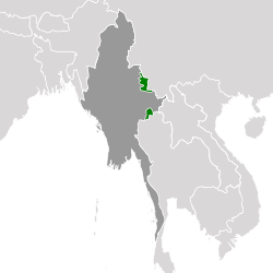 Wa State, as claimed by the UWSA (green),
within Myanmar (dark grey). |
||||
| Capital and largest city | Pangkham 22°10′N 99°11′E / 22.167°N 99.183°E | |||
| Spoken languages | ||||
| Government | One-party military junta | |||
| • | President | Bao Youxiang[1] | ||
| • | Vice President | Xiao Minliang[2] | ||
| Independence from Myanmar | ||||
| • | Declared | 17 April 1989 | ||
| • | Officially administrated as the Wa Self-Administered Division | 20 August 2010 | ||
| • | Recognition | Unrecognized | ||
| Area | ||||
| • | 17,000 km2 6,564 sq mi |
|||
| • | Water (%) | negligible | ||
| Population | ||||
| • | estimate | 558,000 | ||
| • | Density | 32.8/km2 12.7/sq mi |
||
| Currency | Renminbi | |||
| Time zone | MMT (UTC+06:30) | |||
| Drives on the | right | |||
| Calling code | +95 73 | |||
Wa State (Wa: Mēng Vax or Meung Va; Chinese: 佤邦; pinyin: Wǎ Bāng; Burmese: ဝပြည်နယ်) is an unrecognised state in Myanmar (Burma) and is currently subsumed under the official Wa Special Region 2 of northern Shan State.[3][4] The administrative capital is Pangkham (Chinese: 邦康; pinyin: Bāngkāng, formerly known as Panghsang, 邦桑). The name Wa derives from the Wa ethnic group, who speaks a language in the Austroasiatic family of languages.
Many of the Wa are animists, and a small proportion of the population follows a derivative of either Buddhism or Christianity. The Wa were once known as the "Wild Wa" by the British due to their practice of headhunting.[5]
Politics and society
Wa State is divided into northern and southern regions which are separated from one another, with the 13,000 km2 (5,000 sq mi) southern region bordering Thailand and consisting of 200,000 people. The total area of the region controlled by the Wa State is 17,000 km2 (6,600 sq mi). Political leaders of the Wa State are mostly ethnic Wa people. The government of the Wa State emulates many political features of the government of China, having a Central Committee and a central party known as the United Wa State Party. Whilst the Wa State is de facto highly autonomous from the control of the central Myanmar government,[6][7] their relationship is based on peaceful coexistence and the Wa State recognises the sovereignty of the central government over all of Myanmar.[8]
The working language of the Wa State government is Chinese.[9][10][11] Southwest Mandarin and Wa widely spoken by the population, with the language of education being Standard Mandarin Chinese. Television broadcasts within the Wa State are broadcast in Standard Chinese and Wa. Commodities within the Wa State are brought over from China, and the Renminbi is used for exchanges. China Mobile has cellular coverage over some parts of the Wa State.[8]
History
For a long time, headman tribes were dispersed around the Wa mountainous area, with no unified governance. During the Qing Dynasty, the region became separated from the tribal military control of the Dai people. British rule in Burma did not administer the Wa States[12] and the border with China was left undefined.[13]
From the late 1940s, during the Chinese Civil War, remnants of the Chinese National Revolutionary Army retreated to territory within Burma as the communists took over mainland China. Within the mountain region Kuomintang forces of the Eighth Army 237 division and 26th Army 93 division held their position for two decades in preparation for a counterattack towards mainland China. Under pressure from the United Nations, the counterattack was cancelled and the army was recalled to northern Thailand and later back to Taiwan; however, some troops decided to remain within Burma. East of the Salween river, indigenous tribal guerilla groups exercised control with the support of the Burmese Communist Party.
During the 1960s, the Burmese Communist Party lost its base of operations within central Burma, and with the assistance of the Chinese communists, expanded within the border regions. Many intellectual youths from China joined the Burmese Communist Party, and these forces also absorbed many local guerillas.[14] The Burmese communists gained control over Pangkham, which became their base of operations.
At the end of the 1980s, the ethnic minorities of northeast Burma became politically separated from the Burmese Communist Party. On 17 April 1989, Bao Youxiang's armed forces announced their separation from the Burmese Communist Party, and formed the United Myanmar Ethnics Party, which later became the United Wa State Party. On 18 May, the Wa State and Myanmar military junta formed a ceasefire agreement.
Tensions between the central government and Wa state were heightened in 2009.[15] During this time, peace initiative proposals by the Wa State were rejected by the Myanmar government.[16] The government warned on 27 April 2010 that the WHP program could push Myanmar and the Wa State into further conflict.[17]
Communism
After the Communist Party of Burma lost control of its bases in central Burma in the late 1960s, it re-established itself in the northeast including Wa State, with the support of China. The Wa, like other ethnic groups were fighting for autonomy from Burma, and supported the CPB. They eventually rebelled along with the Kokang against the Burmese communist leadership, which was forced into exile across the Chinese border, at the time of the 8888 Uprising in mainland Burma. Following the subsequent collapse of the Burma Socialist Programme Party (BSPP) rule under Ne Win in Burma, the WNO made ceasefire and peace agreements with the new military regime, the State Law and Order Restoration Council (SLORC).
Subdivisions
Wa State comprises seven districts (townships) of what the Myanmar government officially deems as the Shan State. Internally, Wa State administers 15 districts within its territory.
|
|
Geography and economy

The region is mainly mountainous, with deep valleys. The lowest points are approximately 600 metres above sea level, with the highest mountains over 3000 metres. Initially the Wa State was heavily reliant on opium production.[18] With Chinese assistance, there has been a move towards growing rubber and tea plantations.[19] The Wa State cultivates 220,000 acres of rubber.[20] Due to the resettlement of residents from mountainous areas to fertile valleys,[21] there is also cultivation of wet rice, corn and vegetables. Dozens died during the resettlement due to disease and road accidents.[20] Wa State is economically dependent on China, which supports it financially and provides military and civilian advisors and weapons.[22][23] It shares 82 miles (133 km) of frontier with China.[24]
Illicit drug trade
Using its 30,000 personnel, the United Wa State Army (UWSA) is the largest narcotics trafficking organization in Southeast Asia. It was once allied with the Communist Party of Burma (4,000 soldiers). The UWSA cultivates vast areas of land for the opium poppy, which is later refined to heroin. Methamphetamine trafficking is also important to the economy of the Wa State.[20] The money from the opium is used for weapons. Although the Burmese government has begun taking measures to decrease the production of such drugs, it is an arduous task due to corruption at high levels in the government and a lack of infrastructure to carry out operations.[25] In 2005, Wa State was declared by the UWSP as a drug-free zone and the cultivation of opium was prohibited.[21][26]
A BBC presentation aired on 19 th November 2016 showed the burning of metamphetamine as well as a thriving trade in illegal animal parts.
See also
References
Citations
- ↑ Quote: "Officially, Bao Youxiang is still the President of the Wa State Government and Commander-in-Chief of the United Wa State Army," said a Thai security officer, a ten-year veteran on the Thai-Burma border
- ↑ "A United Wa State Army (UWSA) delegation led by Vice President Xiao Minliang, Bao Youliang and Zhao Guo-ang left Panghsang for Lashio today". democracy for burma. Retrieved 29 November 2014.
- ↑ 2004-12-29, 佤帮双雄, Phoenix TV
- ↑ Soldiers of Fortune, Time Magazine. Quote: In return for keeping the peace, the UWSA was given full autonomy over what the regime termed "Special Region No. 2," which Bao christened "Wa state."
- ↑ "Headhunting days are over for Myanmar's "Wild Wa"", Reuters, Sep 10, 2007.
- ↑ 2009年9月, 不透明さ増すミャンマー情勢:2010年総選挙に向けて, IDE-JETRO
- ↑ 2011年11月15日, 地図にない街、ワ州潜入ルポが凄い『独裁者の教養』, エキサイトレビュー
- 1 2 2011-10-13, 缅甸佤邦竟然是一个山寨版的中国, 军情观察
- ↑ Interactive Myanmar Map, The Stimson Center
- ↑ Wa, Infomekong
- ↑ General Background of the Wa. Quote: The official languages (designated by the current UWSP administration) are Mandarin and Wa.
- ↑ Sir J. George Scott, Burma : a handbook of practical information. London 1906, p.
- ↑ N Ganesan & Kyaw Yin Hlaing eds. Myanmar: State, Society and Ethnicity Institute of Southeast Asian Studies, February 1, 2007, p. 269
- ↑ 佤邦歷史, Wa State government
- ↑ Myanmar: Krieg mit Rebellen im Wa-Staat droht
- ↑ Naypyitaw turns down Wa’s latest proposal
- ↑ Shan rebel leader warns Burma Army
- ↑ Die Wa in Gefahr (German)
- ↑ "Xinhua General News Service: China develops more substitute crops for opium poppy in bordering countries"
- 1 2 3 Myanmar's strongest ethnic armed group says drug label 'not fair'
- 1 2 BURMA NACHRICHTEN 4/2005, 25. Februar (German). Quote: "Angaben der UN-Organisation zur Drogenbekämpfung UNODC und weiterer Beobachter zufolge droht durch die Ausführung des Plans zur Eliminierung des Opiumanbaus bis 2005 eine ernste humanitäre Krise der vom Opiumanbau abhängigen Bauern."
- ↑ China remains the UWSA's sole patron and arms supplier
- ↑ World Politics Watch: On Myanmar-China border, tensions escalate between SPDC, narco-militias – Michael Black
- ↑ UWSA Talks Business, Drugs Cooperation with China
- ↑ 缅甸第二特区佤邦,一切好象是中国的一个延伸, 2011-10-15.
- ↑ Myanmar Strategic Programme Framework
Sources
- Hideyuki Takano, The Shore Beyond Good and Evil: A Report from Inside Burma's Opium Kingdom (2002, Kotan, ISBN 0-9701716-1-7)
- Andrew Marshall, The Trouser People: a Story of Burma in the Shadow of the Empire. London: Penguin; Washington: Counterpoint, 2002. ISBN 1-58243-120-5.
- The Wa State, Burma The National Strategy Forum Review
- "Wa leader: UWSA able to defend itself". panglong.org. Shan Herald. 19 April 2012. Retrieved 5 May 2012.
- Forbes, Andrew ; Henley, David (2011). Traders of the Golden Triangle. Chiang Mai: Cognoscenti Books. ASIN: B006GMID5.
- Midnight in Burma. Ein Roman über die Tochter eines Generals im Wa-Staat, nicht gerade historisch mit vielen historischen Fehlern, aber sehr spannend geschrieben, Alex O'Brien. Asia Books ISBN 974-8303-58-6 (2001).
- Dr. Ba Nyan, Who are the Wa?
External links
- (Chinese) Wa state News Bureau(Sina blog)
- (Standard Mandarin) Television news broadcast from Wa State
- DEA Page
- Wa - Burma Issues
Coordinates: 22°10′N 99°00′E / 22.167°N 99.000°E