Wairere Falls
For Wairere Falls and power station in King Country see Mokau River.
| Wairere Falls | |
|---|---|
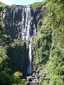 Wairere Falls from the viewing platform | |
| Location | Waikato, New Zealand |
| Type | Tiered |
| Total height | 153m |
| Watercourse | Wairere Stream |
Wairere Falls, the highest waterfall in New Zealand's North Island, plunges 153 metres (500 feet) in two steps over the Kaimai escarpment[1]
The waterfall is located between Te Aroha and Matamata. A walking track runs from the car park at the end of Goodwin Road, up the valley of the stream to a viewing platform, and thence to the top of the plateau and the crest of the falls. Once at the top one can continue onto the North South track that runs the length of the Kaimai Ranges.
References
- ↑ Jock Phillips. Waterfalls - Causes of waterfalls, Te Ara - the Encyclopedia of New Zealand, Ministry for Culture and Heritage. ISBN 978-0-478-18451-8. Updated 21 September 2007. Retrieved 22 May 2009.
External links
- Wairere Falls Track, Department of Conservation
- Flickr set of the hike to the falls
Coordinates: 37°44′02″S 175°52′48″E / 37.734°S 175.88°E
This article is issued from Wikipedia - version of the 11/18/2016. The text is available under the Creative Commons Attribution/Share Alike but additional terms may apply for the media files.