Wanaka
| Wanaka | |
|---|---|
| Town | |
 Wanaka Location of Wanaka within New Zealand | |
| Coordinates: 44°42′S 169°09′E / 44.700°S 169.150°ECoordinates: 44°42′S 169°09′E / 44.700°S 169.150°E | |
| Country | New Zealand |
| Region | Otago |
| Territorial authority | Queenstown Lakes District |
| Elevation | 290 m (950 ft) |
| Population (June 2016)[1] | |
| • Total | 7,850 |
| Time zone | NZST (UTC+12) |
| • Summer (DST) | NZDT (UTC+13) |
| Postcode | 9305 |
| Area code | 03 |
Wanaka /ˈwɒnəkə/ is a popular ski and summer resort town in the Otago region of the South Island of New Zealand. It is situated at the southern end of Lake Wanaka, at the start of the Clutha River. It is the gateway to Mount Aspiring National Park.
Wanaka is primarily a resort town but has both summer and winter seasons. Its economy is based on the many outdoor opportunities this offers. The town was originally settled during the gold rush of the 19th century. Along with the rest of the Queenstown-Lakes District, it is growing rapidly, with the population increasing by 50% between 2005 and 2015.
History
The first European in the area was Nathaniel Chalmers, who was guided inland by Chief Reko in 1853. Maori knowledge of the region is evidenced by an earlier sketch map from Chief Te Huruhuru at Waimate.[2]
European settlement began in the Upper Clutha River Valley in the 1850s, with the establishment of sheep stations by runholders. The first station was at Albert Town, the only place where settlers could ford the Clutha River. The present site of Wanaka was first surveyed in 1863,[2] and settlement increased in Pembroke (the old name for Wanaka) during the 1870s because of timber milling in the Matukituki Valley and the use of Lake Wanaka for transport. Tourism in the town began in 1867 with the opening of the first hotel, by Theodore Russell. Wanaka proved a very popular tourist destination because of its borderline continental climate and easy access to snow and water.[3]
The world's first sheepdog trials were reportedly held in Wanaka in 1867.[4]
Pembroke was renamed Wanaka in 1940.[2]
Geography

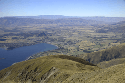
The town of Wanaka is situated at the southern end of Lake Wanaka. It is surrounded by mountains. To the southwest is the Crown Range and town of Queenstown (120 kilometres (75 mi)); to the north the Haast Pass cuts through the Southern Alps near Makarora. To the northeast are the towns of Omarama and Twizel. Very close to Lake Wanaka is Lake Hāwea, in a parallel glacial valley, which has a recently developed settlement of about 1,500 people. To the south of the town lies more of the Southern Alps. The Glendhu Bay motorpark is close to the town, leading into the Matukituki River valley. This gives access to the Mount Aspiring National Park.
The centre of the town lies on flat land beside Roy's Bay. Parts of the town have expanded into the hills surrounding the centre and around Roy's Bay in both directions. The lakeside area of the town is prone to occasional flooding in spring, when heavy rain and snowmelt can cause the lake to rise quickly. Such a flood occurred in November 1999.[5][6]
Climate
Despite its Oceanic climate, Wanaka is one of the few areas in New Zealand to enjoy a semi-continental climate, with four distinct seasons. The weather is fairly dry, with spring (September–December) being the wettest season. Annual rainfall is 682 mm which is half the national average. Wanaka experiences warm summers with temperatures reaching the high 20s, but with an average summer maximum of 24 °C. Winter can be extreme by New Zealand standards with temperature mostly in the single digits during the day time followed by cold and frosty nights and frequent snowfalls.
| Climate data for Wanaka | |||||||||||||
|---|---|---|---|---|---|---|---|---|---|---|---|---|---|
| Month | Jan | Feb | Mar | Apr | May | Jun | Jul | Aug | Sep | Oct | Nov | Dec | Year |
| Average high °C (°F) | 23.9 (75) |
23.4 (74.1) |
20.8 (69.4) |
17.3 (63.1) |
12.2 (54) |
8.4 (47.1) |
8.4 (47.1) |
11.0 (51.8) |
14.4 (57.9) |
16.8 (62.2) |
19.8 (67.6) |
21.9 (71.4) |
16.53 (61.73) |
| Average low °C (°F) | 10.8 (51.4) |
10.4 (50.7) |
8.4 (47.1) |
5.1 (41.2) |
1.6 (34.9) |
−0.9 (30.4) |
−1.2 (29.8) |
−0.2 (31.6) |
2.4 (36.3) |
5.0 (41) |
7.3 (45.1) |
9.6 (49.3) |
4.86 (40.73) |
| Average precipitation mm (inches) | 56.9 (2.24) |
50.2 (1.976) |
60.7 (2.39) |
56.4 (2.22) |
62.7 (2.469) |
54.5 (2.146) |
52.2 (2.055) |
52.8 (2.079) |
56.4 (2.22) |
63.1 (2.484) |
54.7 (2.154) |
51.9 (2.043) |
672.5 (26.476) |
| Mean monthly sunshine hours | 231.5 | 201.7 | 182.6 | 164.0 | 135.5 | 120.5 | 126.6 | 155.8 | 172.5 | 193.8 | 202.2 | 212.1 | 2,098.8 |
| Source: http://www.lakewanaka.co.nz/content/library/Weather_data.pdf | |||||||||||||
Wanaka wine sub-region
The area around Wanaka is a formal sub-region of the Central Otago wine region with several top wineries and vineyards. As with other parts of the wine region, the main grape variety in the area is pinot noir.
Attractions
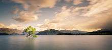
With its lake and mountain views, Wanaka has become a popular tourist resort, considered less commercialised than Queenstown.[7]
Wanaka boasts a growing number of restaurants, cafes and a diverse nightlife. Other attractions in the town include Puzzling World and the Paradiso Cinema. Puzzling World contains a maze, optical illusions and a leaning clocktower.[8] The Paradiso is a classic old cinema, with seating consisting of old couches and an in-theatre Morris Minor.[9] There are a number of wineries in the area. Just out of town next to the Wanaka Airport is the National Transport and Toy Museum.
In winter, Wanaka is an excellent place to see the Southern Lights.[10]
A number of mountains surrounding Wanaka can be climbed, including Roys Peak, Mount Iron, Mount Grand and the Pisa Range, all of which provide views of the surrounding area.
Festivals
- The biennial Warbirds over Wanaka airshow, has become a major attraction for national and international guests.
- Wanakafest
- NZ Freeski open
- The biennial New Zealand music Rippon Festival
- Challenge Wanaka Triathlon Festival
- Festival of Colour and Aspiring Conversations. Two festivals organised by the Southern Lakes Arts Festival Trust. The Festival of Colour is a biennial multi disciplinary arts festival featuring theatre, music, dance and visual arts. Aspiring Conversations is an ideas festival. Both are timed for April in alternate years.
- Rhythm and Alps
Summer
Wanaka is host to outdoor recreation and tourism activities with hiking, mountain biking, mountaineering, fishing, paragliding, kayaking, rafting, jetboating, and environmental activities. Wanaka has a sunny climate and serves as an access point to the highest New Zealand mountain outside of the Mount Cook region: Mount Aspiring/Tititea.
Mount Aspiring National Park is popular for mountaineering and hiking. Tourists enjoy day trips into the park and many tourists go hiking in the park for up to a week at a time. Parts of the Matukituki Valley on the road to the park are popular for rock climbing, and for day walks.
Lake Wanaka itself is popular for waterskiing, wakeboarding and sailing. This along with the local rivers provide many opportunities for fishing. There is a dedicated mountain biking area made by volunteers in a local pine forest.[12] Adjacent to the bike park is an 18 hole disc golf course. All the local ski resorts are open for mountain biking and hiking in the summer.
Winter

Wanaka has the broadest range of snow activity choices of any town in NZ. These include Treble Cone, Cardrona Alpine Resort, Snow Park and Snow Farm, some of New Zealand's premier commercial ski fields. Wanaka is the main accommodation provider for these resorts and so is very busy in high season (July–September).
Treble Cone has good lift-accessed terrain and for this reason has become popular amongst visitors, 'ConeHeads'.[13] It also catches some of the better snow in the area, with its location and orientation getting more snow from NW storms.
Cardrona is more attractive to families and beginners, though an attempt has been made at the park riding population in competition with SnowPark.[14] Snowpark is a dedicated 100% artificial terrain park for advanced riders. Snow Farm is New Zealand's only commercial cross-country ski field.
Cardrona also hosts one of the few Olympic sized halfpipes in the world and has been used for practice for Olympic competition.[15]
People
Wanaka is home to 7,850 people as of June 2016.[1] It is the country's 39th-largest urban area and the fourth-largest urban area in Otago behind Dunedin, Oamaru and Queenstown.
| Historical population | ||
|---|---|---|
| Year | Pop. | ±% p.a. |
| 1996 | 2,600 | — |
| 2001 | 3,450 | +5.82% |
| 2006 | 5,280 | +8.88% |
| 2013 | 6,820 | +3.72% |
| Source: [16] | ||
The 2013 census counted 6,471 permanent residents in the Wanaka urban area, 28.4 percent more than seven years earlier. The median age of residents was 41.1 years; around 16.7% of residents were aged 65 or over and 18.5% were aged 14 or younger. In terms of ethnicity, Wanaka has a largely homogeneous population; 93.5 percent of people identified as European and 5.0 percent as Māori.[17]
52.4% of the town's population had some form of post school qualification, 12.5% above the national average. The unemployment rate was exceptionally low in Wanaka, at 1.9%, compared to 5.1% for New Zealand.[18] Over half (54.1%) of families in Wanaka were couples with no dependent children; couples with dependent children made up 36.9 percent of families, and single parents with dependent children made up 8.8 percent.[17]
Government
Wanaka is part of the Waitaki electorate. This electorate is currently represented by the New Zealand National Party's Jacqui Dean.[19]
Education
Wanaka has three schools.
- Holy Family School is a state-integrated Catholic full primary (Year 1–8) school, and has 154 students as of July 2016.[20] The school was established in 2006.
- Mount Aspiring College is a state Year 7–13 secondary school, and has 832 students as of July 2016.[20] The school was established in 1986 following the split of Wanaka Area School.
- Wanaka Primary School is a state contributing primary (Year 1–6) school, and has 604 students as of July 2016.[20] The school was established in 1986 following the split of Wanaka Area School, and relocated to its current site in October 2010.
Transportation
Wanaka is served by the Wanaka Airport as well as by roads over the Crown Range, through the Haast Pass from the West Coast, and from the north and south by State Highways 6 and 84. There was one daily flight to Christchurch by Air New Zealand until January 2013; flights continue to operate to nearby Queenstown Airport. There are daily bus services to Christchurch, Dunedin, Queenstown, Invercargill and Greymouth.
During the early 20th century an unsuccessful proposal was made for the Otago Central Railway, then terminated at Cromwell, to be extended to Wanaka and onward to Hāwea.[21] The main reason for NZR's reluctance was having to cross the Clutha River twice. A more direct route to Hāwea was planned but dropped due to cost.
References
- 1 2 "Subnational Population Estimates: At 30 June 2016 (provisional)". Statistics New Zealand. 21 October 2016. Retrieved 21 October 2016. For urban areas, "Subnational population estimates (UA, AU), by age and sex, at 30 June 1996, 2001, 2006-16 (2017 boundary)". Statistics New Zealand. 21 October 2016. Retrieved 21 October 2016.
- 1 2 3 "Wanaka Early History". Lake Wanaka Visitor Information Centre. Retrieved 2007-03-24.
- ↑ Wanaka History, Wanaka Information Guide, 1999-2001, Accessed 23/4/07
- ↑ "Oamaru Times Report on the first Recorded Trial in the World Tuesday, April 30, 1867," Dogfind.co.nz. Retrieved 12 October 2012.
- ↑ Civil Defence article (PDF)
- ↑ Queenstown Lakes District Council - Adoption of Flood Risk Management Strategy (PDF)
- ↑ Wanaka and Treble Cone, New Zealand, Best Western New Zealand, Accessed 6/3/7
- ↑ Puzzling World's website
- ↑ Cinema Paradiso, Wanaka, New Zealand
- ↑ http://www.stuff.co.nz/science/67436304/Severe-geomagnetic-storm-lights-up-sky
- ↑ 'That Wanaka Tree'
- ↑ 'Lake Wanaka Cycling Map', Lake Wanaka Cycling Inc, 2004
- ↑ Treble Cone, Wanaka, New Zealand Accessed 6/3/7
- ↑ Cardrona Alpine Resort Accessed 6/3/7
- ↑ http://www.nytimes.com/video/2013/10/04/sports/100000002479345/snowboarding-at-the-cardrona-halfpipe.html
- ↑ "Infoshare; Group: Population Estimates - DPE; Table: Estimated Resident Population for Urban Areas, at 30 June (1996+) (Annual-Jun)". Statistics New Zealand. Retrieved 17 June 2015.
- 1 2 "2013 Census QuickStats about a place: Wanaka". Statistics New Zealand. Retrieved 18 June 2015.
- ↑ 2006 Census figures, taken from Quickstats about Wanaka and compared to national figures at Quickstats about New Zealand
- ↑ Official Count Results -- Waitaki 2008 election results, Elections New Zealand
- 1 2 3 "Directory of Schools - as at 2 August 2016". New Zealand Ministry of Education. Retrieved 2016-08-16.
- ↑ Over the Garden Wall/History of the Otago Central Railway - Jim Dagerfield
External links
- Wanaka at DMOZ
- Wanaka promotions site
- 360queenstown-wanana - information site with 360 degree panorams and virtual tours
- Warbirds over Wanaka website
- Wanaka Street Map
- Sustainable Wanaka Charitable Trust