Wanhatti
| Wanhatti | |
|---|---|
| Resort | |
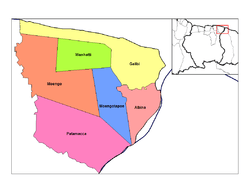 Map showing the resorts of Marowijne District. | |
 Wanhatti Map showing the resorts of Marowijne District. | |
| Coordinates: 5°48′N 54°27′W / 5.800°N 54.450°W | |
| Country |
|
| District | Marowijne District |
| Area | |
| • Total | 461 km2 (178 sq mi) |
| Elevation | 0 m (0 ft) |
| Population (2012) | |
| • Total | 466 |
| • Density | 1.0/km2 (2.6/sq mi) |
| Time zone | AST (UTC-3) |
Wanhatti is a town and resort in Suriname, located in the Marowijne district on the Cottica River.
Coordinates: 5°48′N 54°27′W / 5.800°N 54.450°W
| Brokopondo District |  | |
|---|---|---|
| Commewijne District | ||
| Coronie District | ||
| Marowijne District | ||
| Nickerie District | ||
| Para District | ||
| Paramaribo District | ||
| Saramacca District | ||
| Sipaliwini District | ||
| Wanica District | ||
This article is issued from Wikipedia - version of the 4/4/2014. The text is available under the Creative Commons Attribution/Share Alike but additional terms may apply for the media files.