Washington State Route 113
| ||||
|---|---|---|---|---|
| Burnt Mountain Road | ||||
|
SR 113 highlighted in red. | ||||
| Route information | ||||
| Auxiliary route of US 101 | ||||
| Defined by RCW 47.17.216 | ||||
| Maintained by WSDOT | ||||
| Length: | 9.98 mi[1] (16.06 km) | |||
| Existed: | 1991 (current route)[2] – present | |||
| Major junctions | ||||
| South end: |
| |||
| North end: |
| |||
| Highway system | ||||
| ||||


State Route 113 (SR 113, commonly called Burnt Mountain Road[1]) is a 9.98-mile (16.06 km) long Washington state highway in Clallam County on the Olympic Peninsula, extending from U.S. Route 101 (US 101) in Sappho to the south to SR 112 southeast of Clallam Bay. The current route was Secondary State Highway 9A (SSH 9A) from 1937 until 1955, when SSH 9A was rerouted along current SR 112. The roadway became SR 113 in 1991, after the former SR 113 was replaced by SR 20 in 1975, which was the Port Townsend branch of Primary State Highway 9 (PSH 9) and a branch of SSH 1D from 1937 until 1964, when it became SR 113.
Route description
State Route 113 (SR 113) begins at an intersection with U.S. Route 101 (US 101) in the community of Sappho, east of Lake Pleasant and north of the Sol Duc River. From the terminus, the roadway goes northeast crossing a railroad three times and Beaver Creek twice before arriving at Beaver Lake. From Beaver Lake, the highway travels north to SR 112 near the Pysht River and southeast of Clallam Bay, where it ends.[3] After the US 101 intersection in 2007, SR 113 had an estimated daily average of 1,000 motorists,[4] decreased from the estimated 1,500 motorists in 1992.[5]
History
The current route that SR 113 uses today was first state-maintained in 1937, during the creation of the Primary and secondary system as SSH 9A, extending from Sappho to Port Angeles.[6][7] The Sappho–Clallam Bay segment was dropped from SSH 9A in 1955 and SSH 9A instead extended west to Neah Bay.[8][9] SSH 9A later became SR 112 during the 1964 highway renumbering and SR 113 was assigned to a different route.[10] In 1991, SR 113 was given the current route from Sappho to Clallam Bay and no further alignment changes have since happened.[2][11][12]
Major intersections
The entire route is in Clallam County.
| Location | mi[1] | km | Destinations | Notes | |
|---|---|---|---|---|---|
| Sappho | 0.00 | 0.00 | |||
| | 9.98 | 16.06 | |||
| 1.000 mi = 1.609 km; 1.000 km = 0.621 mi | |||||
References
- 1 2 3 Washington State Department of Transportation (2006). "State Highway Log: Planning Report, SR 2 to SR 971" (PDF). Retrieved June 20, 2009.
- 1 2 Washington State Legislature (1991). "RCW 47.17.216: State route No. 113". Retrieved June 20, 2009.
- ↑ Google (June 20, 2009). "State Route 113" (Map). Google Maps. Google. Retrieved June 20, 2009.
- ↑ Washington State Department of Transportation (2007). "2007 Annual Traffic Report" (PDF). pp. 160–161, 95–96. Retrieved June 20, 2009.
- ↑ Washington State Department of Transportation (1992). "1992 Annual Traffic Report" (PDF). p. 106. Retrieved June 20, 2009.
- ↑ Washington State Legislature (1937). "Chapter 190: Establishment of Primary State Highways; Chapter 207: Classification of Public Highways". Session Laws of the State of Washington. Session Laws of the State of Washington (1937 ed.). Olympia, Washington: Washington State Legislature. pp. 938, 995, 1006. Retrieved June 20, 2009.
SEC. 9. A primary state highway to be known as Primary State Highway No. 9, or the Olympic Highway, is hereby established according to description as follows: Beginning at Olympia on Primary State Highway No. 1, thence in a westerly direction by the most feasible route by way of Elma, Montesano and Aberdeen to Hoquiam, thence in a northwesterly direction by the most feasible route by way of Lake Quinault to Forks, thence in an easterly direction by the most feasible route by way of Port Angeles to the vicinity of Discovery Bay, thence in a southerly direction by the most feasible route by way of Shelton to a junction with Primary State Highway No. 9, as herein described, in the vicinity west of Olympia; also beginning at a junction with Primary State Highway No. 9, as herein described, in the vicinity of Discovery Bay, thence in a northeasterly direction by the most feasible route to Port Townsend; also beginning at Elma on Primary State Highway No. 9, as herein described, thence in a southeasterly direction by the most feasible route to a junction with Primary State Highway No. 1, in the vicinity north of Centralia; also beginning at a junction with Primary State Highway No. 9, as herein described, at Montesano, thence in a southwesterly direction by the most feasible route to a junction with Primary State Highway No. 13 north of Arctic; (d) Secondary State Highway No. 1D; beginning at a junction with Primary State Highway No. 1 in the vicinity southeast of Anacortes, thence southerly by the most feasible route by way of Deception Pass to the vicinity of Columbia Beach in the southern portion of Whidbey Island; (a) Secondary State Highway No. 9A; beginning at Port Angeles on Primary State Highway No. 9, thence in a westerly direction by the most feasible route by way of the Pysht river to a junction with Primary State Highway No. 9 in the vicinity of Sappho.
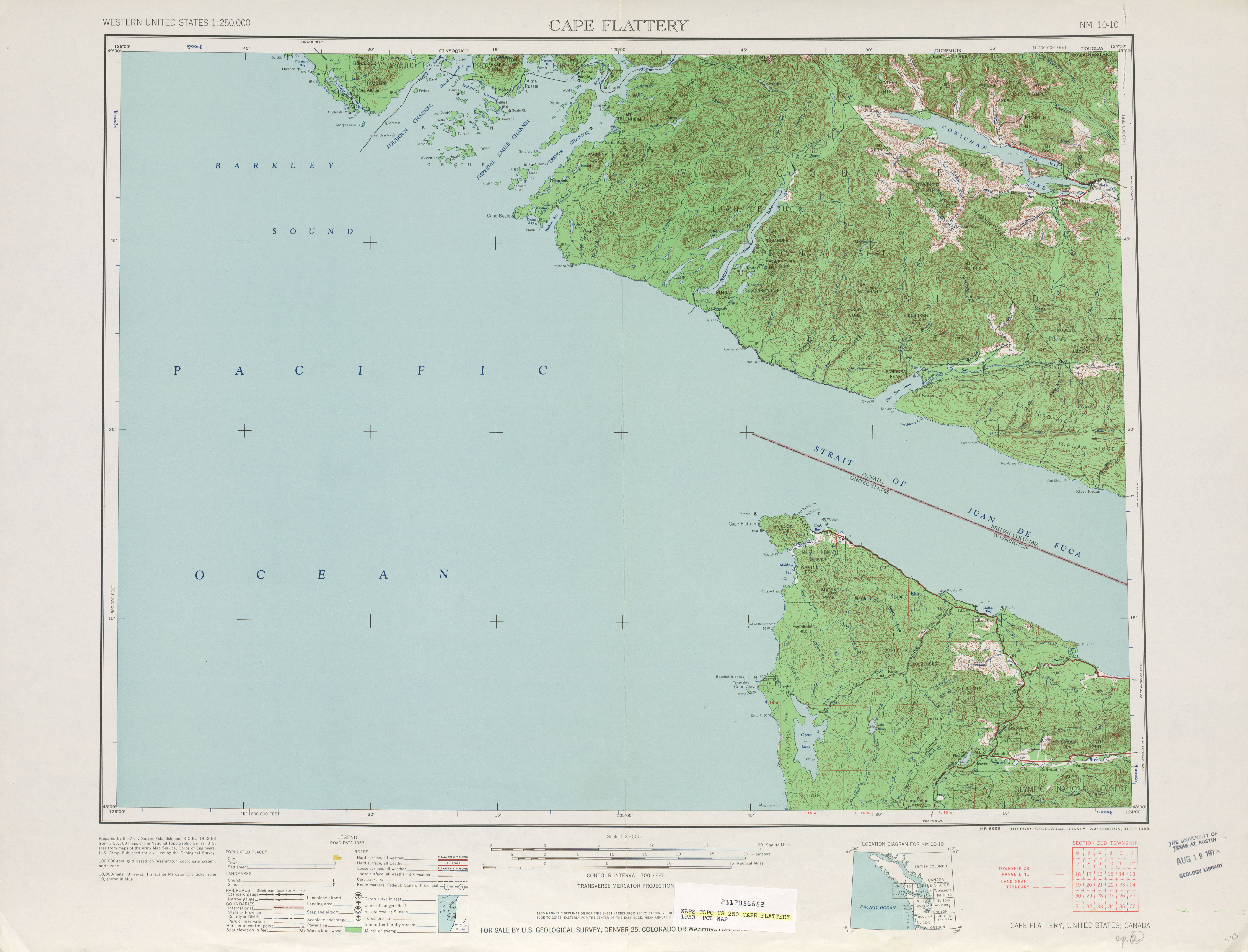
- ↑ United States Geological Survey (1953). Cape Flattery, 1953 (Map). 1:250,000. University of Texas at Austin. Retrieved June 20, 2009.
- ↑ Washington State Legislature (1955). "Chapter 383". Session Laws of the State of Washington. Session Laws of the State of Washington (1955 ed.). Olympia, Washington: Washington State Legislature.
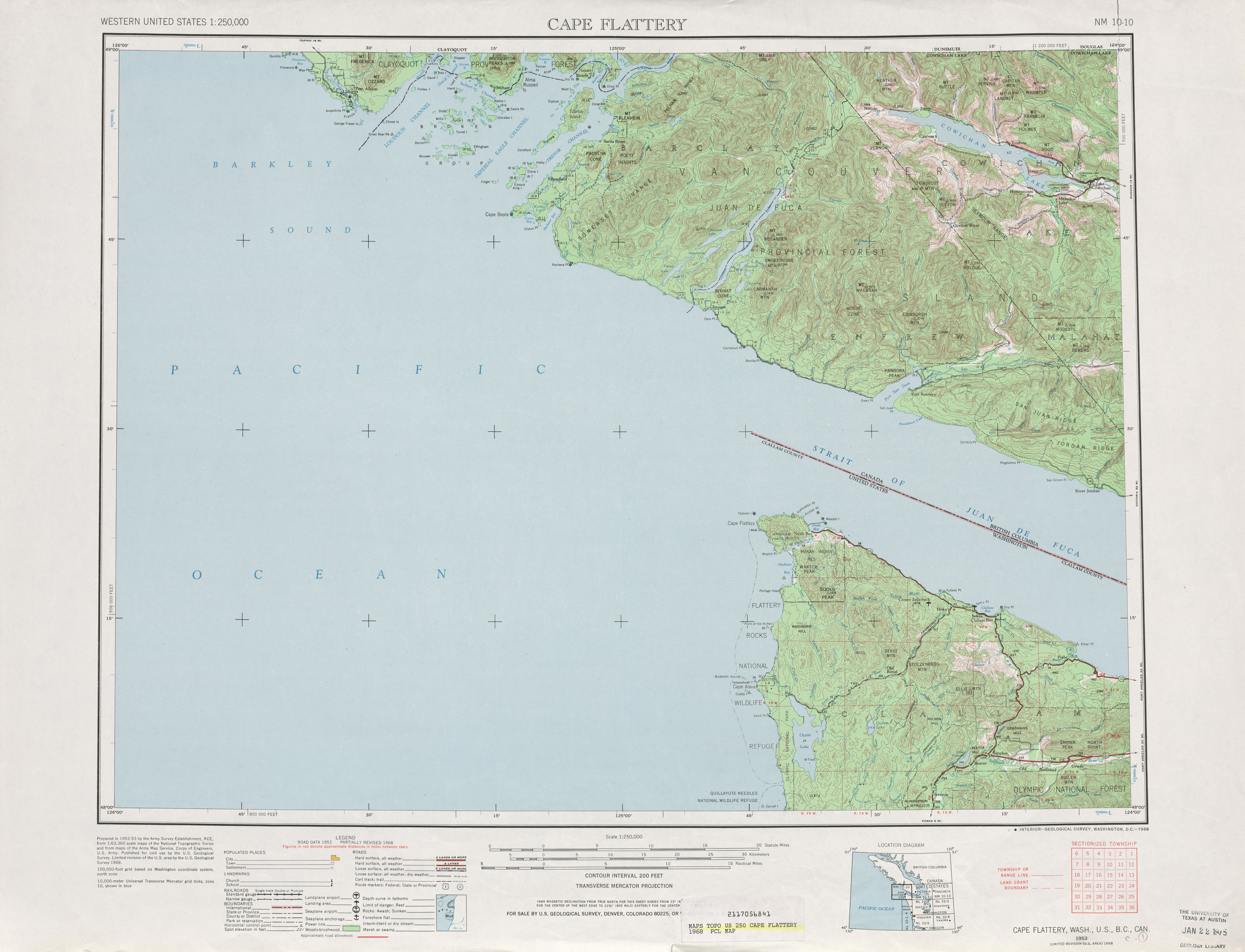
- ↑ United States Geological Survey (1968). Cape Flattery, 1968 (Map). 1:250,000. University of Texas at Austin. Retrieved June 20, 2009.
- ↑ C. G. Prahl (December 1, 1965). "Identification of State Highways" (PDF). Washington State Highway Commission, Department of Highways. Retrieved June 20, 2009.
- ↑ Washington House of Representatives (1991). "Chapter 342, Laws of 1991: State Highway Routes - Revisons To (House Bill 5801)". Washington State Legislature. Retrieved June 20, 2009.
NEW SECTION. Sec. 7. A state highway to be known as state route number 113 is established as follows: Beginning at a junction with state route number 101 in the vicinity of Sappho, thence northerly to a junction with state route number 112 in the vicinity of the Pysht River.
- ↑ Washington State Highways, 2008–2009 (PDF) (Map) (2008–09 ed.). 1:842,000. Cartography by United States Geological Survey. Washington State Department of Transportation. 2008. § C1. Retrieved June 20, 2009.
External links
Former or proposed State Routes: SR 111 | ||