Washington State Route 129
| ||||
|---|---|---|---|---|
 | ||||
| Route information | ||||
| Defined by RCW 47.17.260 | ||||
| Maintained by WSDOT | ||||
| Length: | 42.55 mi[1] (68.48 km) | |||
| Existed: | 1964[2] – present | |||
| Major junctions | ||||
| South end: |
| |||
| North end: |
| |||
| Highway system | ||||
| ||||

State Route 129 (SR 129) is a state highway in the U.S. state of Washington, located in Asotin County. It extends 42.55 miles (68.48 km) from Oregon Route 3 (OR 3) at the Oregon state line south of Anatone, Washington, north to U.S. Route 12 (US 12) in Clarkston, Washington.
SR 129 serves as a connecting road between Enterprise, Oregon and Clarkston and was originally part of Primary State Highway 3's Clarkston branch (PSH 3 DC) from 1937 until 1964, which ran from the Oregon state line to Dodge. PSH 3 DC was decommissioned in 1964, when a highway renumbering occurred, which created SR 129. SR 129 also has its own spur route located in Clarkston.
Route description
SR 129 is a highway that begins at OR 3 at the Oregon state line south of Anatone, Washington, and heads north to US 12 in Clarkston, serving as a link between the two towns.[3][4][5] The Washington State Department of Transportation (WSDOT) found that about 9,300 motorists use the road daily beyond its intersection with Sixth Street in Clarkston based on average annual daily traffic (AADT) data.[6]
From the Oregon state line, SR 129 travels north, then curves south before heading back north over the Grande Ronde River and going northeast past Fields Spring State Park and into the community of Anatone. After leaving Anatone, SR 129 continues northeast into Asotin. From the city, the road goes northeast as Riverside Drive and then begins to parallel the Snake River, which is the border between Washington and Idaho. Once SR 129 enters Clarkston, it breaks away from the Snake River and becomes known as 5th Street within Clarkston. After going northwest and becoming 6th Street, the road intersects SR 129 Spur and goes northeast as Diagonal Street.[7] As Diagonal Street, the highway ends at US 12, about 0.19 miles (0.31 km) away from the Lewiston – Clarkston Bridge, which carries US 12 across the Snake River into Lewiston, Idaho.[3][8]
SR 129 Spur
| |
|---|---|
| Location: | Clarkston |
| Existed: | 1970–present |
State Route 129 Spur (SR 129 Spur) runs 0.07 miles (0.11 km) from SR 129, north to US 12, within the City of Clarkston.[1] The route goes from SR 129, and merges onto westbound US 12.[7][9] It serves mostly as a cut through to and from the two routes and WSDOT has found that 2,300 motorists use the road daily near the SR 129 intersection.[6]
History
SR 129 began as part of Primary State Highway 3's Clarkston branch (PSH 3 DC) in 1937. PSH 3 DC traveled from OR 3 north to Clarkston and then west to Pomeroy, ending at PSH 3 where it was co-signed with U.S. Route 295 (US 295). US 295 was established in 1926, and later decommissioned in 1967.[10][11][12] In 1964, PSH 3 DC was renamed SR 129 and became a state highway during a statewide highway renumbering. The Washington State Department of Transportation (WSDOT) replaced the previous system of primary and secondary highways with a new system called State Routes, which is still in use today.[13][14]
Images
 SR 129 going north towards Asotin.
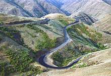 SR 129 in Joseph Canyon.
Major intersections
The entire highway is in Asotin County.
| Location | mi[1] | km | Destinations | Notes | |
|---|---|---|---|---|---|
| | 0.00 | 0.00 | Continuation beyond Oregon state line | ||
| | 40.83 | 65.71 | Southway Bridge - Fleshman Way | Interchange | |
| Clarkston | 42.17 | 67.87 | |||
| 42.55 | 68.48 | Northern terminus | |||
| 1.000 mi = 1.609 km; 1.000 km = 0.621 mi | |||||
References
- 1 2 3 Washington State Department of Transportation. "State Highway Log, 2006" (pdf). Retrieved September 24, 2008.
- ↑ Washington State Legislature. "RCW 47.17.260: State Route 129". Retrieved September 25, 2008.
- 1 2 Google (September 25, 2008). "State Route 129 Map" (Map). Google Maps. Google. Retrieved September 25, 2008.
- ↑ The Road Atlas (Map). Rand McNally. 2008. p. 109. § J20, K19, K20. ISBN 0-528-93961-0.
- ↑ Inland Empire (Map) (2007 ed.). G.M. Johnson. 2007. Retrieved September 26, 2008.
- 1 2 Washington State Department of Transportation (2007). "Washington Annual Average Daily Traffic Data" (PDF). Retrieved September 26, 2008.
- 1 2 Washington State Department of Transportation. "SR 129 / SR 129 Spur / US 12 Intersections" (PDF). Retrieved October 5, 2008.
- ↑ Clarkston, Lewiston, Pullman, Moscow (Map) (2006 ed.). G.M. Johnson. 2006. Retrieved September 26, 2008.
- ↑ Google (September 25, 2008). "State Route 129 Spur Map" (Map). Google Maps. Google. Retrieved September 25, 2008.
- ↑ Washington State Legislature (1937). "190". Session Laws of the State of Washington. Session Laws of the State of Washington (1937 ed.). Olympia, Washington: Washington State Legislature. Retrieved September 27, 2008.
- ↑ Bureau of Public Roads & American Association of State Highway Officials (November 11, 1926). United States System of Highways Adopted for Uniform Marking by the American Association of State Highway Officials (Map). 1:7,000,000. Washington, DC: U.S. Geological Survey. OCLC 32889555. Retrieved November 7, 2013 – via University of North Texas Libraries.
- ↑ Auto Road Atlas (Map). Rand McNally. 1926. Retrieved October 3, 2008.
- ↑ C. G. Prahl, Washington State Highway Commission (December 1, 1965). "Identification of State Highways, Part 1" (PDF). Retrieved September 25, 2008.
- ↑ C. G. Prahl, Washington State Highway Commission (December 1, 1965). "Identification of State Highways, Part 2" (PDF). Retrieved September 25, 2008.