Wazirpur Upazila
| Wazirpur উজিরপুর | |
|---|---|
| Upazila | |
 Wazirpur Location in Bangladesh | |
| Coordinates: 22°48.7′N 90°14.7′E / 22.8117°N 90.2450°ECoordinates: 22°48.7′N 90°14.7′E / 22.8117°N 90.2450°E | |
| Country |
|
| Division | Barisal Division |
| District | Barisal District |
| Area | |
| • Total | 248.35 km2 (95.89 sq mi) |
| Population (1991) | |
| • Total | 227,115 |
| • Density | 910/km2 (2,400/sq mi) |
| Time zone | BST (UTC+6) |
| Website | Official Map of the Wazirpur Upazila |
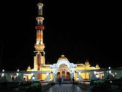
Baitul Aman Mosque, located in Guthia, Wazirpur
Wazirpur (Bengali: উজিরপুর) is an Upazila of Barisal District in the Division of Barisal, Bangladesh.[1]
Geography
Wazirpur is located at 22°48′40″N 90°14′40″E / 22.8111°N 90.2444°E. It has 44,480 households and a total area of 248.35 km².
Demographics
According to the 1991 Bangladesh census, Wazirpur had a population of 227,115. Males constituted 50.8% of the population, and females 49.2%. The number of residents aged 18 or over was 114,254. Wazirpur has an average literacy rate of 47.7% (7+ years), compared to the national average of 32.4%. There are 22 colleges and 50 primary schools in Wazirpur.[2]
Notable residents
- Major M. A. Jalil, freedom fighter and sector commander.
See also
References
- ↑ Md. Mizanur Rahman (2012). "Wazirpur Upazila". In Sirajul Islam and Ahmed A. Jamal. Banglapedia: National Encyclopedia of Bangladesh (Second ed.). Asiatic Society of Bangladesh.
- ↑ "Population Census Wing, BBS.". Archived from the original on 2005-03-27. Retrieved November 10, 2006.
| Upazila/Thana: | ||
|---|---|---|
Capital: Barisal | ||
| Barguna District |  | |
| Barisal District | ||
| Bhola District | ||
| Jhalokati District | ||
| Patuakhali District | ||
| Pirojpur District | ||
This article is issued from Wikipedia - version of the 9/9/2016. The text is available under the Creative Commons Attribution/Share Alike but additional terms may apply for the media files.