Wendell Town Common Historic District
|
Wendell Town Common Historic District | |
|
The town meetinghouse | |
  | |
| Location | Wendell, Massachusetts |
|---|---|
| Coordinates | 42°32′55″N 72°23′51″W / 42.54861°N 72.39750°WCoordinates: 42°32′55″N 72°23′51″W / 42.54861°N 72.39750°W |
| Architect | Leach,Luke O. |
| Architectural style | Colonial Revival, Greek Revival, Federal |
| NRHP Reference # | [1] |
| Added to NRHP | May 21, 1992 |
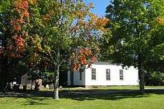
The Wendell Town Common Historic District encompasses the historic heart of the small town of Wendell, Massachusetts. Its town common, laid out in 1774, is a rectangular plot of land, about 1 acre (0.40 ha), bounded on the west by Lock's Village Road and Depot Road, is roughly bisected by Morse Village Road, and is bounded on its north, east, and south by Center Road. The sides of the roads opposite the common are lined with institutional buildings and houses that are predominantly in the Greek Revival style and date to the first half of the 19th century. The only contributing 20th-century building is the Colonial Revival library, built 1921.[2] The district was listed on the National Register of Historic Places in 1992.[1]
See also
References
- 1 2 National Park Service (2008-04-15). "National Register Information System". National Register of Historic Places. National Park Service.
- ↑ "MACRIS inventory record for Wendell Town Common". Commonwealth of Massachusetts. Retrieved 2013-12-19.
| Topics |  | ||||||||||||||||||||||||||||||
|---|---|---|---|---|---|---|---|---|---|---|---|---|---|---|---|---|---|---|---|---|---|---|---|---|---|---|---|---|---|---|---|
| Lists by county | |||||||||||||||||||||||||||||||
| Lists by city |
| ||||||||||||||||||||||||||||||
| Other lists | |||||||||||||||||||||||||||||||
| |||||||||||||||||||||||||||||||
This article is issued from Wikipedia - version of the 11/27/2016. The text is available under the Creative Commons Attribution/Share Alike but additional terms may apply for the media files.