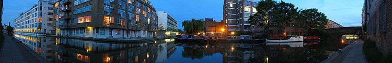
Wenlock Basin


Regents Canal Basins | |||||||||||||||||||||||||||||||||||||||||||||||||||||||||||||||||||||||||||||||||||||||||||||||||||||||||||||||||||||||||||||||||||||||||
|---|---|---|---|---|---|---|---|---|---|---|---|---|---|---|---|---|---|---|---|---|---|---|---|---|---|---|---|---|---|---|---|---|---|---|---|---|---|---|---|---|---|---|---|---|---|---|---|---|---|---|---|---|---|---|---|---|---|---|---|---|---|---|---|---|---|---|---|---|---|---|---|---|---|---|---|---|---|---|---|---|---|---|---|---|---|---|---|---|---|---|---|---|---|---|---|---|---|---|---|---|---|---|---|---|---|---|---|---|---|---|---|---|---|---|---|---|---|---|---|---|---|---|---|---|---|---|---|---|---|---|---|---|---|---|---|---|---|
| |||||||||||||||||||||||||||||||||||||||||||||||||||||||||||||||||||||||||||||||||||||||||||||||||||||||||||||||||||||||||||||||||||||||||
The Wenlock Basin, a canal basin, is part of the Regent's Canal in the London Borough of Hackney, just east of City Road Basin, on the other side of Wharf Road. It was constructed in 1826 and is close to the entrance of the Islington Tunnel, where a tug service operated until the 1930s.
There are private residential moorings[1] at the North end, with their own entrance gate and entryphone on Wharf Road. The basin itself narrows considerably towards the South - and is not deep enough to be navigable by anything other than canoe.
Unlike the Regent's Canal and City Road Basin, Wenlock Basin is not owned or managed by British Waterways.[2]
Residential developments
Wenlock Basin is accessible only to residents. The development consists of the following buildings:
- The Royle Building, one of the earliest schemes on the basin, originally the Royle printworks at the junction of the Regent’s Canal and Wenlock Basin. Converted to almost 100 loft apartments, and recently had 'Skypads' added to the roof. Next to the Royle Building on Regent's Canal is the art-deco style warehouse called The Canal Building, originally sold as 79 shells.
- Union Wharf,[3] A development of 90 loft-style apartments and live/work units designed and built by Persimmon Homes (Formerly the Beazer Group).[4]
- Estilo, A mixed-use development of 43 one, two and three-bedroom units overlooking Wenlock Basin completed in 2006 by Telford Homes.[5]
- Micawber Wharf, Another development of 18 studios, flats and live work/units completed in 2008. Designed by Stephen Davy Peter Smith Architects, and developed by Isotop.[6]
- The Wenlock Building, New mixed use development of 82 units on the west side of the basin at its junction with the Regent's Canal. Design by Johnson Naylor Architects, developed in a joint venture between Londonewcastle[7] and Modern City Living,[8] expected completion October 2008.[9]
Businesses
A number of businesses still operate on Wenlock Basin, either in the ground floor business units of the larger residential developments - or in their own property directly backing on to the basin. They include the Victoria Miro Gallery, a leading British contemporary art gallery in London run by Victoria Miro.
Gallery
See also
References
- ↑ Canal Museum: Advice on Moorings in London
- ↑ British Waterways, London: May 2008
- ↑ Union Wharf: Residents association
- ↑ Persimmon Homes: Property developers
- ↑ Telford Homes: Estilo Development
- ↑ Housing Design Awards 2008: Shortlisted Completed Schemes
- ↑ Londonewcastle: Property developer
- ↑ Modern City Living: Property developer
- ↑ Wenlock Building: Sales Website
External links
- Tuesday Night Club: a visit to Wenlock Basin
Coordinates: 51°31′56″N 0°05′45″W / 51.532349°N 0.095714°W