Westerhever
| Westerhever | |
|---|---|
 Westerhever | |
Location of Westerhever within Nordfriesland district  | |
| Coordinates: 54°23′N 8°40′E / 54.383°N 8.667°ECoordinates: 54°23′N 8°40′E / 54.383°N 8.667°E | |
| Country | Germany |
| State | Schleswig-Holstein |
| District | Nordfriesland |
| Municipal assoc. | Eiderstedt |
| Government | |
| • Mayor | Albert Pahl |
| Area | |
| • Total | 13.21 km2 (5.10 sq mi) |
| Population (2015-12-31)[1] | |
| • Total | 104 |
| • Density | 7.9/km2 (20/sq mi) |
| Time zone | CET/CEST (UTC+1/+2) |
| Postal codes | 25881 |
| Dialling codes | 04865 |
| Vehicle registration | NF |
| Website |
www.amt-eiderstedt. kommunen. nordfriesland. city-map.de |
Westerhever (Danish: Vesterhever) is a municipality in Nordfriesland in the German state of Schleswig-Holstein.
Geography

Aerial view of the Westerheversand Lighthouse
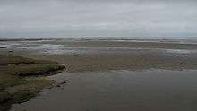
Westerhever lies on the northwestern tip of the Eiderstedt Peninsula. The Westerheversand Lighthouse is a major landmark on the peninsula which is surrounded by salt marshes. The saltmarshes, lighthouse, and beaches attract about 80,000 visitors every year.
History
The island Westerhever was first settled by humans in the 12th Century. The first humans there built a ring dike to protect the land.
External links
![]() Media related to Westerhever at Wikimedia Commons
Media related to Westerhever at Wikimedia Commons
References
This article is issued from Wikipedia - version of the 1/6/2016. The text is available under the Creative Commons Attribution/Share Alike but additional terms may apply for the media files.