Westfield Center Historic District
|
Westfield Center Historic District | |
|
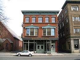
Rinnova Building | |
  | |
| Location | Westfield, Massachusetts |
|---|---|
| Coordinates | 42°7′22″N 72°44′55″W / 42.12278°N 72.74861°WCoordinates: 42°7′22″N 72°44′55″W / 42.12278°N 72.74861°W |
| NRHP Reference # | 08000506, 13000441[1] |
| Added to NRHP | June 10, 2008; expanded and renamed June 25, 2013 |
The Westfield Center Historic District is a historic district encompassing 157 acres (64 ha) of the civic, commercial, and industrial heart of Westfield, Massachusetts.[2] It represents a major expansion of the Westfield Center Commercial Historic District, which included only two blocks of buildings along Elm Street in downtown Westfield.[3] The district includes buildings representing the city's growth in the 19th century as a center of the whip-making industry, and its early years as a center for statewide educational institutions, as well as its growth as a regional center of western Hampden County.[2]
The commercial district was added to the National Register of Historic Places in 2008; the expansion and renaming of the district took place in 2013.[1] Buildings in the district that were previously listed on the National Register include the Sanford Whip Factory, the Westfield Whip Manufacturing Company, the United States Whip Company Complex, and the Westfield Municipal Building (formerly a building of the state's normal school, now city hall).
See also
References
- 1 2 National Park Service (2008-04-15). "National Register Information System". National Register of Historic Places. National Park Service.
- 1 2 "Westfield Center Historic District". National Park Service. Retrieved 2013-12-07.
- ↑ "NRHP nomination for Westfield Center Commercial Historic District". Commonwealth of Massachusetts. Retrieved 2013-12-07.
| Topics |  | ||||||||||||||||||||||||||||||
|---|---|---|---|---|---|---|---|---|---|---|---|---|---|---|---|---|---|---|---|---|---|---|---|---|---|---|---|---|---|---|---|
| Lists by county | |||||||||||||||||||||||||||||||
| Lists by city |
| ||||||||||||||||||||||||||||||
| Other lists | |||||||||||||||||||||||||||||||
| |||||||||||||||||||||||||||||||