Whately Center Historic District
|
Whately Center Historic District | |
|
Whately Town Hall | |
  | |
| Location | Whately, Massachusetts |
|---|---|
| Coordinates | 42°26′18″N 72°38′9″W / 42.43833°N 72.63583°WCoordinates: 42°26′18″N 72°38′9″W / 42.43833°N 72.63583°W |
| Architect | Damon, Isaac; et al. |
| Architectural style | Georgian, Federal |
| NRHP Reference # | [1] |
| Added to NRHP | September 11, 2003 |
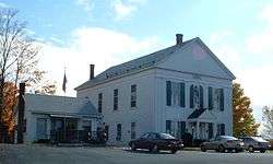
The Whately Center Historic District encompasses the historic rural village center of Whately, Massachusetts. Located in the hills west of the Connecticut River and north of Northampton, the district consists of a stretch of Chestnut Plain Road, the main north-south route through the village, and a short stretch of Haydenville Road, which is roughly at the center of the district. There are many fine homes from the Federal period, although they often have embellishments from later periods. Greek Revival architecture is also a major presence, with numerous houses, as well as the town's civic centerpieces, the town hall (c. 1844) and Second Congregational Church (c. 1843), showing that style. There are only a modest number of 20th century structures in the district bounds.[2] The district was listed on the National Register of Historic Places in 2003.[1]
See also
- National Register of Historic Places listings in Franklin County, Massachusetts
- West Whately Historic District
References
- 1 2 National Park Service (2008-04-15). "National Register Information System". National Register of Historic Places. National Park Service.
- ↑ "NRHP nomination for Whately Center Historic District". Commonwealth of Massachusetts. Retrieved 2013-12-19.
| Topics |  | ||||||||||||||||||||||||||||||
|---|---|---|---|---|---|---|---|---|---|---|---|---|---|---|---|---|---|---|---|---|---|---|---|---|---|---|---|---|---|---|---|
| Lists by county | |||||||||||||||||||||||||||||||
| Lists by city |
| ||||||||||||||||||||||||||||||
| Other lists | |||||||||||||||||||||||||||||||
| |||||||||||||||||||||||||||||||