White Island (Ross Archipelago)
Not to be confused with White Island (Enderby Land) or White Islands.
 White Island from Ross Sea | |
 White Island Location in Antarctica | |
| Geography | |
|---|---|
| Location | Antarctica |
| Coordinates | 78°8′S 167°24′E / 78.133°S 167.400°ECoordinates: 78°8′S 167°24′E / 78.133°S 167.400°E |
| Archipelago | Ross Archipelago |
| Administration | |
| Demographics | |
| Population | Uninhabited |
| Additional information | |
| Administered under the Antarctic Treaty System | |
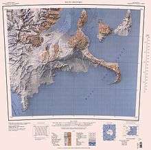
White Island is an island in the Ross Archipelago of Antarctica. It is 28 km (15 nmi) long, protruding through the Ross Ice Shelf immediately east of Black Island. It was discovered by the Discovery Expedition (1901–04) and so named by them because of the mantle of snow which covers it. Some 142 km2 of shelf ice adjoining the north-west coast of the island has been designated an Antarctic Specially Protected Area (ASPA 137) because it supports an isolated small breeding population of Weddell seals.[1]
See also
References
- ↑ "North-west White Island, McMurdo Sound" (PDF). Management Plan for Antarctic Specially Protected Area No. 137: Measure 9, Annex. Antarctic Treaty Secretariat. 2008. Retrieved 2013-09-21.
![]() This article incorporates public domain material from the United States Geological Survey document "White Island (Ross Archipelago)" (content from the Geographic Names Information System).
This article incorporates public domain material from the United States Geological Survey document "White Island (Ross Archipelago)" (content from the Geographic Names Information System).
This article is issued from Wikipedia - version of the 11/11/2016. The text is available under the Creative Commons Attribution/Share Alike but additional terms may apply for the media files.