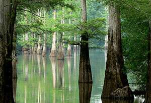
White River (Arkansas)
| White River | |
| River | |
 White River, 2008 | |
| Country | United States |
|---|---|
| States | Arkansas, Missouri |
| Tributaries | |
| - left | James River, North Fork River, Black River |
| - right | Buffalo River, Little Red River, Bayou des Arc |
| Cities | Newport, Batesville, Fayetteville |
| Source | Boston Mountains |
| - location | Ozark-St. Francis National Forest, Madison County, Arkansas |
| - elevation | 2,260 ft (689 m) [1] |
| - coordinates | 35°50′20″N 93°36′16″W / 35.83889°N 93.60444°W [2] |
| Mouth | Mississippi River |
| - location | Desha County, Arkansas |
| - elevation | 188 ft (57 m) [3] |
| - coordinates | 33°57′5″N 91°4′53″W / 33.95139°N 91.08139°WCoordinates: 33°57′5″N 91°4′53″W / 33.95139°N 91.08139°W [2] |
| Length | 722 mi (1,162 km) |
| Basin | 27,765 sq mi (71,911 km2) [4] |
| Discharge | for Devalls Bluff |
| - average | 26,180 cu ft/s (741 m3/s) [5] |
| - max | 154,000 cu ft/s (4,361 m3/s) |
| - min | 3,230 cu ft/s (91 m3/s) |
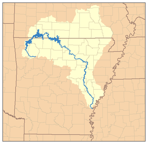 Map of the White River watershed | |
The White River is a 722-mile (1,162-km) long river that flows through the U.S. states of Arkansas and Missouri.
Course
The source of the White River is in the Boston Mountains of northwest Arkansas, in the Ozark–St. Francis National Forest southeast of Fayetteville. The river flows northwards from its source in northwest Arkansas, loops up through southwest Missouri through Branson, Missouri. In Branson the river is actually Lake Taneycomo since it is held back by the Powersite Dam.[6] The Powersite was the first dam on the White River. The flow into this comes from Table Rock Lake and down stream flows into Bull Shoals Lake where it travels back into Arkansas, and then heads generally southeast to its mouth at the Mississippi River.
On entering the Mississippi River Delta region near Batesville, Arkansas, the river becomes navigable to shallow-draft vessels, and its speed decreases considerably. The final 10 miles (16 km) of the river serves as the last segment of the McClellan-Kerr Arkansas River Navigation System; this part of the channel is deeper than the rest of the river.
Despite being much shorter than the Arkansas River, it carries nearly as much water—normally more than 20,000 cubic feet per second (570 m3/s), and occasionally more than 100,000 cubic feet per second (2,800 m3/s) during floods.
River modifications
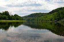
Lake Taneycomo was created in 1913 when the Empire District Electric Company built a dam just south of Forsyth, Missouri.[7] Beaver Lake, Bull Shoals Lake, and Table Rock Lake are man-made lakes or reservoirs created by the U.S. Army Corps of Engineers under the authority of the Flood Control Act of 1938.[8] A total of eight dams impound the upper White River, six in Arkansas and two in Missouri. The White River National Wildlife Refuge lies along the lower part of the river.
Tributaries
The tributaries of the White River include Cache River, Bayou des Arc, Little Red River, Black River, North Fork River, Buffalo River, Kings River, James River, and Roaring River. Some cities that lie on the White River are Newport, Augusta, Calico Rock, and Batesville, all in Arkansas, as well as Branson and Hollister in Missouri.
Angling
Fishing for trout is popular in the upper portions of the river from the Beaver Lake tailwaters in northwestern Arkansas, through its course through southwest Missouri(including all of Lake Taneycomo), and back down through Arkansas to the Highway 58 bridge in Guion. The river has long been ranked one of the top trout fisheries in the country. Fishing is popular in these waters for a number of trout species including rainbow, brown, and cutthroat trout.[9] A number of trout fishing resorts lie on the tailwaters of Bull Shoals Lake and the North Fork River.[10] Fishing for white bass is also popular in these waters.
See also
| Wikimedia Commons has media related to White River (Arkansas). |
- Cotter Bridge
- Grand Prairie Area Demonstration Project
- List of Arkansas rivers
- List of longest rivers of the United States (by main stem)
- List of Missouri rivers
- Whitewater Development Corporation
- White River Monster
References
- ↑ Google Earth elevation for GNIS source coordinates.
- 1 2 U.S. Geological Survey Geographic Names Information System: White River, USGS GNIS.
- ↑ Google Earth elevation for GNIS mouth coordinates.
- ↑ Availability of the Draft Environmental Impact Statement for the White River Minimum Flow Reallocation Study, AR | Federal Register Environmental Documents | USEPA
- ↑ http://pubs.usgs.gov/wdr/2005/wdr-ar-05/WDR-AR-05-1.pdf USGS Water Data Reports for the United States, 2005.
- ↑ "Branson Lake Taneycomo". Retrieved 25 August 2014.
- ↑ Pfister, Fred (2006). Insider's Guide: Branson and the Ozark Mountains. ISBN 0-7627-4042-6.
- ↑ Flood Control Act of 1938
- ↑ http://www.agfc.com/resources/GuidebookDocs/troutcomplete.pdf
- ↑ http://whiteriver.net/
- Cushing, Charles Phelps (August 1911). "Floating Through The Ozarks". The Outing Magazine. LVIII (5): 537–547. Retrieved 2009-08-16.