Whitman, Massachusetts
| Whitman, Massachusetts | ||
|---|---|---|
| Town | ||
|
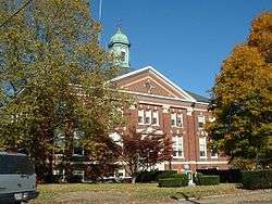
Whitman Town Hall | ||
| ||
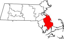
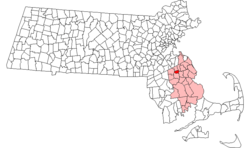 Location in Plymouth County in Massachusetts | ||
| Coordinates: 42°04′50″N 70°56′10″W / 42.08056°N 70.93611°WCoordinates: 42°04′50″N 70°56′10″W / 42.08056°N 70.93611°W | ||
| Country | United States | |
| State | Massachusetts | |
| County | Plymouth | |
| Settled | 1670 | |
| Incorporated | 1875 | |
| Government | ||
| • Type | Open town meeting | |
| Area | ||
| • Total | 7.1 sq mi (18.1 km2) | |
| • Land | 7.0 sq mi (18.0 km2) | |
| • Water | 0.0 sq mi (0.0 km2) | |
| Elevation | 110 ft (34 m) | |
| Population (2010) | ||
| • Total | 14,489 | |
| • Density | 2,069.9/sq mi (804.9/km2) | |
| Time zone | Eastern (UTC-5) | |
| • Summer (DST) | Eastern (UTC-4) | |
| ZIP code | 02382 | |
| Area code(s) | 339 / 781 | |
| FIPS code | 25-79530 | |
| GNIS feature ID | 0618355 | |
| Website | www.whitman-ma.gov | |
Whitman is a town in Plymouth County, Massachusetts, United States. The population was 14,489 at the 2010 census. It is notable as being the place where the chocolate chip cookie was invented.
History
Whitman was first settled by Europeans in 1670 and was officially incorporated in 1875. Prior to becoming Whitman, it was formally the southern parish of the town of Abington. The new name, Whitman, was taken from Augustus Whitman,[1] whose family who grew up in South Abington, and was adopted in 1886. Though before adopting the name Whitman, the small town was known as Little Comfort.
Whitman has a rich history that is deeply rooted in the shoemaking industry. Regal Shoe and Bostonian Shoe are perhaps the most notable. At one time there were over 20 shoe factories and related factories making metal shanks in town. There are a few abandoned factories left, and some have been turned into condominiums.
In the late 1930s, Ruth Graves Wakefield invented chocolate chip cookies in Whitman at the Toll House Inn on Bedford Street.[2] The Toll House burned completely on New Year's Eve 1984, in a fire that originated in the kitchen. The inn was not rebuilt. The site is marked with a historical marker, and that land is now home to a Wendy's restaurant and Walgreens pharmacy, with the Toll House sign still in existence. The former Whitman Savings Bank was also the first in the country to offer savings bank life insurance (SBLI). Whitman is the home of the famous Peaceful Meadows Ice Cream, as well as the former home of Saftler's Inc., one of the oldest and largest independently owned fabric stores in the country, which closed in June 2011.[3] In 1964 The Venus Cafe was founded by former professional wrestler Peter Drosos, who fought under the name Pete "The Golden Greek".
From 1968 to 1994, Whitman was also home to King's Castle Land, a children's amusement park owned by the Whitney family and located near the intersection of Routes 18 and 14.[4]
Geography
According to the United States Census Bureau, the town has a total area of 7.0 square miles (18 km2), of which 7.0 square miles (18 km2) is land and 0.14% is water. Statistically, the town is the 327th of 351 communities in the Commonwealth by land area, and is the second smallest (above only Hull) in Plymouth County. Whitman is bordered by Abington to the north, Rockland to the northeast, Hanson to the southeast, East Bridgewater to the south, and the city of Brockton to the west. Whitman's town center is approximately 4.5 miles (7.2 km) east of the center of Brockton and approximately 20 miles (32 km) south of Boston.
The small town today is mostly residential, with a small town forest in the northeast corner of town. The eastern half of the town is divided by the Shumatuscacant River, which is dammed near the town center at the site of the town's mills. The eastern half of town is also dominated by two meadows, the Hobart Meadow to the north and the Bear Meadow to the south, both along the banks of the river.
Transportation
The center of town is about half a mile to the east of the intersection of Route 18 and Route 27, the actual center of town being at the intersection of Route 27 and Washington Street. Route 14 also intersects with Route 18, about three quarters of a mile south of the intersection of Routes 27 and 18. Route 58 also crosses through the eastern corner of town. There are no interstates or divided highways in town; the nearest highway is Route 24 which passes through Brockton.
Whitman has a stop, located on Route 27, along the Kingston-Route 3 route of the MBTA's commuter rail. The rail, formerly the Old Colony Line, passes through the eastern half of town, east of the mill ponds and meadows. There is no air service to the town; the nearest international air service can be reached at Logan International Airport in Boston, 26 miles north of Whitman.
Demographics
| Historical population | ||
|---|---|---|
| Year | Pop. | ±% |
| 1880 | 3,024 | — |
| 1890 | 4,441 | +46.9% |
| 1900 | 6,155 | +38.6% |
| 1910 | 7,292 | +18.5% |
| 1920 | 7,147 | −2.0% |
| 1930 | 7,638 | +6.9% |
| 1940 | 7,759 | +1.6% |
| 1950 | 8,413 | +8.4% |
| 1960 | 10,485 | +24.6% |
| 1970 | 13,059 | +24.5% |
| 1980 | 13,534 | +3.6% |
| 1990 | 13,240 | −2.2% |
| 2000 | 13,882 | +4.8% |
| 2010 | 14,489 | +4.4% |
| * = population estimate. Source: United States Census records and Population Estimates Program data.[5][6][7][8][9][10][11] | ||
As of the census[12] of 2000, there were 13,882 people, 4,999 households, and 3,604 families residing in the town. The population density was 1,995.7 people per square mile (770.1/km²). There were 5,104 housing units at an average density of 733.8 per square mile (283.1/km²). The racial makeup of the town was 97.15% White, 0.65% African American, 0.16% Native American, 0.43% Asian, 0.01% Pacific Islander, 0.48% from other races, and 1.12% from two or more races. Hispanic or Latino of any race were 0.88% of the population.
There were 4,999 households out of which 36.8% had children under the age of 18 living with them, 56.5% were married couples living together, 11.6% had a female householder with no husband present, and 27.9% were non-families. 22.4% of all households were made up of individuals and 8.0% had someone living alone who was 65 years of age or older. The average household size was 2.77 and the average family size was 3.30.
In the town the population was spread out with 26.7% under the age of 18, 8.4% from 18 to 24, 33.6% from 25 to 44, 21.8% from 45 to 64, and 9.5% who were 65 years of age or older. The median age was 35 years. For every 100 females there were 96.4 males. For every 100 females age 18 and over, there were 93.1 males.
The median income for a household in the town was $55,303, and the median income for a family was $63,706. Males had a median income of $41,950 versus $30,629 for females. The per capita income for the town was $23,002. About 2.0% of families and 3.3% of the population were below the poverty line, including 2.8% of those under age 18 and 8.0% of those age 65 or over.
Statistically, Whitman is the 133rd largest community by population and 52nd most densely populated in the state. On average, Whitman's population is below the average but above the median, and its population density is well above the state average.
Government
On the national level, Whitman is a part of Massachusetts's 9th congressional district, and has been represented since 2001 by Stephen Lynch. The state's senior (Class I) senator, elected in 2012, is Elizabeth Warren. The junior (Class II) member of the United States Senate is Ed Markey. Markey was elected in 2013 to finish out the remainder of the term vacated by John Kerry when he became Secretary of State.
On the state level, Whitman is represented in the Massachusetts House of Representatives as a part of the Seventh Plymouth district, which includes the towns of Abington and East Bridgewater. Current State Rep is Whitman resident Geoff Diehl. The town is represented in the Massachusetts Senate as a part of the Second Plymouth and Bristol district, which includes Brockton, Halifax, Hanover, Hanson and portions of East Bridgewater and Easton.[13] The town is patrolled by the First (Norwell) Barracks of Troop D of the Massachusetts State Police.[14]
Whitman is governed by the open town meeting form of government, and is led by a town manager and a board of selectmen. The town's police department is located in a newly constructed building on a site formerly used for a succession of schools.[15] The town's fire department is located further west along Route 27. It has its own ambulance service, and patients needing emergency care are brought to Brockton Hospital, Good Samaritan Hospital in Brockton or South Shore Hospital in South Weymouth. The town's post office is located just east of the town hall. The Whitman Public Library is located a block south of Route 27, having moved into its first stand-alone branch in 1982 after seventy-five years in the town hall. Between the library and the fire department is a National Guard armory. The town also operates a playground and pool at the Whitman town park (which was designed by the Olmsted Brothers firm), just north of the town hall.
Education
Since the mid-1960s, Whitman has been paired with Hanson as a part of what was the Whitman-Hanson Regional High School School District but later joined as Whitman-Hanson Regional School District with the addition of the elementary and middle schools. There are two elementary schools in town; the Duval and Conley Schools (in the east and west parts of town, respectively), which serve students from kindergarten through fifth grade. The Whitman Middle School, located south of Route 27 in the western part of town, serves students from sixth to eighth grades. Students from both Whitman and Hanson attend Whitman-Hanson Regional High School, located along Route 27 on the Hanson side of the road. Students moved into the new, more technologically advanced school building in 2005 from the previous school, which was closer to the road (the former Whitman-Hanson High School is no longer standing and its old location is now home to athletic fields.) Whitman-Hanson's teams are known as the Panthers, and their colors are red and black. One of their chief rivals is nearby Abington, whom they play in the annual Thanksgiving Day football game. In 2010, Whitman-Hanson played the 100th anniversary game against Abington.[16] Whitman-Hanson leads the series 59-43-3 through the 2015 season, although Abington has won 11 of the last 14.[17]
In addition to Whitman-Hanson, students may choose to attend South Shore Regional Vocational Technical High School in Hanover free of charge. There are no private schools in the town, but both Hanson and Brockton have private schools. The nearest college is Massasoit Community College in neighboring Brockton.
Notable people
- Lennie Baker, of the doo wop band Sha Na Na
- Sean Conover, defensive end for the St. Louis Rams of the National Football League
- Alex Karalexis, a professional fighter who competed in the Ultimate Fighting Championship, World Extreme Cagefighting and was an original cast member on Season 1 of The Ultimate Fighter, The Ultimate Fighter 1
- Dana LeVangie, former baseball player and current bullpen coach for the Boston Red Sox
- James Lowder, editor and fantasy/horror author
- Harry Markopolos, unheeded whistleblower to the U.S. Securities and Exchange Commission of suspected securities fraud by Bernard Madoff
- Steve Smith, drummer of the rock band Journey as well as many jazz/fusion projects
- Francis Spellman, cardinal, ninth Bishop and sixth Archbishop of the Roman Catholic Archdiocese of New York
- Ruth Wakefield, creator of the Toll House Cookie
References
- ↑ "Profile for Whitman, Massachusetts". ePodunk. Retrieved 2010-04-27.
- ↑ "Inventor of the Week: Archive". Massachusetts Institute of Technology. Retrieved 2011-09-14.
- ↑ Lambert, Lane (June 3, 2011). "Saftler's fabric store, a Whitman landmark, to close at end of June". The Patriot Ledger. Quincy, Mass. Retrieved 2011-09-14.
- ↑ "King's Castle Land". Retrieved 2011-09-15.
- ↑ "TOTAL POPULATION (P1), 2010 Census Summary File 1, All County Subdivisions within Massachusetts". United States Census Bureau. Retrieved September 13, 2011.
- ↑ "Massachusetts by Place and County Subdivision - GCT-T1. Population Estimates". United States Census Bureau. Retrieved July 12, 2011.
- ↑ "1990 Census of Population, General Population Characteristics: Massachusetts" (PDF). US Census Bureau. December 1990. Table 76: General Characteristics of Persons, Households, and Families: 1990. 1990 CP-1-23. Retrieved July 12, 2011.
- ↑ "1980 Census of the Population, Number of Inhabitants: Massachusetts" (PDF). US Census Bureau. December 1981. Table 4. Populations of County Subdivisions: 1960 to 1980. PC80-1-A23. Retrieved July 12, 2011.
- ↑ "1950 Census of Population" (PDF). 1: Number of Inhabitants. Bureau of the Census. 1952. Section 6, Pages 21-10 and 21-11, Massachusetts Table 6. Population of Counties by Minor Civil Divisions: 1930 to 1950. Retrieved July 12, 2011.
- ↑ "1920 Census of Population" (PDF). Bureau of the Census. Number of Inhabitants, by Counties and Minor Civil Divisions. Pages 21-5 through 21-7. Massachusetts Table 2. Population of Counties by Minor Civil Divisions: 1920, 1910, and 1920. Retrieved July 12, 2011.
- ↑ "1890 Census of the Population" (PDF). Department of the Interior, Census Office. Pages 179 through 182. Massachusetts Table 5. Population of States and Territories by Minor Civil Divisions: 1880 and 1890. Retrieved July 12, 2011.
- ↑ "American FactFinder". United States Census Bureau. Retrieved 2008-01-31.
- ↑ Index of Legislative Representation by City and Town, from Mass.gov
- ↑ Station D-1, SP Norwell
- ↑ "Police Department Webpage". Retrieved 2014-02-26.
- ↑ "Rivalry reaches 100 years". Boston.com. Retrieved 2014-05-21.
- ↑ "H.S. FOOTBALL: Smith powers Whitman-Hanson past Abington". The Enterprise (Brockton). Retrieved 2016-04-21.
External links
| Wikimedia Commons has media related to Whitman, Massachusetts. |
| Wikisource has the text of the 1905 New International Encyclopedia article Whitman. |
- Town of Whitman official website
- Whitman Public Library
- Peaceful Meadows Ice Cream
- Answer Book/Whitman: Everything you need to know
 "Whitman". Encyclopedia Americana. 1920.