Wigginton, Staffordshire
| Wigginton | |
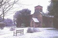 St Leonard's Church, Wigginton |
|
 Wigginton |
|
| OS grid reference | SK208067 |
|---|---|
| Civil parish | Wigginton and Hopwas |
| District | Lichfield |
| Shire county | Staffordshire |
| Region | West Midlands |
| Country | England |
| Sovereign state | United Kingdom |
| Post town | TAMWORTH |
| Postcode district | B79 |
| Dialling code | 01827 |
| Police | Staffordshire |
| Fire | Staffordshire |
| Ambulance | West Midlands |
| EU Parliament | West Midlands |
| UK Parliament | Tamworth |
|
|
Coordinates: 52°39′30″N 1°41′30″W / 52.6583°N 1.6917°W
Wigginton is a village in the district of Lichfield, in Staffordshire, England. The population as taken at the 2011 census can be found under Tamworth. It lies about 2 miles (3 km) north of Tamworth.
History
The name Wigginton is believed to come from Old English, and to mean Wicga's farm.[1] The name was also sometimes written as Wiggington.
The village lies on a medieval trade route, the Portway, possibly used for transporting salt from the River Mease at Edingale to Tamworth.[2]
Ecclesiastically Wigginton had been a chapelry attached to the parish of St Editha in Tamworth. For civil government it had been a township – the township was more than just the village, and included the hamlets of Comberford and Coton, the latter now part of the borough of Tamworth. In 1866 the township became a civil parish, and became part of Tamworth Rural District in 1894. In 1934 the civil parish was extended to become Wigginton and Hopwas, and became part of Lichfield Rural District.[3][4][5]
In 1861 the population of Wigginton township was 670, on 3,470 acres (1,400 ha). The population figure included 84 inmates of the Tamworth workhouse, which at that time lay within the township. The population of the chapelry alone was 466.[5]
Landmarks
Grade II listed buildings in Wigginton village include two or three houses, and the Church of St Leonard.[6] The former Anglican chapel, now a church, was rebuilt in 1777, extended in 1830,[7] and altered again in 1861 to a design by Nicholas Joyce.[8] Situated within the modern village is a shrunken medieval village, denoted by a series of pronounced earthworks to the northern end of the village, and medieval ridge and furrow still clearly visible in surrounding fields. To the south west of the village is the former site, now ploughed out, of a likely bronze age barrow, formerly known as "Robin Hood's Butt". Several finds of archaeological interest have been made in the area around the village: to the North West, is a flat space formerly called the "Money Lands", where human bones and ancient coins, thought to be Roman, were recovered in a find made in the 18th Century.[9]
Amenities
The village contains a pub, the Old Crown, and a Church of England primary school, St Leonard's.[10]
Note that the pub called The Wigginton is over the boundary in Tamworth, as is Wigginton Park, the home of Tamworth RUFC.
Notable people
Wigginton was the birth place of Samuel Parkes (c.1815-1864), a Private in the 4th Light Dragoons who won the Victoria Cross in the Charge of the Light Brigade for saving the life of Trumpeter Hugh Crawford of his regiment.[11] He was the son of Thomas Park(e)s and Lydia Fearn, who are buried in the churchyard of St Editha's, Tamworth. Samuel was baptised at St Editha's on 24 December 1815 and before enlistment in 1831 worked locally as an agricultural labourer.
References
- ↑ "Key to English Place Names". Institute for Name-Studies. Retrieved 29 September 2009.
- ↑ "Measham and the Mease Valley to 1300 AD - Salt Ways". Archived from the original on 29 September 2007. Retrieved 16 September 2009.
- ↑ "Wigginton". Online Gazetteer. Staffordshire County Council. 22 April 2009. Retrieved 11 October 2009.
- ↑ "GENUKI: Hopwas Hays". 17 October 2003. Retrieved 16 September 2009.
- 1 2 "A Vision of Britain". University of Portsmouth. Retrieved 12 October 2009.
- ↑ "Listed buildings of Wigginton and Hopwas CP" (PDF). Lichfield District Council. Retrieved 10 October 2009.
- ↑ "GENUKI: Tamworth". 19 July 2007. Retrieved 11 October 2009.
- ↑ "Wigginton S.Leonard". A church near you. Church of England. Retrieved 12 October 2009.
- ↑ Pitt, William (1817). A topographical history of Staffordshire...
- ↑ "St Leonard's C of E (A) Primary School". Retrieved 16 September 2009.
- ↑ "Call to remember Tamworth soldier". 2 August 2009.
| Wikimedia Commons has media related to Wigginton. |