Willamette Floodplain
| Willamette Floodplain | |
|---|---|
|
Grassland of the Willamette Floodplain | |
 | |
| Location | Benton County, Oregon, US |
| Nearest city | Corvallis |
| Coordinates | 44°24′49″N 123°17′57″W / 44.41352°N 123.29917°WCoordinates: 44°24′49″N 123°17′57″W / 44.41352°N 123.29917°W |
| Area | 713 acres (289 ha) |
| Designated | 1987 |
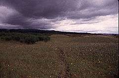
The Willamette Floodplain consists of 713 acres (289 ha) of natural grassland, near the Willamette River, that was made a National Natural Landmark in May 1987.[1] The floodplain is within the William L. Finley National Wildlife Refuge and located about 10 miles (16 km) south of Corvallis in Benton County, Oregon.
It is the largest remaining native unplowed example of bottomland interior valley grassland in the North Pacific Border natural region. It was classified as a natural landmark because such grassland and shrubland areas are exceedingly rare, with most having been cultivated or turned into pastureland.
References
- ↑ "Willamette Floodplain". National Park Service. March 31, 2011. Retrieved April 11, 2011.
External links
- Map of William L. Finley National Wildlife Refuge. U.S. Fish and Wildlife Service
This article is issued from Wikipedia - version of the 11/13/2016. The text is available under the Creative Commons Attribution/Share Alike but additional terms may apply for the media files.