Willapa River
| Willapa River | |
| Country | United States |
|---|---|
| State | Washington |
| County | Pacific |
| Source | Willapa Hills |
| - coordinates | 46°29′50″N 123°24′47″W / 46.49722°N 123.41306°W [1] |
| Mouth | Willapa Bay |
| - elevation | 0 ft (0 m) [1] |
| - coordinates | 46°42′27″N 123°51′2″W / 46.70750°N 123.85056°WCoordinates: 46°42′27″N 123°51′2″W / 46.70750°N 123.85056°W [1] |
| Length | 20 mi (32 km) |
| Discharge | for river mile 17.8, near Willapa, WA |
| - average | 636 cu ft/s (18.0 m3/s) [2] |
| - max | 12,800 cu ft/s (362.5 m3/s) |
| - min | 14 cu ft/s (0.4 m3/s) |
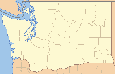 Location of the mouth of the Willapa River in Washington | |
The Willapa River is a river on the Pacific coast of southwestern Washington in the United States, approximately 20 miles (32 km) long. It drains an area of low hills and a coastal plain into Willapa Bay, a large estuary north of the mouth of the Columbia River.
The river rises in the Willapa Hills in southeastern Pacific County, approximately 25 miles (40 km) west of Chehalis. It flows northwest in a winding course past the small communities of Willapa and Raymond. It enters the northwest end of Willapa Bay at South Bend.
Name
The name is that of the Willapa people, an Athapaskan-speaking people, now extinct, who occupied the valley of the river and also the prairies between the headwaters of the Chehalis and Cowlitz Rivers.[3] River has miocene fossils.
See also
References
- 1 2 3 U.S. Geological Survey Geographic Names Information System: Willapa River
- ↑ "Water Resources Data-Washington Water Year 2005; Naselle and Willapa River Basins; USGS 12013500 Willapa River near Willapa, WA" (PDF). United States Geological Survey. Retrieved 2009-05-16.
- ↑ Curtis, Edward S. The North American Indian. Volume 9 - The Salishan tribes of the coast. The Chimakum and the Quilliute. The Willapa. pp. 141–142. ISBN 978-0-7426-9809-3.