Wirek
| Wirek | |
|---|---|
| Ruda Śląska District | |
|
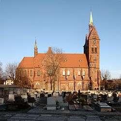
Saint Lawrence church | |
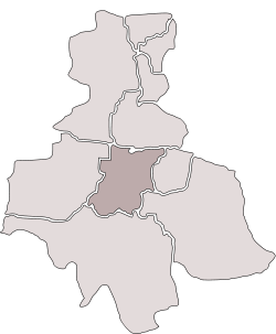 Location of Wirek within Ruda Śląska | |
| Coordinates: 50°16′28″N 18°51′52″E / 50.27444°N 18.86444°ECoordinates: 50°16′28″N 18°51′52″E / 50.27444°N 18.86444°E | |
| Country |
|
| Voivodeship | Silesian |
| County/City | Ruda Śląska |
| Time zone | CET (UTC+1) |
| • Summer (DST) | CEST (UTC+2) |
| Area code(s) | (+48) 032 |
Wirek (German: Antonienhütte) is a district in the centre of Ruda Śląska, Silesian Voivodeship, southern Poland. In 2006 it had an area of 5.9 km2 and was inhabited by 20,595 people.[1] On January 12, 2006 a part of it was split off to form a new district, Czarny Las.
History
Originally, the area belonged to Kochłowice. First a settlement called Nowa Wieś (lit. New Village) was established. Wirek would later developed around Antonienhütte ironworks, opened in 1805, and became a separate municipality in 1828. In the second half of the nineteenth century, the settlement grew owing to industrial development. A school was opened in 1856; a Roman Catholic church in 1874; and a year later, a rail connection with Chebzie was constructed. The municipality lost its independence in 1870.
In 1921, Wirek became part of Polish Autonomous Silesian Voivodeship. In 1924 Nowa Wieś again absorbed Wirek. A town hall was built in years 1929-1930. During World War II, it was occupied by Germany. In 1948 Nowa Wieś was renamed to Wirek.[2]
Wirek was merged into Nowy Bytom in 1951,[3] and as part of Nowy Bytom was amalgamated with Ruda to form Ruda Śląska on December 31, 1958.[4]
Notable residents
Gallery
 Mail office
 Saint Lawrence church
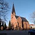 Lutheran church
 Synagogue, destroyed in 1939
References
- ↑ "Tab. 47 Rozkład dysfunkcji w mieście w latach 2003-2006". Lokalny Program Rewitalizacji Miasta Ruda Śląska na lata 2007-2015 (PDF) (in Polish). Ruda Śląska: Urząd Miasta Ruda Śląska. September 2007. p. 52.
- ↑ Rozporządzenie Ministra Administracji Publicznej z dnia 9 grudnia 1947 r. o zmianie nazw miejscowości: "Bojanowo Stare" w powiecie kościańskim, woj. poznańskim, na "Stare Bojanowo", "Nowa Wieś" w pow. katowickim, woj. śląskim, na "Wirek", "Wyzendorf Stary" w pow. lipnowskim, woj. pomorskim, na "Pawłowo", "Wyzendorf Nowy" w pow. lipnowskim, woj. pomorskim, na "Rozstrzały" i "Zegadłowice" w pow. wadowickim, woj. krakowskim, na "Czartak"., Dz. U. z 1948 r. Nr 2, poz. 7
- ↑ Rozporządzenie Rady Ministrów z dnia 17 marca 1951 r. w sprawie zniesienia i zmiany granic niektórych powiatów oraz utworzenia i zmiany granic niektórych miast, stanowiących powiaty miejskie w województwie katowickim., Dz. U. z 1951 r. Nr 18, poz. 147
- ↑ Rozporządzenie Rady Ministrów z dnia 18 listopada 1958 r. w sprawie utworzenia miasta Ruda Śląska stanowiącego powiat miejski w województwie katowickim., Dz. U. z 1958 r. Nr 69, poz. 342
| Wikimedia Commons has media related to Wirek. |
| ||