Wivenhoe Gravel Pit
| Site of Special Scientific Interest | |
 | |
| Area of Search | Essex |
|---|---|
| Grid reference | TM050236 |
| Interest | Geological |
| Area | 2.1 hectares |
| Notification | 1992 |
| Location map | Magic Map |
Wivenhoe Gravel Pit is a 2.1 hectare geological Site of Special Scientific Interest north of Wivenhoe in Essex.[1][2] It is a Geological Conservation Review site.[3]
The site is the type locality for the Wivenhoe Gravel, which was laid down by the River Thames before it was diverted south to its present course by the Anglian glaciation around 450,000 years ago. The gravel was laid down during two cold stages with an intervening interglacial, but the fossils in from this warmer period are not distinctive enough to identify which interglacial they come from. The site is important for establishing the previous course of the Thames. Two worked flints may be evidence of occupation by Homo heidelbergensis around half a million years ago.[4]
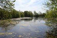
The pit, which is now water filled, is in a field off Brightlingsea Road opposite Broad Lanes.
References
- ↑ "Wivenhoe Gravel Pit citation" (PDF). Sites of Special Scientific Interest. Natural England. Retrieved 8 May 2016.
- ↑ "Map of Wivenhoe Gravel Pit". Sites of Special Scientific Interest. Natural England. Retrieved 8 May 2016.
- ↑ "Wivenhoe Gravel Pit (Quaternary of the Thames)". Joint Nature Conservation Committee. Retrieved 8 May 2016.
- ↑ "Wivenhoe Gravel Pit SSSI, WIVENHOE, Tendring District, TM050235, Site of Special Scientific Interest". The Essex Field Club. Retrieved 8 May 2016.
| Wikimedia Commons has media related to Wivenhoe Gravel Pit. |
Coordinates: 51°52′19″N 0°58′37″E / 51.872°N 0.977°E