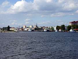
Wolin
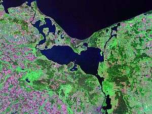
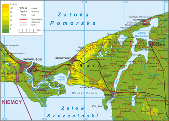
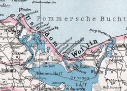
Wolin (German: Wollin, Pomeranian Wòlin) is the name both of a Polish island in the Baltic Sea, just off the Polish coast, and a town on that island. Administratively the island belongs to the West Pomeranian Voivodeship. Wolin is separated from the island of Usedom (Uznam) by the Świna river, and from mainland Pomerania by the Dziwna river. The island has an area of 265 km2 (102 sq mi) and its highest point is Mount Grzywacz at 116 m above sea level
Water from the river Odra (German: Oder) flows into the Szczecin Lagoon and from there through the Peene west of Usedom, Świna and Dziwna into the Bay of Pomerania in the Baltic Sea.
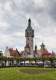
Most of the island consists of forests and postglacial hills. In the middle is the Wolin National Park. The island is a main tourist attraction of northwestern Poland, and it is crossed by several specially marked tourist trails, such as 73-kilometer long trail from Międzyzdroje to Dziwnówek. There is a main, electrified rail line, which connects Szczecin and Świnoujście, plus the international road E65 (national road 3 / S3 expressway) crosses the island.
Etymology
The origins of the name are unknown, although it is likely of Slavic origin. In the old Slavic language the word "wolyn" meant a wetland, and over time, it was Germanised.
History
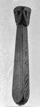
The ford across the river Dzwina on which Wolin is located has been used as far back as the Stone age. Archaeological excavations of soil layers indicate that there was a settlement in the area during the Migration period, at the turn of the 5th and 6th centuries. The place was then abandoned for approximately one hundred years. At the end of the 8th or the beginning of the 9th century the area was leveled and a new settlement constructed. The earliest evidence of fortifications dates to the first half of the 9th century. In the second half of the 9th century there was a central fortified area and two suburbs, to the north and south of the center. These became enclosed and fortified between the end of the 9th and the 10th centuries.[1]
A medieval document from the mid-9th century, called the Bavarian Geographer after its anonymous creator, mentions the Slavic tribe of Wolinians who had 70 strongholds at that time (Uelunzani civitates LXX). The town of Wolin was first mentioned in 965, by Ibrahim ibn Jakub, who referred to the place as Weltaba.[1]
The period of greatest development during the medieval period occurred between the 9th and the 11th centuries. Around 896 AD a new port was constructed and the main part of the town acquired new, stronger fortifications, including a wooden palisade made of halved 50 centimeter wide tree trunks, a rampart and a retaining wall.[1]
Archaeologists believe that in the Early Middle Ages Wolin was a great trade emporium, spreading along the shore for four kilometers and rivaling in importance Birka and Hedeby.
Around 972 the island became controlled by Poland, under prince Mieszko I. However, it has not been established if Wolin became part of Poland, or if it was a fief. Polish influences were not firm and they ended around 1007. In the following years Wolin became famous for its pirates, who would plunder ships cruising the Baltic. As a reprisal, in 1043 it was attacked by the Norwegian king Magnus the Good.[1]
In the early 12th century the island, as part of the Pomeranian duchy, was captured by the Polish king Boleslaw III Wrymouth. Shortly after, the inhabitants of Wolin accepted Christianity, and in 1140 pope Innocent II created a diocese there, with its capital in the town of Wolin. In 1181 the dukes of Pomerania decided to accept the Holy Roman emperor as their liege lord instead of the Polish king.
In 1535 Wolin accepted Protestant Lutheranism. In 1630 the island was captured by Sweden. Later, Pomerania became part of Brandenburg-Prussia (later the Kingdom of Prussia). Wolin followed in 1679. From 1871, the town was part of Germany. After the German-induced Second World War and the Allied agreements that resulted in the transfer of Western Pomerania to Poland in 1945, the (German) population was forcibly expelled to Germany and was replaced with Poles who had been expelled from territories in eastern Poland annexed by the Soviet Union.
Connection with Jomsborg and Vineta
Archaeological finds on the island are not very rich but they dot an area of 20 hectares, making it the second largest Baltic marketplace of the Viking Age after Hedeby. Some scholars have speculated that Wolin may have been the basis for the semi-legendary settlements Jomsborg and Vineta. However, others have rejected the identification, or even the historical existence of Jomsborg and Vineta (for example, Gerard Labuda).[2]
Gwyn Jones notes that the size of the town was exaggerated in contemporary sources, for example by Adam of Bremen who claimed Wolin/Jomsborg was "the largest town in Europe". Archaeological excavations however have found no evidence of a harbor big enough for 360 warships (as claimed by Adam) or of a major citadel. The town was inhabited by both Slavs and Scandinavians.[3]
Viking festival
Annually, the island is home to Europe's biggest Germanic-Slavic Viking festival.[4][5]
See also
Places on Wolin
- Chorzelin
- Dargobądz
- Darzowice
- Domysłów
- Dziwnów
- Jarzębowo
- Kodrąb
- Kołczewo
- Ładzin
- Łunowo
- Łuskowo
- Międzywodzie
- Międzyzdroje
- Mokrzyca Mała
- Mokrzyca Wielka
- Ognica
- Przytór
- Rabiąż
- Świętoujść
- Świnoujście
- Warnowo
- Wapnica
- Wicko
- Wisełka
- Wolin
Distances
- Szczecin-Goleniów "Solidarność" Airport ~ 60 km
- Szczecin ~ 90 km
- Police ~ 110 km
- Berlin ~ 220 km
- Rostock ~ 240 km
- Copenhagen ~ 250 km
- Malmö ~ 250 km
- Warsaw ~ 650 km
References
- 1 2 3 4 Filipowiak, Władysław (2004). "Some aspects of the development of Wolin in the 8th-11th centuries in the light of the results of new research". In Przemysław, Urbanczyk. Polish lands at the turn of the first and the second millennium. Institute of Archeology and Ethnology. Polish Academy of Sciences. pp. 47–74.
- ↑ Koczy, Leon (1960). "Jomsborg". The Polish Review. 5 (3): 38–58. doi:10.2307/25776319.
- ↑ Gwyn Jones. A History of the Vikings. Oxford University Press, 2001. ISBN 0-19-280134-1. Page 127.
- ↑ http://www.jomsborg-vineta.com
- ↑ http://www.wolin.pl
External links
Coordinates: 53°55′N 14°30′E / 53.917°N 14.500°E