Worthington Creek
| Worthington Creek | |
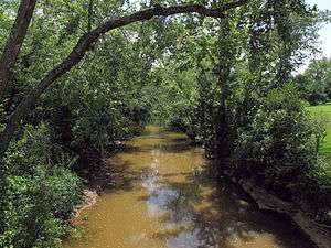 Worthington Creek in Parkersburg in 2010 | |
| Country | United States |
|---|---|
| State | West Virginia |
| County | Wood |
| Source | |
| - location | south of Waverly |
| - elevation | 906 ft (276 m) [1] |
| - coordinates | 39°16′47″N 81°20′48″W / 39.2797976°N 81.3467838°W [2] |
| Mouth | Little Kanawha River |
| - location | Parkersburg |
| - elevation | 587 ft (179 m) [2] |
| - coordinates | 39°15′27″N 81°32′09″W / 39.2575751°N 81.5359569°WCoordinates: 39°15′27″N 81°32′09″W / 39.2575751°N 81.5359569°W [2] |
| Length | 15.4 mi (25 km) |
| Basin | 35 sq mi (91 km2) |
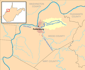 Worthington Creek and its watershed in Wood County, West Virginia | |
Worthington Creek is a tributary of the Little Kanawha River, 15.4 miles (24.8 km) long,[3] in western West Virginia in the United States. Via the Little Kanawha and Ohio rivers, it is part of the watershed of the Mississippi River, draining an area of 35 square miles (91 km2)[4] in the city of Parkersburg and its vicinity.
Worthington Creek flows for its entire length in northern Wood County. It rises approximately 1 mile (1.6 km) south of Waverly and flows generally southwestward to Parkersburg, where it flows into the Little Kanawha River from the north,[5] approximately 1.9 miles (3.1 km) upstream of the Little Kanawha River's mouth.[6]
According to the West Virginia Department of Environmental Protection, approximately 68% of the Worthington Creek watershed is forested, mostly deciduous. Approximately 23% is used for pasture and agriculture, and approximately 9% is developed.[4]
According to the Geographic Names Information System, Worthington Creek has also been known by the name "Worthingtons Creek."[2]
See also
References
- ↑ Google Earth elevation for GNIS source coordinates. Retrieved on 2011-03-07.
- 1 2 3 4 Geographic Names Information System. "Geographic Names Information System entry for Worthington Creek (Feature ID #1553519)". Retrieved 2011-10-13.
- ↑ United States Environmental Protection Agency. "Watershed Assessment, Tracking & Environmental Results: Assessment Summary for Reporting Year 2008, West Virginia, Little Kanawha Watershed". Archived from the original on 2011-10-13. Retrieved 2011-10-13.
- 1 2 West Virginia Department of Environmental Protection. "Little Kanawha River". Watershed Atlas Project. Archived from the original on 2005-04-04. Retrieved 2011-10-13. External link in
|work=(help) - ↑ West Virginia Atlas & Gazetteer. Yarmouth, Me.: DeLorme. 1997. p. 22. ISBN 0-89933-246-3.
- ↑ U.S. Geological Survey. National Hydrography Dataset high-resolution flowline data. The National Map, retrieved 2011-03-12.