Wright Ice Piedmont
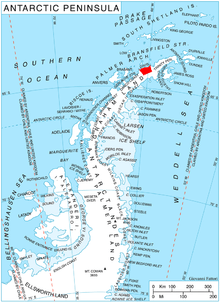
Wright Ice Piedmont (63°58′S 60°20′W / 63.967°S 60.333°WCoordinates: 63°58′S 60°20′W / 63.967°S 60.333°W) is an ice piedmont extending westward from Lanchester Bay along the west coast of Graham Land. Photographed by Hunting Aerosurveys Ltd. in 1955-57 and mapped from these photos by the Falkland Islands Dependencies Survey (FIDS). Named by the United Kingdom Antarctic Place-Names Committee (UK-APC) in 1960 for Wilbur Wright (1867–1912) and his brother Orville Wright (1871–1948), American aeronautical engineers who made the first controlled flights in a powered heavier-than-air machine on December 17, 1903.
![]() This article incorporates public domain material from the United States Geological Survey document "Wright Ice Piedmont" (content from the Geographic Names Information System).
This article incorporates public domain material from the United States Geological Survey document "Wright Ice Piedmont" (content from the Geographic Names Information System).