Wyoming Highway 37
| ||||
|---|---|---|---|---|
| Route information | ||||
| Maintained by WYDOT | ||||
| Length: | 9.00 mi[1] (14.48 km) | |||
| Major junctions | ||||
| South end: |
| |||
| North end: | Bighorn Canyon National Recreation Area | |||
| Location | ||||
| Counties: | Big Horn | |||
| Highway system | ||||
| ||||

Wyoming Highway 37 is a north-south Wyoming state highway located in northern Big Horn County and travels from U.S. Route 14A north into Bighorn Canyon National Recreation Area.
Route description
Wyoming Highway 37 begins at its southern end at U.S. Route 14A, east of Lovell, and travels north into Bighorn Canyon National Recreation Area. State maintenance of WYO 37 ends at 9 miles, but the roadway itself continues north through the National Recreation area, and to Pryor Mountains Wild Horse Range.[2] Into Monatana, the road continues north further into the recreation area and to an area called Barry's Landing.[2]
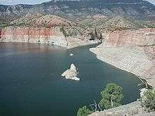
Barry's Landing
Major intersections
The entire route is in Big Horn County.
| Location | mi | km | Destinations | Notes | |
|---|---|---|---|---|---|
| | 0.00 | 0.00 | Southern terminus | ||
| Montana state line | 9.00 | 14.48 | Bighorn Canyon National Recreation Area | Northern terminus | |
| 1.000 mi = 1.609 km; 1.000 km = 0.621 mi | |||||
References
- ↑ Wyoming Routes 000-099
- 1 2 Google (14 August 2016). "Wyoming Highway 37" (Map). Google Maps. Google. Retrieved 14 August 2016.
- Official 2003 State Highway Map of Wyoming
External links
This article is issued from Wikipedia - version of the 8/14/2016. The text is available under the Creative Commons Attribution/Share Alike but additional terms may apply for the media files.