Xagħra
| Xagħra Ix-Xagħra Caccia, Sciara | |||
|---|---|---|---|
| Local council | |||
|
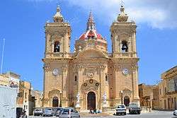
Xagħra parish church | |||
| |||
 | |||
| Coordinates: 36°3′1″N 14°16′3″E / 36.05028°N 14.26750°ECoordinates: 36°3′1″N 14°16′3″E / 36.05028°N 14.26750°E | |||
| Country |
| ||
| Region |
| ||
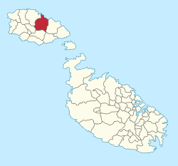
| District | Gozo and Comino District | ||
| Borders | Nadur, Victoria, Xewkija, Żebbuġ | ||
| Government | |||
| • Mayor | Joseph Cordina (PL) | ||
| Area | |||
| • Total | 2.5 km2 (1.0 sq mi) | ||
| Population (March 2014) | |||
| • Total | 4,886 | ||
| • Density | 2,000/km2 (5,100/sq mi) | ||
| Demonym(s) | Xagħri (m), Xagħrija (f), Xagħrin (pl) | ||
| Time zone | CET (UTC+1) | ||
| • Summer (DST) | CEST (UTC+2) | ||
| Postal code | XRA | ||
| Dialing code | 356 | ||
| ISO 3166 code | MT-61 | ||
| Patron saint | Our Lady of Victories | ||
| Day of festa | 8 September | ||
| Website | Official website | ||


Xagħra (Maltese: Ix-Xagħra) is a village on the island of Gozo in Malta. It is possibly the earliest inhabited part of Gozo, being home to the Ġgantija megalithic temples, the Xagħra Stone Circle, as well as natural underground features such as Xerri's Grotto and Ninu's Cave. It is the largest village in Gozo after the capital Victoria, with a population of 4,886 people as of March 2014.[1] During the British period of its history, Xagħra was known as Caccia by foreign residents.[2]
Xagħra Parish
Xagħra Parish is dedicated to Our Lady of Victories, locally known as 'il-Bambina'. The liturgical feast is celebrated on the 8th day of September each year and is a crowd puller as it is the last feast in the summer festa season.
Xagħra Scout Group
Xagħra Scout Group (XSG) has been re-activated and mainly run by youths themselves since 2008. XSG has been open several times notably in 1934, the 1950s and 1970s. During the 1930s period both the Victory Band Club and Xaghra United F.C. emerged from XSG to form their own entities after the war was over. Today the co-ed group boasts around 70 members ranging from the smallest 5 year old beavers to GSL-Emeretius and lifelong member Vincent Vella. The group has recently obtained a lease on a dilapidated property from the Government and is currently restoring it to its former glory to serve as a scouting home for its members. The property is situated at the end of Triq ta' Hamet and is just in front the local playing field and football ground.
Band Clubs
- Victory Band Club (L-Għaqda Mużikali Vittorija)
Xagħra Main Roads
- Triq Jannar (January Street)
- Triq Gajdoru (Gajdoru Road)
- Triq Ġnien Xibla (Xibla Garden Road)
- Triq Għajn Ħosna (Hosna Fountain Road)
- Triq it-Tafla (Clay Street)
- Triq it-Tiġrija (Racecourse street)
- Triq Marsalforn (Marsalforn Road)
- Triq Parisiot (Parisiot Road)
- Triq Ta' Ħamet (Ta' Hamet Road)
- Triq Tal-Masri (Tal-Masri Road)
- Vjal it-8 ta' Settembru (8 September Avenue)
- Triq L-Arcipriet Guzeppi Diacono (Archipriest Joseph Diacono Road)
Other Streets in Xagħra
- Daħla Ċjanti (Cjanti Lane)
- Daħla Egħżien (Eghzien Lane)
- Daħla Għajn Lukin (Ghajn Lukin Road)
- Daħla Ta' Bullara (Bullara Lane)
- Daħla Ta' Sumarat (Sumarat Lane)
- Daħla tal-Ġgantija (Ggantija Lane)
- Daħla tan-Nuffara (Nuffara Lane)
- Pjazza Sant' Anton (St. Anthony Square)
- Pjazza Vittorja (Victory Square)
- Sqaq it-Tiġrija (Tigrija Alley)
- Sqaq ix-Xagħri (Xaghri Alley)
- Sqaq San Marzjan (St. Marzian Alley)
- Trejqa Ġorġ Cini (George Cini Path)
- Trejqa San Ġużepp (St. Joseph Path)
- Triq Dun Vinċenz Cauchi (Fr. Vincent Cauchi Street)
- Triq Franġisk Camilleri (Frances Camilleri Street)
- Triq Ġnien Imrik (Imrik Garden Street)
- Triq Ġużeppi Bajada (Joseph Bajada Street)
- Triq Ġużeppi Grech (Joseph Grech Street)
- Triq Ġużeppi Rapa (Joseph Rapa Street)
- Triq Ġwann M. Camilleri (John M. Camilleri Street)
- Triq George McAdam (George McAdam Street)
- Triq Għajn Lukin (Ghajn Lukin Road)
- Triq Għajn Qamar (Moon Fountain Street)
- Triq Għajn Watar (Ghajn Watar Road)
- Triq Għonqa (Her Neck Street)
- Triq il-Ġnejna (Gnejna Street)
- Triq il-Knisja (Church Street)
- Triq il-Komittiva (Comittivity Street)
- Triq il-Kortoll (Kortoll Street)
- Triq il-Marġa (Marga Street)
- Triq il-Mitħna (Mill Street)
- Triq il-Patrijiet Agostinjani (Agaustinian Brothers Street)
- Triq ir-Rabat (Rabat Road)
- Triq is-Sruġ (Srug Street)
- Triq it-28 ta' April, 1688 (28 April 1688 Street)
- Triq ix-Xagħra (Xaghra Road)
- Triq John Otto Bayer (John Otto Bayer Street)
- Triq Kalipso (Calypso Street)
- Triq l-Arċipriet Ġużepp Diacono (Archpriest Joseph Diacono Street)
- Triq l-Għar Ta' Ninu (Ninu's Cave Street)
- Triq l-Għar Ta' Xerri (Xerri's Grotto Street)
- Triq l-Għejun (Fountains Street)
- Triq l-Ifran (Bakeries Street)
- Triq l-Imqades (Temples Street)
- Triq l-Ispiera (Shaft Street)
- Triq l-Isqof Rużar Farrugia (Bishop Rosario Farrugia Street)
- Triq Laurent Rapa (Laurent Rapa Street)
- Triq Liberat Grech (Liberty Grech Street)
- Triq Mannar (Mannar Street)
- Triq Marija Bambina (Nativity of Our Lady Street)
- Triq Mikelanġ Pace (Michealangelo Pace Street)
- Triq Mikiel Farrugia (Michael Farrugia Street)
- Triq Patri Mattew Sultana (Bro. Matthew Sultana Street)
- Triq Pergla (Pergla Road)
- Triq Qasam ta' Dun Anton (Fr. Anthony Estate Street)
- Triq San Ġużepp (St. Joseph Street)
- Triq San Leonardu (St. Leonard Street)
- Triq Sant' Anton (St. Anthony Street)
- Triq Santa Verna (St. Venera Street)
- Triq Ta' Bertrija (Bertrija Road)
- Triq Ta' Brieret (Brieret Road)
- Triq Ta' Bullara (Bullara Road)
- Triq Ta' Ġorf (Gorf Road)
- Triq Ta' Karkar (Karkar Road)
- Triq Ta' Sansuna (Sansuna Road)
- Triq Ta' Stellini (Stellini Road)
- Triq Tal-Qaċċa (Tal-Qaċċa Street)
- Triq Tas-Sellum (Tas-Sellum Road)
- Triq Vestru (Vestru Street)
See also
References
- ↑ "Estimated Population by Locality 31st March, 2014". Government of Malta. 16 May 2014. Archived from the original on 21 June 2015.
- ↑ Proud, Edward B. (1999). The Postal History of Malta. Heathfield: Proud-Bailey Co. Ltd. p. 256. ISBN 1872465315.
External links
| Wikimedia Commons has media related to Xagħra. |
| Malta Local Councils |
| |
|---|---|---|
| Malta Administrative Committees |
| |
| Gozo Local Councils | ||
| Gozo Administrative Committees | ||