Yachats River
| Yachats River | |
|---|---|
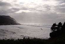 Mouth of the Yachats River | |
| Country | United States |
| Basin | |
| Main source |
Central Oregon Coast Range 1,200 ft (370 m) |
| River mouth |
Pacific Ocean sea level |
| Basin size | 44 sq mi (110 km2)[1] |
| Physical characteristics | |
| Length | 15 mi (24 km) |
| Discharge | |
The Yachats River (/ˈjɑːhɑːts/ YAH-hahts) is a short river on the central Oregon coast, about 60 miles (100 km) west-north-west of Eugene. The name is the native name meaning at the foot of the mountain.[3]
The river begins about 12 miles (19 km) east-south-east of Yachats, Oregon, in steep, thick forest, a half mile north of Klickitat Mountain and flows northward about three miles (5 km), joins Grass Creek then about 0.4 miles (640 m) later joins with School Fork and turns westward. Keller Creek and Stump Creek join after about a mile (1.6 km) of meandering, followed after a half mile (800 m) by Neiglick Creek at river mile 10 (river kilometer 16). The river bed widens significantly and levels out to become very slow moving and turns northward about a half mile, then westward at river mile 8 (river kilometer 13). It meanders westward the rest of the way to the ocean. The sand and stone beach at the river bar is normally very shallow, which allows the tide to change the length of the river as much as a mile.
Named tributaries from source to mouth are Grass Creek, School Fork, then Keller, Stump, and Neiglick creeks followed by the North Fork Yachats River. Below that come Axtell, Helms, Werner, Bend, Clear, Carlson, Dawson, Beamer, South Beamer, Marks, Reedy, and Salmon creeks.[4]
See also
References
- ↑ "Yachats Roadwork Project Environmental Assessment" (PDF). USDA Forest Service. 2006. p. 1. Retrieved 2006-08-20.
- ↑ "NOAA Biological Assessment Invasive Plant EIS" (word document). pp. Figure 11.3. Retrieved 2007-07-31.
- ↑ "Oregon's Covered Bridges—North Fork of the Yachats Bridge". 2004-02-24. Retrieved 2006-08-20.
- ↑ "United States Topographic Map". United States Geological Survey. Retrieved January 16, 2016 – via ACME Mapper. The map includes mile markers along the river as far upstream as Grass Creek.
Coordinates: 44°18′30″N 124°06′28″W / 44.30836°N 124.10772°W