Yokohama Bay Bridge
| Yokohama Bay Bridge | |
|---|---|
 | |
| Coordinates | 35°27′18.36″N 139°40′27.31″E / 35.4551000°N 139.6742528°ECoordinates: 35°27′18.36″N 139°40′27.31″E / 35.4551000°N 139.6742528°E |
| Carries | 3 lanes of Bayshore Route (upper), 1 lane of National Route 357 (lower), pedestrians and bicycles |
| Crosses | Port of Yokohama |
| Locale | between Honmoku and Daikoku Pier, Naka-ku, Yokohama, Kanagawa |
| Characteristics | |
| Design | Cable-stayed |
| Total length | 860 m (2,821.5 ft)[1] |
| Width | 40.2 m (131.9 ft) |
| Height | 172 m (564.3 ft) |
| Longest span | 460 m (1,509.2 ft)[1] |
| Clearance above | Higher truck loads possible |
| Clearance below | 55 m (180.4 ft) |
| History | |
| Opened | September 27, 1989 |
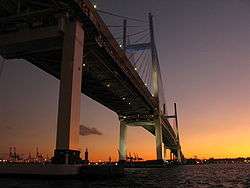
Yokohama Bay Bridge at dawn
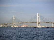
The Yokohama Bay Bridge (横浜ベイブリッジ Yokohama Bei Buridji) is an 860-metre-long cable stayed bridge in Yokohama, Japan. Opened September 27, 1989, it crosses Tokyo Bay with a span of 460 metres (1,510 feet). The toll is ¥600. The bridge is part of the Bayshore Route of the Shuto Expressway.
Notes
- 1 2 "Yokohama Bay Bridge". Ministry of Land, Infrastructure, Transportation and Tourism (MLIT). Retrieved 2010-07-10.
External links
 Media related to Yokohama Bay Bridge at Wikimedia Commons
This article is issued from Wikipedia - version of the 4/16/2016. The text is available under the Creative Commons Attribution/Share Alike but additional terms may apply for the media files.