Youlgreave
| Youlgreave | |
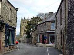 Youlgreave village centre |
|
 Youlgreave |
|
| OS grid reference | SK209642 |
|---|---|
| District | Derbyshire Dales |
| Shire county | Derbyshire |
| Region | East Midlands |
| Country | England |
| Sovereign state | United Kingdom |
| Post town | BAKEWELL |
| Postcode district | DE45 |
| Dialling code | 01629 |
| Police | Derbyshire |
| Fire | Derbyshire |
| Ambulance | East Midlands |
| EU Parliament | East Midlands |
| UK Parliament | West Derbyshire |
|
|
Coordinates: 53°10′30″N 1°41′13″W / 53.175°N 1.687°W
Youlgreave or Youlgrave ![]() listen is a village in the Derbyshire Peak District, lying on the River Bradford, four kilometres south of Bakewell. Both spellings are used on different local signposts and on different maps. The name possibly derives from "yellow grove" (the ore mined locally being yellow in colour),[1][2] though historically the village was called "Giolgrave".[3] The village is locally known as "Pommy".[4]
The population of the parish in 1991 was 1256;[5] it is one of the largest villages wholly within the Peak District National Park.
listen is a village in the Derbyshire Peak District, lying on the River Bradford, four kilometres south of Bakewell. Both spellings are used on different local signposts and on different maps. The name possibly derives from "yellow grove" (the ore mined locally being yellow in colour),[1][2] though historically the village was called "Giolgrave".[3] The village is locally known as "Pommy".[4]
The population of the parish in 1991 was 1256;[5] it is one of the largest villages wholly within the Peak District National Park.
Youlgrave stands on the hillside above the confluence of Lathkill Dale and Bradford Dale.
As well as two public houses (the George Hotel and the Farmyard Inn), the village has a filling station (Youlgreave Garage), a doctors' surgery and two shops (one with a post office annex).
Three long-distance paths, the Alternative Pennine Way, the Limestone Way and the White Peak Way, pass through the village, swelling the numbers of walkers.
History
Youlgreave was mentioned in the Domesday Book as belonging to Henry de Ferrers[6] and being worth sixteen shillings.[7]
All Saints’ Church, Youlgreave has a 12th-century font.
There are also a number of historic buildings in the village, such as Old Hall Farm (1630), Thimble Hall and The Old Hall (c.1650).
Most of the village's households get their water from Youlgreave Water Works Limited, one of very few private water companies in Britain. It came about when Youlgreave Friendly Society for Women helped to set up a fund to pipe water from Mawstone springs into the village. In the 1930s, as new houses were built and older ones were modernised with bathrooms and toilets, water often became short. In 1932 the main underground pipe cracked after an explosion in Mawstone lead mine. Springs at Harthill were connected to the system in 1949 and other major improvements followed. Most homes in the village could be supplied with local water until there were just too many new houses to cope with. Extra supplies are purchased from larger water companies nowadays
In 1932 five of six miners working on a ventilation fan at Mawstone Mine were killed after an explosion filled the gallery with carbon monoxide. The sixth miner was able to reach the surface and raise the alarm. A rescue party of two workers and the mine manager descended into the mine, but were themselves killed by the fumes. Although Mawstone Mine was eventually closed, a water supply for the village is still obtained from this site.[8]
Names
The following is a list of spellings of the name of ‘the most mis-spelt village’ as compiled by local historian and former teacher at Youlgreave school, Mr J W Shimwell:
Giolgrave, Yolgrave, Jalgrave, Hyolgrave, Hyolegrave, Yolgreff, Yoleg, Yolegreve, Yolegrave, Youlgraue, Welegreve, Yoelgreve, Oelgreve, Yelegreve, Yeolegreve, Yolgreave, Yolgreve, Yollegreve, Jol've, Zolgrelf, Yollgreve, Yoligrewe, Yollegrewe, Youlgreve, Zolgreff, Youlgrave, Yolgreyva, Yolgreyve, Yeolgreave, Youlgreave, Yellegrave, Yollogreve, Yollograve, Yeollgreave, Youldgreave, Yograve, Isgrave, Yalgrove, Yolegreue, Jolegreue, lolegrave, Jholegreve, Yelegrave, Yellegrave, Iolgrave, Yholgreve, Yelgreve, Zolgreve,
It is only recently that the Highways Department has used 'Youlgrave', and the Ordnance Survey still use 'Youlgreave', so the argument continues.
Tourism
Because of its scenic location in the Peak District, Youlgreave is a popular destination for hikers.[9] The Limestone Way passes through Bradford Dale, immediately south of the village. Langley Park School for Boys owns a building in the village, which is used for school trips, students taking part in various local sporting activities and a visit to nearby Alton Towers.
A Guinness World Records Certificate names Thimble Hall in Youlgreave as 'the world's smallest detached house' at 11 feet 10 inches (3.61 m) × 10 feet 3 inches (3.12 m) and 12 feet 2 inches (3.71 m) high.[10] The property made national headlines in 1999 when sold at auction for £39,500. Each room is less than 8 feet square and there was a fixed ladder to the bedroom, a stone fireplace, exposed beams and exposed floorboards in the bedroom. It was home to a family of eight around a hundred years ago. It was last occupied as a dwelling in the early 1930s[11] and is currently being converted into a craft gallery.[10] It is a Grade II listed building.[12]
The Youlgreave Festival, founded in 2001, is becoming an increasingly popular event, offering local artists and musicians a chance to showcase their talents.[13]
See also
References
- ↑ Richards, Mark (1985). White Peak Walks: The Northern Dales. Cicerone Press. ISBN 0-902363-53-0.
- ↑ "Youlgrave History". peakdistrictonline.co.uk. Retrieved 21 November 2016.
- ↑ "YOULGREAVE (Ancienty "Giolgrave"), Derbyshire". Genuki. Retrieved 21 November 2016.
- ↑ "Bed & Breakfast In Youlgreave". Peak District online. Retrieved 21 November 2016.
- ↑ "Population and Employment". peakdistrict-education.gov.uk. Archived from the original on 9 March 2010. Retrieved 21 November 2016.
- ↑ Henry was given a large number of manors in Derbyshire including Doveridge, Breaston, Duffield and Cowley.
- ↑ Domesday Book: A Complete Translation. London: Penguin. 2003. p. 748. ISBN 0-14-143994-7.
- ↑ Woolley, Richard (22 May 2007). "Mawstone Mine Disaster – 75 years on". Matlock Mercury.
- ↑ "Middleton–by–Youlgreave". aboutderbyshire.co.uk. Retrieved 21 November 2016.
- 1 2 "Thimble Hall". Retrieved 21 November 2016.
- ↑ "History of Thimble Hall". Thimble Hall. Retrieved 21 November 2016.
- ↑ Historic England. "Thimble Hall (Grade II) (1109818)". National Heritage List for England. Retrieved 21 November 2016.
- ↑ History of Youlgravefest, Official Site, accessed 15 September 2009
External links
| Wikimedia Commons has media related to Youlgreave. |