Yr Aran
| Yr Aran | |
|---|---|
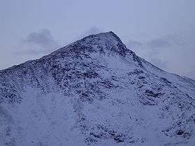 Yr Aran from the Watkin path | |
| Highest point | |
| Elevation | 747 m (2,451 ft) |
| Prominence | 235 m (771 ft) |
| Parent peak | Snowdon |
| Listing | Marilyn, Hewitt, Nuttall |
| Naming | |
| Translation | the peak (Welsh) |
| Pronunciation | Welsh: [əɾ ˈaran] |
| Geography | |
| Location | Gwynedd, Wales |
| Parent range | Snowdonia |
| OS grid | SH604515 |
| Topo map | OS Landranger 115 |
Yr Aran is a mountain peak on a ridge radiating south from Snowdon, Wales' highest mountain, with beautiful views of the summit of Snowdon, Moel Hebog and the Nantlle Ridge.
Although no paths are marked on maps, the ascent is easily made as a detour from the Rhyd Ddu path or the Watkin Path up Snowdon.
External links

Yr Aran summit, seen looking along the east ridge
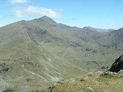
Snowdon's south ridge from the summit of Yr Aran
Coordinates: 53°02′33″N 4°05′01″W / 53.04249°N 4.08372°W
This article is issued from Wikipedia - version of the 1/24/2016. The text is available under the Creative Commons Attribution/Share Alike but additional terms may apply for the media files.