Yunusari
| Agriculture i.e. production of crops like millet, beans, maize, sorghum, ground nut as well as rearing of animals are the main business of people in the Local Government. The main environmental impacts include wind erosion, desertification, deforestation and so on. The local government faces serious effects of climate change. | |
|---|---|
| LGA | |
 Agriculture i.e. production of crops like millet, beans, maize, sorghum, ground nut as well as rearing of animals are the main business of people in the Local Government. The main environmental impacts include wind erosion, desertification, deforestation and so on. The local government faces serious effects of climate change. Location in Nigeria | |
| Coordinates: 13°07′N 11°44′E / 13.117°N 11.733°ECoordinates: 13°07′N 11°44′E / 13.117°N 11.733°E | |
| Country |
|
| State | Yobe State |
| Area | |
| • Total | 3,790 km2 (1,460 sq mi) |
| Population (2006 census) | |
| • Total | 125,821 |
| Time zone | WAT (UTC+1) |
| 3-digit postal code prefix | 632 |
| ISO 3166 code | NG.YO.YN |
Yunusari is a Local Government Area in Yobe State, Nigeria. Its headquarters are in the town of Kanamma (or Kanama) in the north-east of the area on the Burun Gana River at 13°06′15″N 12°04′20″E / 13.10417°N 12.07222°E. It shares a border in the north with The Republic of Niger.
It has an area of 3,790 km² and a population of 125,821 at the 2006 census.
The postal code of the area is 632.[1]
References
- ↑ "Post Offices- with map of LGA". NIPOST. Archived from the original on November 26, 2012. Retrieved 2009-10-20.
State capital: Damaturu | ||
| LGAs | 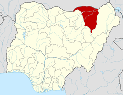 | |
This article is issued from Wikipedia - version of the 9/12/2016. The text is available under the Creative Commons Attribution/Share Alike but additional terms may apply for the media files.