Złotów County
| Złotów County Powiat złotowski | ||
|---|---|---|
| County | ||
| ||
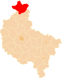 Location within the voivodeship | ||
| Coordinates (Złotów): 53°21′37″N 17°2′27″E / 53.36028°N 17.04083°ECoordinates: 53°21′37″N 17°2′27″E / 53.36028°N 17.04083°E | ||
| Country |
| |
| Voivodeship | Greater Poland | |
| Seat | Złotów | |
| Gminas | ||
| Area | ||
| • Total | 1,660 km2 (640 sq mi) | |
| Population (2011) | ||
| • Total | 68,791 | |
| • Density | 41/km2 (110/sq mi) | |
| • Urban | 34,302 | |
| • Rural | 34,489 | |
| Car plates | PZL | |
| Website | http://www.zlotow-powiat.pl | |
Złotów County (Polish: powiat złotowski) is a unit of territorial administration and local government (powiat) in Greater Poland Voivodeship, west-central Poland. Its administrative seat and largest town is Złotów, which lies 107 kilometres (66 mi) north of the regional capital Poznań. The county contains three other towns: Jastrowie, 17 km (11 mi) northwest of Złotów, Okonek, 23 km (14 mi) northwest of Złotów, and Krajenka, 7 km (4 mi) southwest of Złotów.
The county covers an area of 1,661 square kilometres (641.3 sq mi). As of 2011, its total population is 68,791, out of which the population of Złotów is 18,303, that of Jastrowie is 8,485, that of Okonek is 3,855, that of Krajenka is 3,659, and the rural population is 34,489.
History
Before 1772, the area was part of the Kingdom of Poland. From 1772 to 1945, it was part of Prussia and Germany, contained mainly in the district called Kreis Flatow (Złotów), although parts were in Kreis Deutsch Krone (Jastrowie). For more information, see Territorial changes of Poland after World War II.
In post-war Poland, Złotów County was in Szczecin Voivodeship from 1946 to 1950, and then in Koszalin Voivodeship until 1975, when the powiats were abolished. From 1975 until 1998, the area was part of Piła Voivodeship. The county was recreated on January 1, 1999, as a result of the Polish local government reforms passed in 1998, which reintroduced the powiats and created sixteen larger voivodeships.
Neighbouring counties
Złotów County is bordered by Szczecinek County to the northwest, Człuchów County to the northeast, Sępólno County to the east, Piła County to the south, and Wałcz County and Drawsko County to the west.
Administrative division
The county is subdivided into eight gminas (one urban, three urban-rural and four rural). These are listed in the following table, in descending order of population.
| Gmina | Type | Area (km²) |
Population (2011) |
Seat |
| Złotów | urban | 11.6 | 18,303 | |
| Gmina Jastrowie | urban-rural | 353.4 | 11,549 | Jastrowie |
| Gmina Złotów | rural | 292.5 | 9,307 | Złotów * |
| Gmina Okonek | urban-rural | 325.9 | 8,809 | Okonek |
| Gmina Krajenka | urban-rural | 191.8 | 7,301 | Krajenka |
| Gmina Lipka | rural | 191.0 | 5,557 | Lipka |
| Gmina Zakrzewo | rural | 162.5 | 4,847 | Zakrzewo |
| Gmina Tarnówka | rural | 132.2 | 3,118 | Tarnówka |
| * seat not part of the gmina | ||||
External links
References
| Seat |
|  |
|---|---|---|
| Urban-rural gminas | ||
| Rural gminas | ||
| City counties |  | |
|---|---|---|
| Land counties | ||