Zacatal Bridge
| Zacatal Bridge Puente El Zacatal | |
|---|---|
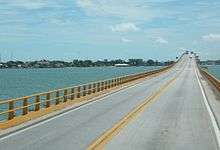 Zacatal Bridge on 23 June 2006 | |
| Coordinates | 18°37′16″N 91°50′28″W / 18.621°N 91.841°WCoordinates: 18°37′16″N 91°50′28″W / 18.621°N 91.841°W |
| Carries | Mexican Federal Highway 180 |
| Crosses | Laguna de Términos |
| Locale | Ciudad del Carmen, Campeche, Mexico |
| Characteristics | |
| Design | beam bridge |
| Material | concrete |
| Total length | 3,861 metres (12,667 ft) |
| Width | 9 metres (30 ft) (2 lanes) |
| History | |
| Construction end | October 1994 |
The Zacatal Bridge (Spanish: Puente El Zacatal) is located southwest of Ciudad del Carmen, in the state of Campeche in Mexico. It connects the Atasta peninsula and the Isla del Carmen.
This is the longest bridge in the state and at the time of opening the longest in Mexico with a length of 3,861 m and a width of 9.00 m. It is a two-lane road bridge for the Federal Highway 180. It is one of the busiest in the country since it is the gateway to the Yucatán Peninsula.
The superstructure is composed entirely of prefabricated elements to base being: 121 heads of precast concrete, 496 Type IV girders Aastha amended and 8 box girders well as 124 post-tensioned concrete slabs. It was completed in October 1994.

Sunset from Ciudad del Carmen, 27 December 2006
External links
| Wikimedia Commons has media related to Puente El Zacatal. |
This article is issued from Wikipedia - version of the 8/19/2013. The text is available under the Creative Commons Attribution/Share Alike but additional terms may apply for the media files.