Zaria
| Zaria | ||
|---|---|---|
| LGA and city | ||
|
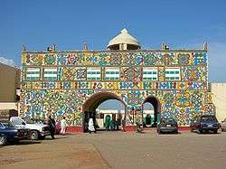
Gate to the palace of the emir of Zazzau | ||
| ||
 Zaria | ||
| Coordinates: 11°04′N 7°42′E / 11.067°N 7.700°E | ||
| Country |
| |
| State | Kaduna State | |
| Area | ||
| • Total | 563 km2 (217 sq mi) | |
| Population (2006 Census) | ||
| • Total | 695,089 | |
| • Density | 1,200/km2 (3,200/sq mi) | |
| Time zone | WAT (UTC+01:00) | |
| Climate | Aw | |

Zaria is a major city in Kaduna State in northern Nigeria, as well as being a Local Government Area. Formerly known as Zazzau, it was one of the original seven Hausa city-states. Today it is known for housing Nigeria's largest university, Ahmadu Bello University, as well as being home to a number of prominent Nigerians.
The 2006 Census population was estimated as 406,990. It is home to the Zazzau Emirate.
History
Zaria, initially known as Zazzau, was the capital of the Hausa kingdom of Zazzau.[1] Zazzau is thought to have been founded in 1536 and later was renamed after Queen Zaria.[2] Human settlement predates the rise of Zazzau, as the region, like some of its neighbors, had a history of sedentary Hausa settlement, with institutional, pre-capitalist market exchange and farming.
Zaria was the most southern of the Hausa city-states. It was a trading destination for Saharan caravans as well as a prominent city in the Hausa slave trade. In the late 1450s, Islam arrived in Zaria by the way of its sister Habe cities, Kano and Katsina. Along with Islam, trade flourished between the cities as traders brought camel caravans filled with salt in exchange for slaves and grain.The city-state's power peaked under Queen Amina whose military campaigns established a tributary region including the kingdoms of Kano and Katsina. At the end of the 16th century, after Queen Amina's death, Zaria fell under the influence of the Jukun Kingdom and eventually became a tributary state itself.[1] Between the fifteenth and sixteenth century the kingdom became a tributary state of the Songhai Empire. In 1805 it was captured by the Fulani during the Fulani Jihad. British forces led by Frederick Lugard took the city in 1901.
A French hostage of the Islamist group Ansaru, held captive at Zaria,[3] escaped in 2013 and reached a police station in the city.
In December 2015, Nigeria's military was reported to have killed 300 Shia Muslims and buried their bodies in a mass grave. Although the government denies the event, it has been described as a Massacre.[4]
Cityscape
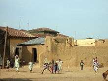
The old part of the city, known as Birnin Zazzau[5] or Zaria-City, was originally surrounded by walls and fortress, which have been mostly removed.[6] The Emir's palace is in the old city. In the old city and the adjacent Tudun Wada neighbourhood people typically reside in traditional adobe compounds. These two neighborhoods are predominantly occupied by the indigenous Hausa.[5]
The neighborhoods of Samaru and Sabon Gari are predominantly occupied by Nigerians of southern origin, such as the Igbo.[5] These neighborhoods were formed during the colonial period.[2] The largest marketplace is in Sabon Gari.[7] Other more recent neighborhoods include Danmagaji/Wusasa, PZ, Kongo, GRA-Zaria, Hanwa, Bassawa, Lowcost Kofan-Gayan and Shikka.[6]
There is great variety in the architecture of Zaria, with buildings made of clay in the Hausa style juxtaposed with modern, multi-storied university and government buildings.[8]
Transport and economy
Zaria's economy is primarily based on agriculture. Staples are guinea corn and millet. Cash crops include cotton, groundnuts and tobacco.[1] The city is considered by some to be a main center of Hausa agriculture. Not only is Zaria a market town for the surrounding area, it is the home of artisans, from traditional crafts like leather work, dyeing and cap making, to tinkers, printshops and furniture makers.[5] Zaria is also the center of a textile industry that for over 200 years has made elaborately hand-embroidered robes that are worn by men throughout Nigeria and West Africa.[9]
Because Zaria is north of the rail junction at Kaduna, it has equal rail access to the seaports at Lagos and Port Harcourt. However, only the railway between Lagos and Kano is functional, as the eastern line of Nigeria's rail network is not operational. This means that Zaria currently has rail access to Lagos and Kano to the north but not Port Harcourt.[10][11]
From 1914 to 1927, Zaria was the break-of-gauge junction station for the Bauchi Light Railway to the tin mines at Jos.
Education

Zaria is home to Ahmadu Bello University, the largest university in Nigeria and the second largest on the African continent. The institution is very prominent in the fields of Agriculture, Science, Finance, Medicine and Law.
Zaria is also the base for the Nigerian College of Aviation Technology,[12] National Research Institute for Chemical Technology,[13] and Barewa College. The school is known for the large number of elites from the region that passed through its academic buildings and counts among its alumni five who were Nigerian heads of state, including the late president Umaru Musa Yar'Adua. (There are two other famous schools in Wusasa, where the former head of state Yakubu Gowon reside: St. Bartholomew's School and Science School Kufena formerly known as St. Paul's College.)
Climate
Zaria has a tropical wet and dry climate with warm weather year round, a wet season lasting from March to September, and a drier season from October to February.[14]
| Climate data for Zaria | |||||||||||||
|---|---|---|---|---|---|---|---|---|---|---|---|---|---|
| Month | Jan | Feb | Mar | Apr | May | Jun | Jul | Aug | Sep | Oct | Nov | Dec | Year |
| Daily mean °C (°F) | 22.7 (72.9) |
24.7 (76.5) |
28.3 (82.9) |
29.8 (85.6) |
28.2 (82.8) |
26.3 (79.3) |
24.7 (76.5) |
24.5 (76.1) |
24.8 (76.6) |
26.0 (78.8) |
24.3 (75.7) |
23.1 (73.6) |
25.6 (78.1) |
| Average precipitation mm (inches) | 0.0 (0) |
2.5 (0.098) |
5.1 (0.201) |
44.4 (1.748) |
119.4 (4.701) |
154.9 (6.098) |
221.0 (8.701) |
310.0 (12.205) |
222.3 (8.752) |
35.6 (1.402) |
2.5 (0.098) |
0.0 (0) |
1,117.6 (44) |
| Average relative humidity (%) (at 07:00 LST) | 36 | 34 | 38 | 60 | 84 | 87 | 91 | 94 | 93 | 86 | 54 | 43 | 69 |
| Source: Deutscher Wetterdienst[15] | |||||||||||||
Notable births and residents
Notable births and current and former residents of Zaria include:
- Ibrahim Zakzaky, Islamic cleric, leader of the Shia Islamic Movement (Nigeria)
- Shola Ameobi, football player
- D'banj, music artist
- Edoheart, musician, poet, dancer
- Bola Ige, lawyer and politician
- Rilwanu Lukman, engineer and former Secretary General of OPEC
- Rumun Ndur, professional ice hockey player
- Josephine Obiajulu Odumakin, women's rights activist
- Adewale Olukoju, athlete
- Isaac Promise, football player
- Namadi Sambo, former Vice President of Nigeria
- Masai Ujiri, general manager of the Toronto Raptors of the NBA and first international winner of the NBA Executive of the Year award
- Adebusola Onayemi, medical doctor, author and reverend
- Mukhtar Ramalan Yero, former Governor of Kaduna State
- Nasir Ahmed El-Rufa'i, former FCT minister and present governor of Kaduna State
- Bashir Sambo, former Grand Kadi of the FCT and former chairman of the Code of Conduct Tribunal
- Mohammed Lawal Uwais, former Chief Justice of Nigeria
- Gidado Idris, late Secretary to the Government of the Federation of Nigeria
- Olusegun Obasanjo, former President of Nigeria
- Alkali Gambo, Alkalin Garkan Zazzau (Chief Judge of Zazzau) and the Patriarch of the Alkalawa clan of Anguwar Alkali Zaria City
- Colonel Chukwuemeka Odumegwu Ojukwu, Nigerian secessionist and proclaimed ruler of Biafra
- Yakubu Gowon, former military Head of State of Nigeria
- Umaru Dikko, minister in the second republic
- Abubakar Imam, author and novelist
- Sheikh Muhammad Awwal Albani Zaria, Islamic Scholar Salafi Movement
See also
Bibliography
- Smith, Michael G. (1960) Government in [Zazzau 1800–1950 International African Institute by the Oxford University Press, London, OCLC 293592; reprinted in 1964 and 1970.
- Dan Isaacs (September 28, 2010). "Nigeria's emirs: Power behind the throne". BBC News. Retrieved September 29, 2010.
References
- 1 2 3 "The Britannica Encyclopedia". Retrieved 2007-02-04.
- 1 2 "Zaria | Nigeria". Encyclopedia Britannica. Retrieved 2016-11-05.
- ↑ Le Monde, 13th March 2015
- ↑ "Mass graves for '300 Shia Nigerians' in Zaria". BBC News. 2015-12-23. Retrieved 2016-11-05.
- 1 2 3 4 Gihring, Thomas (1984) "Intraurban Activity Patterns among Entrepreneurs in a West African Setting" Human Geography (Geografiska Annaler Series B) 66(1): pp. 17–27, page 19
- 1 2 "Welcome to Zaria" Archived October 27, 2009, at the Wayback Machine. Biotechnology Society of Nigeria (BSN) at Ahmadu Bello University
- ↑ Gihring, Thomas (1984) "Intraurban Activity Patterns among Entrepreneurs in a West African Setting" Human Geography (Geografiska Annaler Series B) 66(1): pp. 17–27, page 20
- ↑ "Zaria". Encyclopedia Britannica. Retrieved 2016-11-05.
- ↑ Maiwada, Salihu and Renne, Elisha P. (2007) "New Technologies of Embroidered Robe Production and Changing Gender Roles in Zaria, Nigeria, 1950–2005" Textile History 38(1): pp. 25-58, page 25
- ↑ "Can Nigeria's renovated railway unite north and south?". BBC News. February 13, 2013. Retrieved December 11, 2013.
- ↑ "Trains in Nigeria: A slow but steady new chug". The Economist. February 9, 2013. Retrieved March 4, 2014.
- ↑ "About Us". Nigerian College of Aviation Technology. Retrieved March 27, 2010.
- ↑ "National Research Institute for Chemical Technology (NARICT, Nigerian Institute of Transport Technology (NITT), National Research Institute for Chemical Technology): About Us". Archived from the original on July 24, 2011. Retrieved June 27, 2010.
- ↑ Hotels.ng. "Ahmadu Bello University | Hotels.ng". Hotels.ng. Retrieved 2016-11-05.
- ↑ "Klimatafel von Zaria / Nigeria" (PDF). Baseline climate means (1961-1990) from stations all over the world (in German). Deutscher Wetterdienst. Retrieved 10 August 2016.
External links
![]() Media related to Zaria at Wikimedia Commons
Media related to Zaria at Wikimedia Commons
Coordinates: 11°04′00″N 07°42′00″E / 11.06667°N 7.70000°E
State capital: Kaduna | ||
| LGAs | 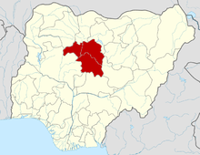 | |