Zumbro River
The Zumbro River is a tributary of the Mississippi River in the Driftless Area of southeastern Minnesota in the United States. It is 64.6 miles (104.0 km) long[1] from the confluence of its principal tributaries and drains a watershed of 1,428 square miles (3,700 km2). The river's name in English is a change from its French name Rivière des Embarras (Embarrass River/Obstruction River) due to its mouth located near Pine Island in the Mississippi River; the Dakota name for this river is Wapka Wazi Oju (Pines Planted River), having reference to the grove of great white pines at Pine Island.[2]
Course
The Zumbro rises as three forks:
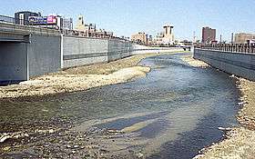
The South Fork Zumbro River, 57.6 miles (92.7 km) long,[1] rises about 2 miles (3 km) east of Hayfield in southern Dodge County and flows generally eastwardly into Olmsted County, where it turns northward at Rochester and flows into southwestern Wabasha County. The South Fork's course through Rochester has been channelized as part of a flood control project. It is dammed in Wabasha County, by the Lake Zumbro Hydroelectric Generating Plant to form Lake Zumbro.
The Middle Fork Zumbro River, 52.9 miles (85.1 km) long,[1] rises in northeastern Steele County, about 8 miles (13 km) west of West Concord and flows generally eastwardly through northern Dodge, southwestern Goodhue and northeastern Olmsted counties, past Pine Island and Oronoco. At Pine Island it collects the North Branch Middle Fork Zumbro River, which rises in southwestern Goodhue County and flows eastwardly through southern Goodhue and northern Dodge counties. At Oronoco it collects the South Branch Middle Fork Zumbro River, which rises in eastern Steele County and flows eastwardly into Dodge County, past Mantorville. The Middle Fork meets the South Fork in north-central Olmsted County as part of Zumbro Lake.
The North Fork Zumbro River, 57.5 miles (92.5 km) long,[1] rises 7.5 miles (12.1 km) southeast of Faribault in southeastern Rice County and flows eastwardly through southern Goodhue and southwestern Wabasha counties, past Kenyon, Wanamingo, Zumbrota and Mazeppa.
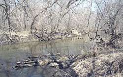
The North and South forks join about 4 miles (6 km) east of Mazeppa in southwestern Wabasha County, and the Zumbro River flows eastwardly through Wabasha County, through the Richard J. Dorer Memorial Hardwood State Forest and past Zumbro Falls, Hammond, Millville and Kellogg. It flows into the Mississippi River about 4 miles (6 km) east of Kellogg.
Fish species near Rochester
Some species of fish that can be found in the Zumbro River near Rochester include Green Sunfish, Rock Bass, Smallmouth Bass, Largemouth Bass, Common Carp and Creek Chub, Channel Catfish, Blue Catfish, Northern Pike.
See also
Sources
- Columbia Gazetteer of North America entry
- DeLorme (1994). Minnesota Atlas & Gazetteer. Yarmouth, Maine: DeLorme. ISBN 0-89933-222-6.
- U.S. Geological Survey Geographic Names Information System: Zumbro River
- Waters, Thomas F. (1977). The Streams and Rivers of Minnesota. Minneapolis: University of Minnesota Press. ISBN 0-8166-0960-8.
- 1 2 3 4 U.S. Geological Survey. National Hydrography Dataset high-resolution flowline data. The National Map Archived 2012-04-05 at WebCite, accessed October 4, 2012
- ↑ Upham, Warren (1920). Minnesota Geographic Names: Their Origin and Historic Significance. Minnesota Historical Society. p. 559.
Coordinates: 44°17′30″N 91°55′41″W / 44.29163°N 91.92794°W