Caeté
| Caeté | |||
|---|---|---|---|
| City | |||
|
Partial view of Caeté | |||
| |||
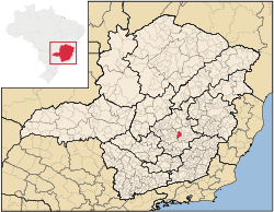 | |||
 Caeté Location in Brazil | |||
| Coordinates: 19°52′48″S 43°40′12″W / 19.88000°S 43.67000°WCoordinates: 19°52′48″S 43°40′12″W / 19.88000°S 43.67000°W | |||
| Country |
| ||
| Region | Southeast | ||
| State | Minas Gerais | ||
| Mesoregion | Metropolitan of Belo Horizonte | ||
| Microregion | Belo Horizonte | ||
| Settled | 17th century | ||
| Incorporated | February 12th, 1714 | ||
| Government | |||
| • Mayor | Joao Antonio da Trindade | ||
| Area[1] | |||
| • Total | 208,918 sq mi (541,094 km2) | ||
| Elevation | 3,100 ft (945 m) | ||
| Population (2013)[2] | |||
| • Total | 43,036 | ||
| Time zone | BRT (UTC-3) | ||
| • Summer (DST) | BRST (UTC-2) | ||
| CEP | 34800-000 | ||
| Area code(s) | 31 | ||
| HDI (2010) [3] | 0.728 | ||
| Website | Official Website | ||


Caeté is a Brazilian municipality located in the state of Minas Gerais. The city belongs to the mesoregion Metropolitana de Belo Horizonte and to the microregion of Belo Horizonte.
The name Caeté is derived from the local term for some Marantaceae, in particular Stromanthe and Thalia.
The municipality contains a small part of the 31,270 hectares (77,300 acres) Serra do Gandarela National Park, created in 2014.[4]
References
- ↑ "Área territorial oficial" [Official Territorial Area] (in Portuguese). Brazilian Institute of Geography and Statistics (IBGE). 2002-10-10. Retrieved 2010-12-05.
- ↑ "Estimativa População 2013" [Population estimation - 2013] (PDF) (in Portuguese). Brazilian Institute of Geography and Statistics (IBGE). 2013-08-29. Retrieved 2013-08-29.
- ↑ "Ranking decrescente do IDH-M dos municípios do Brasil" [Ranking of HDI-M of Brazilian Municipalities] (PDF) (in Portuguese). United Nations Development Programme (UNDP). 2010. Retrieved 2013-08-03.
- ↑ PARNA de Serra do Gandarela (in Portuguese), ISA: Instituto Socioambiental, retrieved 2016-06-12
See also
This article is issued from Wikipedia - version of the 10/16/2016. The text is available under the Creative Commons Attribution/Share Alike but additional terms may apply for the media files.