Èvre
| Èvre | |
|---|---|
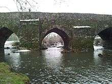 The Èvre in Montrevault | |
| Native name | L'Èvre (f) |
| Country | France |
| Basin | |
| Main source |
Vezins 161 m (528 ft) 47°07′50″N 00°41′39″W / 47.13056°N 0.69417°W |
| River mouth |
Loire 10 m (33 ft) 47°21′49″N 1°02′00″W / 47.36361°N 1.03333°WCoordinates: 47°21′49″N 1°02′00″W / 47.36361°N 1.03333°W |
| Progression | Loire→ Atlantic Ocean |
| Basin size | 573 km2 (221 sq mi) |
| Physical characteristics | |
| Length | 92 km (57 mi) |
| Discharge |
|
The Èvre is a 92 km (57 mi) long river in western France, left tributary of the Loire. Its source is at Vezins, 1.5 km (0.93 mi) northeast of the village. It flows into the Loire at Le Marillais, 3 km (1.9 mi) east of the village.
The Èvre flows through the following communes in the Maine-et-Loire département, ordered from source to mouth: Vezins, La Tourlandry, Trémentines, Le May-sur-Èvre, La Jubaudière, Jallais, La Poitevinière, Beaupréau, La Chapelle-du-Genêt, Le Fief-Sauvin, Montrevault, Saint-Pierre-Montlimart, Saint-Rémy-en-Mauges, La Boissière-sur-Èvre, La Chapelle-Saint-Florent, Botz-en-Mauges, Saint-Florent-le-Vieil, Le Marillais
Notes
- This article is based on the equivalent article from the French Wikipedia, consulted on January 23rd 2009.
References
| Wikimedia Commons has media related to Èvre. |
This article is issued from Wikipedia - version of the 6/19/2016. The text is available under the Creative Commons Attribution/Share Alike but additional terms may apply for the media files.