Định Hóa District
| Định Hóa District Huyện Định Hóa | |
|---|---|
| Rural district | |
 Định Hóa District | |
| Coordinates: VN 21°53′50″N 105°38′01″E / 21.89722°N 105.63361°E | |
| Country |
|
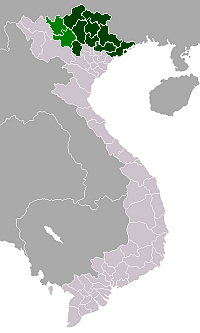
| Region | Northeast |
| Province | Thái Nguyên |
| Capital | Chợ Chu |
| Area | |
| • Total | 201 sq mi (521 km2) |
| Population (2003) | |
| • Total | 90,086 |
| Time zone | UTC + 7 (UTC+7) |
Định Hóa is a rural district of Thái Nguyên Province in the Northeast region of Vietnam. As of 2003 the district had a population of 90,086.[1] The district covers an area of 521 km². The district capital lies at Chợ Chu.[1]
Administrative divisions
Chợ Chu, Bảo Cường, Bảo Linh, Bình Thành, Bình Yên, Bộc Nhiêu, Điềm Mặc, Định Biên, Đồng Thịnh, Kim Phượng, Kim Sơn, Lam Vỹ, Linh Thông, Phú Đình, Phú Tiến, Phúc Chu, Phượng Tiến, Quy Kỳ, Sơn Phú, Tân Dương, Tân Thịnh, Thanh Định, Trung Hội, Trung Lương.
References
- 1 2 "Districts of Vietnam". Statoids. Retrieved March 23, 2009.
This article is issued from Wikipedia - version of the 10/29/2013. The text is available under the Creative Commons Attribution/Share Alike but additional terms may apply for the media files.